Kesovogorsky District
| Kesovogorsky District Кесовогорский район (Russian) | |
|---|---|
 Location of Kesovogorsky District in Tver Oblast | |
| Coordinates: 57°35′N 37°17′E / 57.583°N 37.283°ECoordinates: 57°35′N 37°17′E / 57.583°N 37.283°E | |
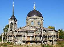
 Central part of the urban-type settlement of Kesova Gora, the administrative center of Kesovogorsky District | |
.png) |
.png) |
|
| |
| Location | |
| Country | Russia |
| Federal subject | Tver Oblast[1] |
| Administrative structure (as of 2012) | |
| Administrative center | urban-type settlement of Kesova Gora[1] |
| Administrative divisions: | |
| Urban settlements | 1 |
| Rural settlements | 6 |
| Inhabited localities: | |
| Urban-type settlements[2] | 1 |
| Rural localities | 174 |
| Municipal structure (as of April 2009) | |
| Municipally incorporated as | Kesovogorsky Municipal District[3] |
| Municipal divisions:[4] | |
| Urban settlements | 1 |
| Rural settlements | 6 |
| Statistics | |
| Area | 962 km2 (371 sq mi)[5] |
| Population (2010 Census) | 8,199 inhabitants[6] |
| • Urban | 47.3% |
| • Rural | 52.7% |
| Density | 8.52/km2 (22.1/sq mi)[7] |
| Time zone | MSK (UTC+03:00)[8] |
| Official website | |
| Kesovogorsky District on WikiCommons | |
Kesovogorsky District (Russian: Кесового́рский райо́н) is an administrative[1] and municipal[3] district (raion), one of the thirty-six in Tver Oblast, Russia. It is located in the east of the oblast and borders with Sonkovsky District in the north, Myshkinsky District of Yaroslavl Oblast in the east, Uglichsky District, also of Yaroslavl Oblast, in the southeast, Kashinsky District in the south, and with Bezhetsky District in the west. The area of the district is 962 square kilometers (371 sq mi).[5] Its administrative center is the urban locality (an urban-type settlement) of Kesova Gora.[1] Population: 8,199 (2010 Census);[6] 9,289 (2002 Census);[9] 10,235 (1989 Census).[10] The population of Kesova Gora accounts for 47.3% of the district's total population.[6]
Geography
The whole area of the district belongs to the drainage basin of the Volga. The areas in the north and the east of the district belong to the drainage basin of the Korozhechna River. The source of the Korozhechna lies in the northwestern part of the district. The rivers in the center and the west of the district drain into the Kashinka River. The Kashinka crosses the district from the west to the east, and, in particular, Kesova Gora is located on its banks. Finally, minor areas in the south of the district belong to the basin of the Medveditsa River. The Korozhechna, the Kashinka, and the Medveditsa are left tributaries of the Volga.
History
In the course of the administrative reform carried out in 1708 by Peter the Great, the area was included into Ingermanland Governorate (known since 1710 as Saint Petersburg Governorate), but in 1727 it was transferred to Moscow Governorate. In 1775, Tver Viceroyalty was formed from the lands which previously belonged to Moscow and Novgorod Governorates. The western part of the current area of the district, including Kesova Gora, was split between Bezhetsky and Kashinsky Uyezds of Tver Viceroyalty. In 1796, Tver Viceroyalty was transformed into Tver Governorate. On October 3, 1927 Kashinsky Uyezd was abolished and split between Bezhetsky and Kimrsky Uyezds; the area of the district which previously belonged to Kashinsky Uyezd, was transferred to Bezhetsky Uyezd.[11] The eastern part of the current area of the district was in 1777 transferred to newly established Yaroslavl Viceroyalty, since 1796 Yaroslavl Governorate. It belonged to Myshkinsky Uyezd.
On July 12, 1929 the governorates and uyezds were abolished. Kesovsky District, with the administrative center in the selo of Kesova Gora, was established within Bezhetsk Okrug of Moscow Oblast. Shortly afterwards, the district was renamed Kesovogorsky. On July 23, 1930, the okrugs were abolished, and the districts were directly subordinated to the oblast. On January 29, 1935 Kalinin Oblast was established, and Kesovogorsky District was transferred to Kalinin Oblast. On February 13, 1963, during the abortive Khrushchyov administrative reform, Kesovogorsky District was merged into Kashinsky District, but on November 3, 1965 it was re-established.[11] In 1975, Kesova Gora was granted urban-type settlement status.[12] In 1990, Kalinin Oblast was renamed Tver Oblast.
Economy
Industry
The industry in the district is based on timber production.[5]
Agriculture
Agriculture is the basis of the economy of the district. The main agricultural specializations in the district are cattle breeding with meat and milk production, as well as crops and vegetables growing. The agriculture is in deep crisis, and the farms get reorganized. As of 2011, there were seventeen large- and mid-scale farms in the district.[13]
Transportation

A railway connecting Moscow with Mga via Sonkovo crosses the district from south to north. Kesova Gora is the main railway station within the district. There is infrequent passenger traffic.
Kesova Gora is connected by paved roads with Bezhetsk and Kashin. There are also local roads.
Culture and recreation
The district contains two cultural heritage monuments of federal significance and additionally eighteen objects classified as cultural and historical heritage of local significance. The federal monuments are the Saint Nicholas Church (1770s) in Kesova Gora and the Church of the Deposition of the Robe from the 18th century in the selo of Vasilkovo.[14]
There is a local museum in Kesova Gora.[12]
References
Notes
- 1 2 3 4 Государственный комитет Российской Федерации по статистике. Комитет Российской Федерации по стандартизации, метрологии и сертификации. №ОК 019-95 1 января 1997 г. «Общероссийский классификатор объектов административно-территориального деления. Код 28 226», в ред. изменения №259/2014 от 12 декабря 2014 г.. (State Statistics Committee of the Russian Federation. Committee of the Russian Federation on Standardization, Metrology, and Certification. #OK 019-95 January 1, 1997 Russian Classification of Objects of Administrative Division . Code 28 226, as amended by the Amendment #259/2014 of December 12, 2014. ).
- ↑ The count of urban-type settlements may include the work settlements, the resort settlements, the suburban (dacha) settlements, as well as urban-type settlements proper.
- 1 2 Law #4-ZO
- ↑ Law #29-ZO
- 1 2 3 Кесовогорский район (in Russian). Законодательное Собрание Тверской области. Retrieved 20 August 2013.
- 1 2 3 Russian Federal State Statistics Service (2011). "Всероссийская перепись населения 2010 года. Том 1" [2010 All-Russian Population Census, vol. 1]. Всероссийская перепись населения 2010 года (2010 All-Russia Population Census) (in Russian). Federal State Statistics Service. Retrieved June 29, 2012.
- ↑ The value of density was calculated automatically by dividing the 2010 Census population by the area specified in the infobox. Please note that this value is only approximate as the area specified in the infobox does not necessarily correspond to the area of the entity proper or is reported for the same year as the population.
- ↑ Правительство Российской Федерации. Федеральный закон №107-ФЗ от 3 июня 2011 г. «Об исчислении времени», в ред. Федерального закона №271-ФЗ от 03 июля 2016 г. «О внесении изменений в Федеральный закон "Об исчислении времени"». Вступил в силу по истечении шестидесяти дней после дня официального опубликования (6 августа 2011 г.). Опубликован: "Российская газета", №120, 6 июня 2011 г. (Government of the Russian Federation. Federal Law #107-FZ of June 31, 2011 On Calculating Time, as amended by the Federal Law #271-FZ of July 03, 2016 On Amending Federal Law "On Calculating Time". Effective as of after sixty days following the day of the official publication.).
- ↑ Russian Federal State Statistics Service (May 21, 2004). "Численность населения России, субъектов Российской Федерации в составе федеральных округов, районов, городских поселений, сельских населённых пунктов – районных центров и сельских населённых пунктов с населением 3 тысячи и более человек" [Population of Russia, Its Federal Districts, Federal Subjects, Districts, Urban Localities, Rural Localities—Administrative Centers, and Rural Localities with Population of Over 3,000] (XLS). Всероссийская перепись населения 2002 года [All-Russia Population Census of 2002] (in Russian). Retrieved August 9, 2014.
- ↑ Demoscope Weekly (1989). "Всесоюзная перепись населения 1989 г. Численность наличного населения союзных и автономных республик, автономных областей и округов, краёв, областей, районов, городских поселений и сёл-райцентров" [All Union Population Census of 1989: Present Population of Union and Autonomous Republics, Autonomous Oblasts and Okrugs, Krais, Oblasts, Districts, Urban Settlements, and Villages Serving as District Administrative Centers]. Всесоюзная перепись населения 1989 года [All-Union Population Census of 1989] (in Russian). Институт демографии Национального исследовательского университета: Высшая школа экономики [Institute of Demography at the National Research University: Higher School of Economics]. Retrieved August 9, 2014.
- 1 2 Справка об изменениях в административно-территориальном делении Тверской губернии - Калининской области (in Russian). Архивы России. Retrieved 21 August 2013.
- 1 2 Кесова Гора и Кесовогорский район (in Russian). Литературная карта Тверского края. Retrieved 21 August 2013.
- ↑ Итоги социально-экономического развития муниципального образования «Кесовогорский район» за 2011 год (in Russian). Администрация Кесовогорского района. Retrieved 21 August 2013.
- ↑ Памятники истории и культуры народов Российской Федерации (in Russian). Russian Ministry of Culture. Retrieved 2 June 2016.
Sources
- Законодательное Собрание Тверской области. Закон №4-ЗО от 18 января 2005 г. «Об установлении границ муниципальных образований Тверской области и наделении их статусом городских округов, муниципальных районов», в ред. Закона №65-ЗО от 24 июля 2012 г. «О внесении изменения в статью 2 Закона Тверской области "Об установлении границ муниципальных образований Тверской области и наделении их статусом городских округов, муниципальных районов"». Вступил в силу через десять дней после официального опубликования. Опубликован: "Тверские ведомости", №3, 21–27 января 2005 г. (Legislative Assembly of Tver Oblast. Law #4-ZO of January 18, 2005 On Establishing the Borders of the Municipal Formations of Tver Oblast and on Granting Them the Status of Urban Okrugs, Municipal Districts, as amended by the Law #65-ZO of July 24, 2012 On Amending Article 2 of the Law of Tver Oblast "On Establishing the Borders of the Municipal Formations of Tver Oblast and on Granting Them the Status of Urban Okrugs, Municipal Districts". Effective as of the day which is ten days after the official publication.).
- Законодательное Собрание Тверской области. Закон №28-ЗО от 28 февраля 2005 г. «Об установлении границ муниципальных образований, входящих в состав территории муниципального образования Тверской области "Кесовогорский район", и наделении их статусом городского, сельского поселения», в ред. Закона №20-ЗО от 13 апреля 2009 г. «О внесении изменений в Приложение №1 к Закону Тверской области "Об установлении границ муниципальных образований, входящих в состав территории муниципального образования Тверской области "Кесовогорский район", и наделении их статусом городского, сельского поселения"». Вступил в силу со дня официального опубликования. Опубликован: "Тверские ведомости", №10, 11–17 марта 2005 г. (Legislative Assembly of Tver Oblast. Law #29-ZO of February 28, 2005 On Establishing the Borders of the Municipal Formations Comprised by the Territory of the Municipal Formation of "Kesovogorsky District" and on Granting Them the Status of Urban, Rural Settlements, as amended by the Law #20-ZO of April 13, 2009 On Amending Appendix 1 of the Law of Tver Oblast "On Establishing the Borders of the Municipal Formations Comprised by the Territory of the Municipal Formation of "Kesovogorsky District" and on Granting Them the Status of Urban, Rural Settlements". Effective as of the day of the official publication.).
| Cities and towns (all levels) | |||
|---|---|---|---|
| Closed administrative-territorial formations | |||
| Districts |
| ||