Kalininsky District, Tver Oblast
| Kalininsky District Калининский район (Russian) | |
|---|---|
 Location of Kalininsky District in Tver Oblast | |
| Coordinates: 56°51′28″N 35°55′19″E / 56.85778°N 35.92194°ECoordinates: 56°51′28″N 35°55′19″E / 56.85778°N 35.92194°E | |
.gif) |
.png) |
|
| |
| Location | |
| Country | Russia |
| Federal subject | Tver Oblast[1] |
| Administrative structure (as of 2012) | |
| Administrative center | city of Tver[1] |
| Administrative divisions: | |
| rural settlement | 15 |
| Inhabited localities: | |
| Urban-type settlements[2] | 3 |
| Rural localities | 566 |
| Municipal structure (as of September 2006) | |
| Municipally incorporated as | Kalininsky Municipal District[3] |
| Municipal divisions:[4] | |
| Urban settlements | 3 |
| Rural settlements | 15 |
| Statistics | |
| Area | 4,244.7 km2 (1,638.9 sq mi)[5] |
| Population (2010 Census) | 52,047 inhabitants[6] |
| • Urban | 9.7% |
| • Rural | 90.3% |
| Density | 12.26/km2 (31.8/sq mi)[7] |
| Time zone | MSK (UTC+03:00)[8] |
| Official website | |
| Kalininsky District on WikiCommons | |
Kalininsky District (Russian: Кали́нинский райо́н) is an administrative[1] and municipal[3] district (raion), one of the thirty-six in Tver Oblast, Russia. It is located in the south of the oblast and borders with Likhoslavlsky District in the north, Rameshkovsky District in the northeast, Kimrsky District in the east, Konakovsky District in the southeast, Lotoshinsky District of Moscow Oblast in the south, Staritsky District in the southwest, and with Torzhoksky District in the west. The area of the district is 4,244.7 square kilometers (1,638.9 sq mi).[5] Its administrative center is the city of Tver[1] (which is not administratively a part of the district).[9] Population: 52,047 (2010 Census);[6] 54,857 (2002 Census);[10] 58,330 (1989 Census).[11]
Geography
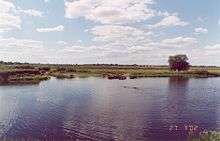
The whole area of the district belongs to the drainage basin of the Volga River. The Volga itself crosses the district from northwest to southeast, entering the Ivankovo Reservoir. The biggest tributaries of the Volga within the district are the Tvertsa River (left), which has its mouth in the city of Tver, the Shosha River (right), which crosses the southern part of the district, with the Lama River, a major tributary of the Shosha, forming a stretch of the border between Kalininsky and Konakovsky Districts, and the Soz River (left). The northeastern part of the district, northeast of Tver, is a swamp.
History
In the Middle Ages, the area belonged to Principality of Tver, and in the 14th century was, together with the principality, annexed by the Grand Duchy of Moscow. The trade route between Moscow and Veliky Novgorod crossed the area, and, in particular, Mednoye developed as a rich merchant locality on this route.[5]
In the course of the administrative reform carried out in 1708 by Peter the Great, the area was included into Ingermanlandia Governorate (since 1710 known as Saint Petersburg Governorate). In 1727 it was transferred to newly established Novgorod Governorate. In 1775, Tver Viceroyalty was formed from the lands which previously belonged to Moscow and Novgorod Governorates, and the whole area was transferred to Tver Viceroyalty, which in 1796 was transformed to Tver Governorate. The area belonged to Tverskoy Uyezd.[5]
On July 12, 1929 the governorates and uyezds were abolished. Tverskoy District, with the administrative center in Tver, was established within Tver Okrug of Moscow Oblast. On July 23, 1930, the okrugs were abolished, and the districts were directly subordinated to the oblast. On November 20, 1931 Tver was renamed Kalinin, and consequently Tverskoy District was renamed Kalininsky District. On January 29, 1935 Kalinin Oblast was established, and Kalininsky District was transferred to Kalinin Oblast.[12] During World War II, most of the area of the district was briefly occupied by German troops. By the end of December 1941, the district was back under control of the Soviet authorities.[5] In 1990, Kalinin Oblast was renamed Tver Oblast.
Another district created on July 12, 1929 was Turginovsky District, with the center in the selo of Turginovo. It was a part of Tver Okrug of Moscow Oblast. On January 29, 1935 Turginovsky District was transferred to Kalinin Oblast. On February 1, 1963 Turginovsky District was abolished and merged into Kalininsky District.[12]
On July 12, 1929 Yemelyanovsky District, with the center in the selo of Yemelyanovo was created as well. It was a part of Tver Okrug of Moscow Oblast. On January 29, 1935 Yemelyanovsky District was transferred to Kalinin Oblast. On July 4, 1956 Yemelyanovsky District was abolished and split between Kalininsky, Staritsky, Turginovsky, and Vysokovsky Districts.[12]
On March 5, 1935 Kushalinsky District with the center in the selo of Kushalino was established on the areas previously belonging to Kalininsky and Rameshkovsky Districts. On July 4, 1956 it was abolished and split between Kalininsky, Goritsky, and Rameshkovsky Districts.[12]
On March 5, 1935 Mednovsky District with the center in the selo of Mednoye was established as well on the areas previously belonging to Kalininsky, Likhoslavlsky, and Novotorzhsky Districts. On July 4, 1956 it was abolished and split between Kalininsky and Novotorzhsky Districts.[12]
On September 8, 1937 Orshinsky District with the administrative center in the selo of Rozhdestveno was established in the area which previously belonged to Konakovsky and Zavidovsky Districts. On October 22, 1959 the district was abolished and split between Konakovsky, Kalininsky, and Goritsky Districts.[12]
Administrative and municipal status
Within the framework of administrative divisions, Kalininsky District is one of the thirty-six in the oblast.[1] The city of Tver serves as its administrative center, despite being incorporated separately as an okrug—an administrative unit with the status equal to that of the districts.[9]
As a municipal division, the district is incorporated as Kalininsky Municipal District.[4] Tver Okrug is incorporated separately from the district as Tver Urban Okrug.[3]
Economy
Industry
The district has several industrial enterprises, producing plastic, copper alloys, and repairing the boat motors. Vasilyevsky Mokh is a center of peat extraction.[13]
Agriculture
The main agricultural specializations of the district are cattle breeding with meat and milk production and potato growing.[14]
Transportation

The Moscow – Saint Petersburg Railway crosses the district from southeast to northwest, passing Tver. All stations and platforms south of Tver on this line within the district are on the Leningradsky suburban direction of Oktyabrskaya Railway and are connected by regular passenger suburban service with both Moscow (Leningradsky railway station) and Tver. There is also a passenger line from Doroshikha to Vasilyevsky Mokh, however, the passenger traffic to Vasilyevsky Mokh discontinued in 2014, and the line is likely to be demolished.
The M10 highway, which connects Moscow and St. Petersburg, crosses the district from southeast to northwest. Tver is connected by roads with Bezhetsk via Rameshki, with Kimry, with Rzhev via Staritsa, and with Lotoshino by roads, all of which cross the district. There are local roads as well.
Culture and recreation

The district contains 12 cultural heritage monuments of federal significance and additionally 140 objects classified as cultural and historical heritage of local significance. The federal monuments include the ensemble of the Orsha Ascension Monastery in the village of Orsha and the ensemble of churches in the selo of Ivanovskoye, as well as the Church of Our Lady of Kazan (1764) in the selo of Mednoye, several archeological sites, and a monument commemorating Polish officers who were executed in Mednoye in 1940.[15]
There are a number of museums in the district. In Domotkanovo, in the former estate of the Derviz family, Valentin Serov, a Russian painter, stayed for extended periods, and the estate is currently a museum.[16] In the settlement of Emmaus, the house of Soviet socialist realist artist Vladimir Serov (unrelated to Valentin Serov) is preserved as a museum.[17] In Emmaus, there is also a museum of Kalinin Front.[18] In Mednoye, there is a complex commemorating Polish prisoners of war who were held in the concentration cam there and executed in 1940.[19] In the village of Knyazevo, the building of a school which the future opera tenor Sergei Lemeshev attended, is also converted into a museum.[20] In the village of Novinki, during the Revolution of 1905, the first Soviet of Peasant Deputies in Russia was formed. The building survived and is currently a museum.[21]
References
Notes
- 1 2 3 4 5 Государственный комитет Российской Федерации по статистике. Комитет Российской Федерации по стандартизации, метрологии и сертификации. №ОК 019-95 1 января 1997 г. «Общероссийский классификатор объектов административно-территориального деления. Код 28 220», в ред. изменения №259/2014 от 12 декабря 2014 г.. (State Statistics Committee of the Russian Federation. Committee of the Russian Federation on Standardization, Metrology, and Certification. #OK 019-95 January 1, 1997 Russian Classification of Objects of Administrative Division . Code 28 220, as amended by the Amendment #259/2014 of December 12, 2014. ).
- ↑ The count of urban-type settlements may include the work settlements, the resort settlements, the suburban (dacha) settlements, as well as urban-type settlements proper.
- 1 2 3 Law #4-ZO
- 1 2 Law #26-ZO
- 1 2 3 4 5 Общие сведения (in Russian). Kalininsky District administration. Retrieved 29 September 2014.
- 1 2 Russian Federal State Statistics Service (2011). "Всероссийская перепись населения 2010 года. Том 1" [2010 All-Russian Population Census, vol. 1]. Всероссийская перепись населения 2010 года (2010 All-Russia Population Census) (in Russian). Federal State Statistics Service. Retrieved June 29, 2012.
- ↑ The value of density was calculated automatically by dividing the 2010 Census population by the area specified in the infobox. Please note that this value is only approximate as the area specified in the infobox does not necessarily correspond to the area of the entity proper or is reported for the same year as the population.
- ↑ Правительство Российской Федерации. Федеральный закон №107-ФЗ от 3 июня 2011 г. «Об исчислении времени», в ред. Федерального закона №271-ФЗ от 03 июля 2016 г. «О внесении изменений в Федеральный закон "Об исчислении времени"». Вступил в силу по истечении шестидесяти дней после дня официального опубликования (6 августа 2011 г.). Опубликован: "Российская газета", №120, 6 июня 2011 г. (Government of the Russian Federation. Federal Law #107-FZ of June 31, 2011 On Calculating Time, as amended by the Federal Law #271-FZ of July 03, 2016 On Amending Federal Law "On Calculating Time". Effective as of after sixty days following the day of the official publication.).
- 1 2 Law #34-ZO
- ↑ Russian Federal State Statistics Service (May 21, 2004). "Численность населения России, субъектов Российской Федерации в составе федеральных округов, районов, городских поселений, сельских населённых пунктов – районных центров и сельских населённых пунктов с населением 3 тысячи и более человек" [Population of Russia, Its Federal Districts, Federal Subjects, Districts, Urban Localities, Rural Localities—Administrative Centers, and Rural Localities with Population of Over 3,000] (XLS). Всероссийская перепись населения 2002 года [All-Russia Population Census of 2002] (in Russian). Retrieved August 9, 2014.
- ↑ Demoscope Weekly (1989). "Всесоюзная перепись населения 1989 г. Численность наличного населения союзных и автономных республик, автономных областей и округов, краёв, областей, районов, городских поселений и сёл-райцентров" [All Union Population Census of 1989: Present Population of Union and Autonomous Republics, Autonomous Oblasts and Okrugs, Krais, Oblasts, Districts, Urban Settlements, and Villages Serving as District Administrative Centers]. Всесоюзная перепись населения 1989 года [All-Union Population Census of 1989] (in Russian). Институт демографии Национального исследовательского университета: Высшая школа экономики [Institute of Demography at the National Research University: Higher School of Economics]. Retrieved August 9, 2014.
- 1 2 3 4 5 6 Справка об изменениях в административно-территориальном делении Тверской губернии - Калининской области (in Russian). Архивы России. Retrieved 29 March 2014.
- ↑ Промышленность (in Russian). Kalininsky District administration. Retrieved 2 October 2014.
- ↑ Крестьянско-фермерские хозяйства (in Russian). Kalininsky District administration. Retrieved 2 October 2014.
- ↑ Памятники истории и культуры народов Российской Федерации (in Russian). Russian Ministry of Culture. Retrieved 2 June 2016.
- ↑ Мемориально-художественный музей Валентина Александровича Серова в Домотканове (in Russian). Российская сеть культурного наследия. Retrieved 30 September 2014.
- ↑ Мемориально-художественный музей Владимира Александровича Серова в Эммаусе (in Russian). Российская сеть культурного наследия. Retrieved 30 September 2014.
- ↑ Музей Калининского фронта (in Russian). Российская сеть культурного наследия. Retrieved 30 September 2014.
- ↑ Мемориальный комплекс "Медное" (in Russian). Российская сеть культурного наследия. Retrieved 30 September 2014.
- ↑ Музей С.Я. Лемешева (in Russian). Российская сеть культурного наследия. Retrieved 30 September 2014.
- ↑ "Дом-музей I-го Совета крестьянских депутатов" (in Russian). Российская сеть культурного наследия. Retrieved 30 September 2014.
Sources
- Законодательное Собрание Тверской области. Закон №34-ЗО от 17 апреля 2006 г. «Об административно-территориальном устройстве Тверской области», в ред. Закона №66-ЗО от 1 октября 2014 г. «О внесении изменения в статью 18 Закона Тверской области "Об административно-территориальном устройстве Тверской области"». Вступил в силу со дня официального опубликования. Опубликован: "Тверские ведомости", №17 (специальный выпуск), 19 апреля 2006 г. (Legislative Assembly of Tver Oblast. Law #34-ZO of April 17, 2006 On the Administrative-Territorial Structure of Tver Oblast, as amended by the Law #66-ZO of October 1, 2014 On Amending Article 18 of the Law of Tver Oblast "On the Administrative-Territorial Structure of Tver Oblast". Effective as of the official publication date.).
- Законодательное Собрание Тверской области. Закон №4-ЗО от 18 января 2005 г. «Об установлении границ муниципальных образований Тверской области и наделении их статусом городских округов, муниципальных районов», в ред. Закона №65-ЗО от 24 июля 2012 г. «О внесении изменения в статью 2 Закона Тверской области "Об установлении границ муниципальных образований Тверской области и наделении их статусом городских округов, муниципальных районов"». Вступил в силу через десять дней после официального опубликования. Опубликован: "Тверские ведомости", №3, 21–27 января 2005 г. (Legislative Assembly of Tver Oblast. Law #4-ZO of January 18, 2005 On Establishing the Borders of the Municipal Formations of Tver Oblast and on Granting Them the Status of Urban Okrugs, Municipal Districts, as amended by the Law #65-ZO of July 24, 2012 On Amending Article 2 of the Law of Tver Oblast "On Establishing the Borders of the Municipal Formations of Tver Oblast and on Granting Them the Status of Urban Okrugs, Municipal Districts". Effective as of the day which is ten days after the official publication.).
- Законодательное Собрание Тверской области. Закон №26-ЗО от 28 февраля 2005 г. «Об установлении границ муниципальных образований, входящих в состав территории муниципального образования Тверской области "Калининский район", и наделении их статусом городского, сельского поселения», в ред. Закона №42-ЗО от 9 июня 2009 г «О внесении изменений в Закон Тверской области "Об установлении границ муниципальных образований, входящих в состав территории муниципального образования Тверской области "Калининский район", и наделении их статусом городского, сельского поселения"». Вступил в силу со дня официального опубликования. Опубликован: "Тверские ведомости", №10, 11–17 марта 2005 г. (Legislative Assembly of Tver Oblast. Law #26-ZO of February 28, 2005 On Establishing the Borders of the Municipal Formations Comprising the Territory of the Municipal Formation of "Kalininsky District" and on Granting Them the Status of Urban and Rural Settlements, as amended by the Law #42-ZO of June 9, 2009 On Amending the Law of Tver Oblast "On Establishing the Borders of the Municipal Formations Comprising the Territory of the Municipal Formation of "Kalininsky District" and on Granting Them the Status of Urban and Rural Settlements". Effective as of the day of the official publication.).
| Cities and towns (all levels) | |||
|---|---|---|---|
| Closed administrative-territorial formations | |||
| Districts |
| ||