Zubtsovsky District
| Zubtsovsky District Зубцовский район (Russian) | |
|---|---|
 Location of Zubtsovsky District in Tver Oblast | |
| Coordinates: 56°10′N 34°35′E / 56.167°N 34.583°ECoordinates: 56°10′N 34°35′E / 56.167°N 34.583°E | |
.gif) |
.svg.png) |
|
| |
| Location | |
| Country | Russia |
| Federal subject | Tver Oblast[1] |
| Administrative structure (as of 2012) | |
| Administrative center | town of Zubtsov[1] |
| Administrative divisions: | |
| Urban settlements | 1 |
| Rural settlements | 7 |
| Inhabited localities: | |
| Cities/towns | 1 |
| Rural localities | 272 |
| Municipal structure (as of March 2011) | |
| Municipally incorporated as | Zubtsovsky Municipal District[2] |
| Municipal divisions:[3] | |
| Urban settlements | 1 |
| Rural settlements | 7 |
| Statistics | |
| Area | 2,166.5 km2 (836.5 sq mi)[4] |
| Population (2010 Census) | 17,216 inhabitants[5] |
| • Urban | 40.2% |
| • Rural | 59.8% |
| Density | 7.95/km2 (20.6/sq mi)[6] |
| Time zone | MSK (UTC+03:00)[7] |
| Official website | |
| Zubtsovsky District on WikiCommons | |
Zubtsovsky District (Russian: Зубцо́вский райо́н) is an administrative[1] and municipal[2] district (raion), one of the thirty-six in Tver Oblast, Russia. It is located in the south of the oblast and borders with Staritsky District in the north, Lotoshinsky District of Moscow Oblast in the northeast, Shakhovskoy District, also of Moscow Oblast, in the east, Gagarinsky District of Smolensk Oblast in the south, Sychyovsky District, also of Smolensk Oblast, in the southwest, and with Rzhevsky District in the west. The area of the district is 2,166.5 square kilometers (836.5 sq mi).[4] Its administrative center is the town of Zubtsov.[1] Population: 17,216 (2010 Census);[5] 19,398 (2002 Census);[8] 21,950 (1989 Census).[9] The population of Zubtsov accounts for 40.2% of the district's total population.[5]
Geography
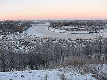
The whole area of the district belongs to the drainage basin of the Volga. The Volga itself crosses the northern part of the district. The biggest tributaries of the Volga within the district are the Derzha and the Vazuza, in the lower course together with a major tributary, the Osuga, built as Vazuza Reservoir. The northeastern part of the district belongs to the drainage basin of the Shosha, a major right tributary of the Volga. The Shosha itself crosses the eastern part of the district. The landscape of the district are primarily smooth hills.
History
Zubtsov was first mentioned in 1216.[10] Due to its location on the Volga, it controlled one of the versions of the Trade route from the Varangians to the Greeks.[11] In the 14th century, the area belonged to Principality of Tver. Between 1318 and 1460, separate Zubtsov Principality existed with the seat in Zubtsov. It was subordinate to Principality of Tver. In 1460, it was abolished and merged back to Principality of Tver. In 1485, the area was included to the Grand Duchy of Moscow.[12]
In the course of the administrative reform carried out in 1708 by Peter the Great, the area was included into Ingermanlandia Governorate (since 1710 known as Saint Petersburg Governorate), and in 1727 Novgorod Governorate split off. In 1775, Tver Viceroyalty was formed from the lands which previously belonged to Moscow and Novgorod Governorates, and the area was transferred to Tver Viceroyalty, which in 1796 was transformed to Tver Governorate. In 1775, Zubtsovsky Uyezd was established, with the center in Zubtsov. The whole area of the district belonged to Zubtsovsky Uyezd. On 30 May 1922, Zubtsovsky Uyezd was abolished and merged into Rzhevsky Uyezd.[13]
On 12 July 1929, governorates and uyezds were abolished, and Zubtsovsky District with the administrative center in the town of Zubtsov was established. It belonged to Rzhev Okrug of Western Oblast.[14][15] On August 1, 1930 the okrugs were abolished, and the districts were subordinated directly to the oblast. On 29 January 1935 Kalinin Oblast was established, and Zubtsovsky District was transferred to Kalinin Oblast.[13][14] During World War II, in 1941—1943, the district was occupied by German troops. In February 1963, during the abortive administrative reform by Nikita Khrushchev, Zubtsovsky District was merged into Rzhevsky District, but on 12 January 1965 it was re-established.[13] In 1990, Kalinin Oblast was renamed Tver Oblast.[15]
On 12 July 1929 Pogorelsky District, with the center in the selo of Pogoreloye Gorodishche was created as well. It was a part of Rzhev Okrug of Moscow Oblast. In 1934, the district was abolished. On 10 February 1935 Pogorelsky District was re-established and transferred to Kalinin Oblast. On 14 November 1960 Pogorelsky District was abolished and merged into Zubtsovsky District.[13]
Economy
Industry
There are enterprises of timber industry and of metallurgy in the district.[16]
Agriculture
The main agricultural specializations of the district are cattle breeding with meat and milk production, and crops growing.[16]
Transportation
The railroad which connects Moscow and Riga via Rzhev, crosses the district from east to west. The principal stations within the district are Zubtsov and Knyazhyi Gory.
The M9 highway connecting Moscow with Riga also crosses the district passing Zubtsov. Another road to Gagarin branches off south. There are also local roads with bus traffic originating from Zubtsov.
The Volga is navigable, however, there is no passenger navigation.
Culture and recreation
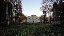
The district contains 17 cultural heritage monuments of federal significance (4 of them in Zubtsov) and additionally 103 objects classified as cultural and historical heritage of local significance (22 of them in Zubtsov). The federal monuments include the Dormition Cathedral in Zubtsov, the complex of the Stepanovskoye Estate in the selo of Volosovo, as well as a number of archeological sites and of monuments related to World War II.[17]
The Zubtsov District Museum, open in 1988 and located in Zubtsov, exhibits collections of local interest, including historical and archeological collections.[18]
References
Notes
- 1 2 3 4 Государственный комитет Российской Федерации по статистике. Комитет Российской Федерации по стандартизации, метрологии и сертификации. №ОК 019-95 1 января 1997 г. «Общероссийский классификатор объектов административно-территориального деления. Код 28 218», в ред. изменения №259/2014 от 12 декабря 2014 г.. (State Statistics Committee of the Russian Federation. Committee of the Russian Federation on Standardization, Metrology, and Certification. #OK 019-95 January 1, 1997 Russian Classification of Objects of Administrative Division . Code 28 218, as amended by the Amendment #259/2014 of December 12, 2014. ).
- 1 2 Law #4-ZO
- ↑ Law #25-ZO
- 1 2 "Информация о районе" (in Russian). Zubtsovsky District Administration. Retrieved 19 March 2015.
- 1 2 3 Russian Federal State Statistics Service (2011). "Всероссийская перепись населения 2010 года. Том 1" [2010 All-Russian Population Census, vol. 1]. Всероссийская перепись населения 2010 года (2010 All-Russia Population Census) (in Russian). Federal State Statistics Service. Retrieved June 29, 2012.
- ↑ The value of density was calculated automatically by dividing the 2010 Census population by the area specified in the infobox. Please note that this value is only approximate as the area specified in the infobox does not necessarily correspond to the area of the entity proper or is reported for the same year as the population.
- ↑ Правительство Российской Федерации. Федеральный закон №107-ФЗ от 3 июня 2011 г. «Об исчислении времени», в ред. Федерального закона №271-ФЗ от 03 июля 2016 г. «О внесении изменений в Федеральный закон "Об исчислении времени"». Вступил в силу по истечении шестидесяти дней после дня официального опубликования (6 августа 2011 г.). Опубликован: "Российская газета", №120, 6 июня 2011 г. (Government of the Russian Federation. Federal Law #107-FZ of June 31, 2011 On Calculating Time, as amended by the Federal Law #271-FZ of July 03, 2016 On Amending Federal Law "On Calculating Time". Effective as of after sixty days following the day of the official publication.).
- ↑ Russian Federal State Statistics Service (May 21, 2004). "Численность населения России, субъектов Российской Федерации в составе федеральных округов, районов, городских поселений, сельских населённых пунктов – районных центров и сельских населённых пунктов с населением 3 тысячи и более человек" [Population of Russia, Its Federal Districts, Federal Subjects, Districts, Urban Localities, Rural Localities—Administrative Centers, and Rural Localities with Population of Over 3,000] (XLS). Всероссийская перепись населения 2002 года [All-Russia Population Census of 2002] (in Russian). Retrieved August 9, 2014.
- ↑ Demoscope Weekly (1989). "Всесоюзная перепись населения 1989 г. Численность наличного населения союзных и автономных республик, автономных областей и округов, краёв, областей, районов, городских поселений и сёл-райцентров" [All Union Population Census of 1989: Present Population of Union and Autonomous Republics, Autonomous Oblasts and Okrugs, Krais, Oblasts, Districts, Urban Settlements, and Villages Serving as District Administrative Centers]. Всесоюзная перепись населения 1989 года [All-Union Population Census of 1989] (in Russian). Институт демографии Национального исследовательского университета: Высшая школа экономики [Institute of Demography at the National Research University: Higher School of Economics]. Retrieved August 9, 2014.
- ↑ Энциклопедия Города России. Moscow: Большая Российская Энциклопедия. 2003. p. 149. ISBN 5-7107-7399-9.
- ↑ "Информация о районе" (in Russian). Zubtsovsky District administration. Retrieved 8 April 2015.
- ↑ Залесский, Константин. Полный исторический атлас России (in Russian). Litres. ISBN 9785457542266.
- 1 2 3 4 Справка об изменениях в административно-территориальном делении Тверской губернии - Калининской области (in Russian). Архивы России. Archived from the original on April 19, 2012. Retrieved 1 March 2014.
- 1 2 Воробьёв, М. В. (1993). Г. В. Туфанова, ed. Административно-территориальное деление Смоленской области (in Russian). Государственный архив Смоленской области. pp. 118–133.
- 1 2 Малыгин, П. Д.; Смирнов, С. Н. (2007). История административно-территориального деления Тверской Области (PDF). Tver. pp. 14–15. OCLC 540329541.
- 1 2 "Зубцовский район" (in Russian). Parliament of Tver Oblast. Retrieved 3 April 2015.
- ↑ Памятники истории и культуры народов Российской Федерации (in Russian). Russian Ministry of Culture. Retrieved 2 June 2016.
- ↑ "Зубцовский краеведческий музей" (in Russian). «Зубцов Онлайн». Retrieved 6 April 2015.
Sources
- Законодательное Собрание Тверской области. Закон №4-ЗО от 18 января 2005 г. «Об установлении границ муниципальных образований Тверской области и наделении их статусом городских округов, муниципальных районов», в ред. Закона №65-ЗО от 24 июля 2012 г. «О внесении изменения в статью 2 Закона Тверской области "Об установлении границ муниципальных образований Тверской области и наделении их статусом городских округов, муниципальных районов"». Вступил в силу через десять дней после официального опубликования. Опубликован: "Тверские ведомости", №3, 21–27 января 2005 г. (Legislative Assembly of Tver Oblast. Law #4-ZO of January 18, 2005 On Establishing the Borders of the Municipal Formations of Tver Oblast and on Granting Them the Status of Urban Okrugs, Municipal Districts, as amended by the Law #65-ZO of July 24, 2012 On Amending Article 2 of the Law of Tver Oblast "On Establishing the Borders of the Municipal Formations of Tver Oblast and on Granting Them the Status of Urban Okrugs, Municipal Districts". Effective as of the day which is ten days after the official publication.).
- Законодательное Собрание Тверской области. Закон №25-ЗО от 28 февраля 2005 г. «Об установлении границ муниципальных образований, входящих в состав территории муниципального образования Тверской области "Зубцовский район", и наделении их статусом городского, сельского поселения», в ред. Закона №7-ЗО от 9 марта 2011 г. «О внесении изменения в Приложение №1 к Закону Тверской области "Об установлении границ муниципальных образований, входящих в состав территории муниципального образования Тверской области "Зубцовский район", и наделении их статусом городского, сельского поселения"». Вступил в силу со дня официального опубликования. Опубликован: "Тверские ведомости", №10, 11–17 марта 2005 г. (Legislative Assembly of Tver Oblast. Law #25-ZO of February 28, 2005 On Establishing the Borders of the Municipal Formations Comprised by the Territory of the Municipal Formation of "Zubtsovsky District" and on Granting Them the Status of Urban, Rural Settlements, as amended by the Law #7-ZO of March 9, 2011 On Amending Appendix 1 of the Law of Tver Oblast "On Establishing the Borders of the Municipal Formations Comprised by the Territory of the Municipal Formation of "Zubtsovsky District" and on Granting Them the Status of Urban, Rural Settlements". Effective as of the day of the official publication.).
| Cities and towns (all levels) | |||
|---|---|---|---|
| Closed administrative-territorial formations | |||
| Districts |
| ||