Staritsky District
| Staritsky District Старицкий район (Russian) | |
|---|---|
 Location of Staritsky District in Tver Oblast | |
| Coordinates: 56°31′N 34°56′E / 56.517°N 34.933°ECoordinates: 56°31′N 34°56′E / 56.517°N 34.933°E | |
.png) | |
|
| |
| Location | |
| Country | Russia |
| Federal subject | Tver Oblast[1] |
| Administrative structure (as of 2012) | |
| Administrative center | town of Staritsa[1] |
| Administrative divisions: | |
| Urban settlements | 1 |
| Rural settlements | 8 |
| Inhabited localities: | |
| Cities/towns | 1 |
| Rural localities | 416 |
| Municipal structure (as of July 2012) | |
| Municipally incorporated as | Staritsky Municipal District[2] |
| Municipal divisions:[3] | |
| Urban settlements | 1 |
| Rural settlements | 8 |
| Statistics | |
| Area | 3,005 km2 (1,160 sq mi)[4] |
| Population (2010 Census) | 24,056 inhabitants[5] |
| • Urban | 35.8% |
| • Rural | 64.2% |
| Density | 8.01/km2 (20.7/sq mi)[6] |
| Time zone | MSK (UTC+03:00)[7] |
| Official website | |
| Staritsky District on WikiCommons | |
Staritsky District (Russian: Ста́рицкий райо́н) is an administrative[1] and municipal[2] district (raion), one of the thirty-six in Tver Oblast, Russia. It is located in the central and southern parts of the oblast and borders with Kuvshinovsky District in the north, Torzhoksky District in the northeast, Kalininsky District in the east, Lotoshinsky District of Moscow Oblast in the southeast, Zubtsovsky District in the south, Rzhevsky District in the southwest, and with Selizharovsky District in the west. The area of the district is 3,005 square kilometers (1,160 sq mi).[4] Its administrative center is the town of Staritsa.[1] Population: 24,056 (2010 Census);[5] 25,765 (2002 Census);[8] 28,764 (1989 Census).[9] The population of Staritsa accounts for 35.8% of the district's total population.[5]
Geography
The whole area of the district belongs to the drainage basin of the Volga River. The Volga itself crosses the district from southwest to northeast, and the town of Staritsa is located on its banks. Rivers in the southeast of the district drain into the Shosha, a major right tributary of the Volga. A short stretch of the Shosha crosses the southwestern corner of the district. More than 50% of the area of the district is forested.[10]
History
Staritsa was founded by Prince Mikhail of Tver in 1297 as Novy Gorod (known as Staritsa since the 14th century). At the time, the area belonged to Principality of Tver. In the 14th century, it belonged to Principality of Zubtsov, which was eventually was merged back into Principlality of Tver. In 1485 it was formally annexed by the Grand Duchy of Moscow. Between 1519 and 1597 Principality of Staritsa, subordinate to Moscow, existed with the capital in Staritsa.[11]
In the course of the administrative reform carried out in 1708 by Peter the Great, the area was included into Ingermanlandia Governorate (since 1710 known as Saint Petersburg Governorate), and in 1727 Novgorod Governorate split off. In 1775, Tver Viceroyalty was formed from the lands which previously belonged to Moscow and Novgorod Governorates, and the area was transferred to Tver Viceroyalty, which in 1796 was transformed to Tver Governorate. In 1775, Staritsky Uyezd was established, with the center in Staritsa. Much of the area of the district belonged to Staritsky Uyezd. The southern part of the District belonged to Zubtsovsky Uyezd, also established in 1775. On 3 March 1924, Staritsky Uyezd was abolished and split between Novotorzhsky, Rzhevsky, and Tverskoy Uyezds.[12]
On 12 July 1929, governorates and uyezds were abolished, and Staritsky District with the administrative center in the town of Staritsa was established. It belonged to Rzhev Okrug of Western Oblast.[13][14] On August 1, 1930 the okrugs were abolished, and the districts were subordinated directly to the oblast. On 29 January 1935 Kalinin Oblast was established, and Staritsky District was transferred to Kalinin Oblast.[12][13] During World War II, in 1941—1942, a considerable part of the district, including Staritsa, was occupied by German troops. In 1990, Kalinin Oblast was renamed Tver Oblast.[14]
On 12 July 1929 Yemelyanovsky District, with the center in the selo of Yemelyanovo was created as well. It was a part of Tver Okrug of Moscow Oblast. On 29 January 1935 Yemelyanovsky District was transferred to Kalinin Oblast. On 4 July 1956 Yemelyanovsky District was abolished and split between Kalininsky, Staritsky, Turginovsky, and Vysokovsky Districts.[12]
Another district created on 12 July 1929 was Lukovnikovsky District, with the center in the selo of Lukovnikovo. It was a part of Rzhev Okrug of Western Oblast. On 29 January 1935 Lukovnikovsky District was transferred to Kalinin Oblast. On 14 November 1960 Lukovnikovsky District was abolished and split between Kirovsky, Novotorzhsky, Staritsky, and Rzhevsky Districts.[12]
On 12 July 1929 Vysokovsky District, with the center in the settlement of Vysokoye was created as well. It was a part of Rzhev Okrug of Western Oblast. In 1930, it was abolished. On 1 June 1936, the district was re-established. On 13 February 1963 Vysokovsky District was abolished and merged into Staritsky District.[12] Later, its northern part was transferred to Torzhoksky District.[14]
Economy
Industry
The two biggest enterprises of the district are located in Staritsa. One produces hydraulic devices for aviation industry, another one performs heat treatment of metal.[10]
Agriculture
The main agricultural specialization of the district is cattle breeding with meat and milk production.[10]
Transportation
A railway connecting Torzhok and Rzhev crosses the district from northeast to southwest. The biggest station within the district is Staritsa railway station, located about a dozen kilometers northeast of the town of Staritsa.
A paved road connecting Tver to Rzhev crosses the district and passes through Staritsa, where there is a bridge over the Volga. Another road connects Staritsa with Torzhok via Bernovo. There are also local roads with bus traffic originating from Staritsa.
The Volga is navigable but there is no passenger navigation.
Culture and recreation

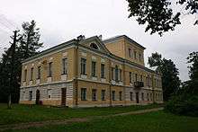
The district contains 95 cultural heritage monuments of federal significance (37 of them in Staritsa) and additionally 346 objects classified as cultural and historical heritage of local significance (121 of them in Staritsa). The federal monuments include, in particular, the ensemble of the center of the town of Staritsa (with Dormition Monastery), the Bernovo Estate in the village of Bernovo, the Transfiguration Church and the Krasnoye Estate in the village of Krasnoye, the Bratkovo-Ivanovskoye Estate in the selo of Ivanovskoye, the Pervitino Estate in the selo of Pervitino, the Chukavino Estate in the selo of Chukavino, as well as the several archeological sites.[15]
There are three museums in the district. In the town of Staritsa, the Staritsa District museum concentrates on the history of the area. In Bernovo, the Alexander Pushkin Museum is open. Alexander Pushkin, a Russian poet considered to be a creator of the modern Russian language, visited the Bernovo Estate owned by his friends on several occasions. In the village of Ryasnya, where in a nearby estate the vice-admiral Vladimir Kornilov was born, a memorial museum was opened.[10]
References
Notes
- 1 2 3 4 Государственный комитет Российской Федерации по статистике. Комитет Российской Федерации по стандартизации, метрологии и сертификации. №ОК 019-95 1 января 1997 г. «Общероссийский классификатор объектов административно-территориального деления. Код 28 253», в ред. изменения №259/2014 от 12 декабря 2014 г.. (State Statistics Committee of the Russian Federation. Committee of the Russian Federation on Standardization, Metrology, and Certification. #OK 019-95 January 1, 1997 Russian Classification of Objects of Administrative Division . Code 28 253, as amended by the Amendment #259/2014 of December 12, 2014. ).
- 1 2 Law #4-ZO
- ↑ Law #48-ZO
- 1 2 "Official site of the town of Staritsa" Check
|url=value (help) (in Russian). Administration of the town of Staritsa. Retrieved 24 February 2015. - 1 2 3 Russian Federal State Statistics Service (2011). "Всероссийская перепись населения 2010 года. Том 1" [2010 All-Russian Population Census, vol. 1]. Всероссийская перепись населения 2010 года (2010 All-Russia Population Census) (in Russian). Federal State Statistics Service. Retrieved June 29, 2012.
- ↑ The value of density was calculated automatically by dividing the 2010 Census population by the area specified in the infobox. Please note that this value is only approximate as the area specified in the infobox does not necessarily correspond to the area of the entity proper or is reported for the same year as the population.
- ↑ Правительство Российской Федерации. Федеральный закон №107-ФЗ от 3 июня 2011 г. «Об исчислении времени», в ред. Федерального закона №271-ФЗ от 03 июля 2016 г. «О внесении изменений в Федеральный закон "Об исчислении времени"». Вступил в силу по истечении шестидесяти дней после дня официального опубликования (6 августа 2011 г.). Опубликован: "Российская газета", №120, 6 июня 2011 г. (Government of the Russian Federation. Federal Law #107-FZ of June 31, 2011 On Calculating Time, as amended by the Federal Law #271-FZ of July 03, 2016 On Amending Federal Law "On Calculating Time". Effective as of after sixty days following the day of the official publication.).
- ↑ Russian Federal State Statistics Service (May 21, 2004). "Численность населения России, субъектов Российской Федерации в составе федеральных округов, районов, городских поселений, сельских населённых пунктов – районных центров и сельских населённых пунктов с населением 3 тысячи и более человек" [Population of Russia, Its Federal Districts, Federal Subjects, Districts, Urban Localities, Rural Localities—Administrative Centers, and Rural Localities with Population of Over 3,000] (XLS). Всероссийская перепись населения 2002 года [All-Russia Population Census of 2002] (in Russian). Retrieved August 9, 2014.
- ↑ Demoscope Weekly (1989). "Всесоюзная перепись населения 1989 г. Численность наличного населения союзных и автономных республик, автономных областей и округов, краёв, областей, районов, городских поселений и сёл-райцентров" [All Union Population Census of 1989: Present Population of Union and Autonomous Republics, Autonomous Oblasts and Okrugs, Krais, Oblasts, Districts, Urban Settlements, and Villages Serving as District Administrative Centers]. Всесоюзная перепись населения 1989 года [All-Union Population Census of 1989] (in Russian). Институт демографии Национального исследовательского университета: Высшая школа экономики [Institute of Demography at the National Research University: Higher School of Economics]. Retrieved August 9, 2014.
- 1 2 3 4 "Инвестиционный паспорт - Старицкий район" Check
|url=value (help) (PDF) (in Russian). Staritsky District administration. Retrieved 25 February 2015. - ↑ "История" Check
|url=value (help) (in Russian). Staritsa Town Administration. Retrieved 3 March 2015. - 1 2 3 4 5 Справка об изменениях в административно-территориальном делении Тверской губернии - Калининской области (in Russian). Архивы России. Retrieved 1 March 2014.
- 1 2 Воробьёв, М. В. (1993). Г. В. Туфанова, ed. Административно-территориальное деление Смоленской области (in Russian). Государственный архив Смоленской области. pp. 118–133.
- 1 2 3 Малыгин, П. Д.; Смирнов, С. Н. (2007). История административно-территориального деления Тверской Области (PDF). Tver. pp. 14–15. OCLC 540329541.
- ↑ Памятники истории и культуры народов Российской Федерации (in Russian). Russian Ministry of Culture. Retrieved 2 June 2016.
Sources
- Законодательное Собрание Тверской области. Закон №4-ЗО от 18 января 2005 г. «Об установлении границ муниципальных образований Тверской области и наделении их статусом городских округов, муниципальных районов», в ред. Закона №65-ЗО от 24 июля 2012 г. «О внесении изменения в статью 2 Закона Тверской области "Об установлении границ муниципальных образований Тверской области и наделении их статусом городских округов, муниципальных районов"». Вступил в силу через десять дней после официального опубликования. Опубликован: "Тверские ведомости", №3, 21–27 января 2005 г. (Legislative Assembly of Tver Oblast. Law #4-ZO of January 18, 2005 On Establishing the Borders of the Municipal Formations of Tver Oblast and on Granting Them the Status of Urban Okrugs, Municipal Districts, as amended by the Law #65-ZO of July 24, 2012 On Amending Article 2 of the Law of Tver Oblast "On Establishing the Borders of the Municipal Formations of Tver Oblast and on Granting Them the Status of Urban Okrugs, Municipal Districts". Effective as of the day which is ten days after the official publication.).
- Законодательное Собрание Тверской области. Закон №48-ЗО от 28 февраля 2005 г. «Об установлении границ муниципальных образований, входящих в состав территории муниципального образования Тверской области "Старицкий район", и наделении их статусом городского, сельского поселения», в ред. Закона №52-ЗО от 5 июля 2012 г. «О внесении изменений в Закон Тверской области "Об установлении границ муниципальных образований, входящих в состав территории муниципального образования Тверской области "Старицкий район", и наделении их статусом городского, сельского поселения"». Вступил в силу со дня официального опубликования. Опубликован: "Тверские ведомости", №10, 11–17 марта 2005 г. (Legislative Assembly of Tver Oblast. Law #48-ZO of February 28, 2005 On Establishing the Borders of the Municipal Formations Comprised by the Territory of the Municipal Formation of "Staritsky District" and on Granting Them the Status of Urban, Rural Settlements, as amended by the Law #52-ZO of July 5, 2012 On Amending the Law of Tver Oblast "On Establishing the Borders of the Municipal Formations Comprised by the Territory of the Municipal Formation of "Staritsky District" and on Granting Them the Status of Urban, Rural Settlements". Effective as of the day of the official publication.).
| Cities and towns (all levels) | |||
|---|---|---|---|
| Closed administrative-territorial formations | |||
| Districts |
| ||