Khasi and Jaintia Hills
| Khasi-Jaintia Hills | |||||
| District of Assam Province, British India | |||||
| |||||
 | |||||
| History | |||||
| • | Bifurcation of Eastern Bengal and Assam | 1912 | |||
| • | Independence of India | 1947 | |||
| Area | |||||
| • | 1901 | 15,947 km2 (6,157 sq mi) | |||
| Population | |||||
| • | 1901 | 197,904 | |||
| Density | 12.4 /km2 (32.1 /sq mi) | ||||
| | |||||
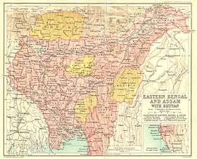
The Khasi and Jaintia Hills are a mountainous region that was mainly part of Assam and meghalaya.The Assam Legislative Assembly This area is now part of the present Indian constitutive state of Meghalaya(formerly Assam), which includes the present districts of East Jaintia Hills district, headquarter Khliehriat, West Jaintia Hills district, headquarter Jowai, East Khasi Hills district, headquarter Shillong, and West Khasi Hills district, headquarter Nongstoin.[1]
Jaintia Hills
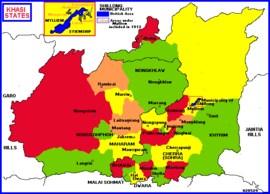
The Jaintia Hills are located further to the east from the Khasi Hills. The twelve Chiefs of the elaka (tribal province) of the Jaintia, a Khasi subtribe of the) Pantars = Syntengs tribes, are styled Dolloi, and the land is called after them in Khasi: KA RI KHADAR DOLLOI ‘Land of 12 Tribal Chiefs‘) - they are in Nartiang itself (see the Raja, uniquely also styled, as premier Chief: U Kongsong), and in Amwi, Jowai, Lakadong, Mynso, Nongbah, Nongjngi, Nongphyllut, Nongtallang, Raliang, Shangpung, Sutnga (see below; also cited as seat of a Syiem)
Above them is the only true princely ruler of the area, the Raja of Jaintiapur. His winter capital is now in Bangladesh, with his summer residence shifted from Sutnga (where the family started as Syiems) to Nartiang; also a palace in the commercial center Borghat.
The Jaintia Hills used to be a part of the Jaintia Hills District. The district has been bifurcated into two separate districts,namely, East Jaintia Hills and West Jaintia Hills on 31st July 2012.
Khasi Hills
The Khasi Hills are located east of the Garo Hills. The other Khasi tribes did not have princes but their twenty petty states (hima), and sometimes even smaller tribal divisions, are led by one or two Chiefs -selected in various ways- usually styled Siem, Syiem.[2]
The names of these chieftainships are: Bhawal, Cherra (or Sohra; capital Cherrapunji), Dwara (capital Hat Dwara), Jirang, Khyrim, Langrin, Lungiong, Maharam, Malai Sohmat, Marriw, Mawdon, Mawiang, Mawlong, Mawphlang, Mylliem (including Shillong city, the colonial capital of all Tribal Assam), Nobosohphoh, Noglwai, Nongkhlaw, Nongspung, Nongstoin, Pamsanggut, Rambrai, Shella, Sohiong. or Sardar ...
References
- ↑ Integration of the North East: the State Formation Process
- ↑ Great Britain India Office. The Imperial Gazetteer of India. Oxford: Clarendon Press, 1908.