Comilla District
| Comilla কুমিল্লা জেলা | |
|---|---|
| District | |
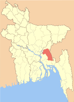 Location of Comilla in Bangladesh | |
| Coordinates: BD 23°16′N 91°07′E / 23.27°N 91.12°ECoordinates: BD 23°16′N 91°07′E / 23.27°N 91.12°E | |
| Country |
|
| Division | Chittagong Division |
| Capital | Comilla |
| Area | |
| • Total | 3,146.30 km2 (1,214.79 sq mi) |
| Population (2011 census)[1] | |
| • Total | 5,387,288 |
| • Density | 1,700/km2 (4,400/sq mi) |
| Time zone | BST (UTC+6) |
Comilla (Bengali: কুমিল্লা জেলা, Comilla Jela also Comilla Zila) is a district of Bangladesh located about 100 kilometers south east of Dhaka. Comilla is bordered by Brahmanbaria and Narayanganj districts to the north, Noakhali and Feni districts to the south, Tripura of India to the east, and Munshiganj and Chandpur districts to the west.
History
The district was renamed Comilla in 1960.[2] Established as the Tippera or Tipperah district of Bengal by the British in 1790,[3] it included the Sub-divisions of Brahmanbaria and Chandpur which eventually became separate districts in 1984. Comilla district is located in the south eastern part of Bangladesh. The naming of Comilla is debatable by historians. But among the current opinions fairly acceptable opinion found in the travel Writing of Chainik traveler “Wang Choang” when he traveled the Samtat state. In his description we found a name “Kiamolonkia” that turned into Comilla. A large portion of historians accept the opinion. The Comilla region was once under the ancient Samatat state and next included in Tripura State
Geography and climate
Comilla has a total area of 3085.17 square kilometers. It is bounded by Burchiganj and Tripura on the north, Laksham and Chauddagram on the south, and Barura on the west. Major rivers passing through Comilla include the Gumti and the Little Feni.
Administrative headquarters
The administrative headquarters of Comilla are located in the city of Comilla which has a total area of 11.47 square kilometers. It consists of 18 mouzas and 3 wards. Comilla thana was officially converted into an upazilla in 1983 which contains one municipality 18 wards, 19 union parishads, 452 mouzas and 458 villages.
Administration
Administrator of Zila Parishad: M. Omar Faruque
Deputy Commissioner (DC): Md. Rezaul Ahsan
Subdistricts
Comilla district consists of the following Upazilas:[4]
- Barura Upazila
- Brahmanpara Upazila
- Burichong Upazila
- Comilla Sadar Upazila
- Comilla Sadar Dakshin Upazila
- Chandina Upazila
- Chauddagram Upazila
- Daudkandi Upazila
- Debidwar Upazila
- Homna Upazila
- Laksam Upazila
- Monohorgonj Upazila
- Meghna Upazila
- Muradnagar Upazila
- Nangalkot Upazila
- Titas Upazila
Economy
Mainly based on agriculture, the economy of Comilla has been flourished through trade and cottage industries, especially the 'Khadi' textile. For the economic development of the region the "Bangladesh Export Promotion Zone Authority" has established the "Comilla Export Processing Zone" spread over an area of 104.44 hectares (258.1 acres) in the Comilla old Airport Area.
Places of interest
Important landmarks include Kotbari, a cantonment, or military installation and Kandirpar, considered the heart of the Comilla district. Ancient Buddhist monastery ruins are the major attraction of Mainamati, near Kotbari. There is an ancient Hindu Temple named Comilla Jagannath Temple located on East Bibirbazar Road.
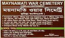
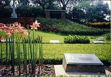
There is a Second World War cemetery located about 3.1 kilometres (1.9 mi) away from Comilla Cantonment, which was a frontier military base in the fight against the Japanese who had occupied Burma. British Army soldiers killed during the fight with the Japanese Army at the Burma (Myanmar) frontier were buried here. Pashchimgaon Nawab Bari, the place of only lady Jaminder Nawab Faizunnesa, a poet, educationist and a great donor.
Kazi Nazrul Islam, the national poet of Bangladesh, passed a significant time of his life in this town. Both his wives, Promila Devi and Nargis, hailed from this district.
Comilla Victoria College and Comilla Zilla School are two ancient and famous college and school in the country. Comilla Zilla School was established in the year of 1837. Bangladesh Academy for Rural Development (BARD) is situated in Kotbari.
Situated by the bank of the river Ghumti, Comilla is also famous for some tanks such as 'Dharmasagar (Pond)', 'Ranir Dighi', 'Nanuar Dighi', 'Ujir Dighi' etc.
Notable people
The following personalities were either born or stayed in this district for a significant span of their life time:
- Nawab Faizunnesa Choudhurani (1834–1903): poet & philanthropist.
- Kazi Zafar Ahmed: EX: Prime Minister
- Shilvadra (529-654): a great Buddhist monk & pundit, professor & chancellor of Nalanda University. Born in Koilain, Chandina Upazila of Comilla.
- Dhirendranath Datta (1886–1971): Political leader, provincial minister of the than East Pakistan, Language Movement activist & lawyer.
- Buddhadeb Basu (1908–1974): Bengali poet, novelist, essayist, translator & editor.
- Sachin Dev Burman (1906–1975): Singer, composer & music director.
- Khondaker Mostaq Ahmad (1919–1996): Ex-president of Bangladesh.
- Akhtar Hameed Khan (1914–1999): Social reformer and Development activist.He is from U.P -undivided India, but spent an important part of his life as Asst Magistrate (ICS) and thereafter as Principal Victoria College and creater of Co-operative programme and BARD at Comilla.
- Shib Narayan Das: The designer of first national flag of Bangladesh in 1971, a freedom fighter & political activist.
- Sabitri Chatterjee: Actress in Indian Bengali film, TV serial and theatre.
- Akbar Hossain BP: Ex-Minister of Bangladesh Government.
- Kazi Shamsul Hoquen eminent journalist, founder editor of weekly Akhon Samoy, New York.
- Abdul Gani: (1919-November 11, 1957) was a Bengali military officer. He was the founder and the first in-charge of one of the Pioneer Companies of 1st East Bengal Regiment.
- Abul Manzoor, Sector Commander during Bangladesh War of Independence and decorated with the award Bir Uttom, was born in Comilla.
References
- ↑ "Population and Housing Census 2011" (PDF).
- ↑ Siddiqi, Mamun (2012). "Comilla District". In Islam, Sirajul; Jamal, Ahmed A. Banglapedia: National Encyclopedia of Bangladesh (Second ed.). Asiatic Society of Bangladesh.
- ↑ Bengal District Gazetteer, Tipperah District - 1933
- ↑ Upazilas of Comilla. Bangladesh Government.
External links
| Wikimedia Commons has media related to Comilla District. |
| Barisal Division | 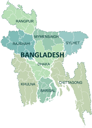 | |
|---|---|---|
| Chittagong Division | ||
| Dhaka Division | ||
| Khulna Division | ||
| Mymensingh Division | ||
| Rajshahi Division | ||
| Rangpur Division | ||
| Sylhet Division | ||