Kiambu County
| Kiambu County | |
|---|---|
| County | |
|
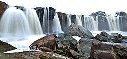
The Fourteen Falls | |
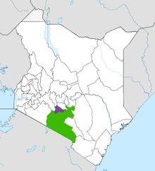
 Location in Kenya | |
| Country |
|
| Formed | March 4th 2013 |
| Capital | Kiambu |
| Government | |
| • Governor | William Kabogo |
| Area | |
| • Total | 2,449.2 km2 (945.6 sq mi) |
| Population (2009) | |
| • Total | 1,623,282 [1] |
| Time zone | EAT (UTC+3) |
| Website | kiambu.go.ke |
Kiambu County is a county in the former Central Province of Kenya. Its capital is Kiambu and its largest town is Thika. The county is adjacent to the northern border of Nairobi County and has a population of 1,623,282.[1] Its governor is William Kabogo. The county is 40% rural and 60% urban owing to Nairobi's consistent growth Northwards. Kikuyu are the dominant tribe in the county.
In 2007, Kiambu District was subdivided in two: Kiambu East and Kiambu West. Kiambu West district took Limuru, Lari and Kikuyu divisions,[2] with Limuru as its district capital.
Local authorities
| Authority | Type | Population* | Urban pop.* |
|---|---|---|---|
| Kiambu | Municipality | 72,139 | 13,814 |
| Limuru | Municipality | 70,765 | 4,141 |
| Karuri | Town Council | 100,506 | 19,746 |
| Kikuyu | Town Council | 165,594 | 4,104 |
| Ruiru | Municipality | 100,457 | 10,104 |
| Thika | Municipality | 200,500 | 25,647 |
| * 1999 census. Source: | |||
Administrative divisions
| Division | Population* | Urban pop.* | Headquarters |
|---|---|---|---|
| Githunguri | 136,554 | 8,831 | Githunguri |
| Kiambaa | 188,055 | 22,861 | Kiambu |
| Kikuyu | 194,521 | 3,724 | Kikuyu |
| Lari | 111,302 | 0 | |
| Limuru | 113,578 | 3,708 | Limuru |
| * 1999 census. Sources: , | |||
Constituencies/Sub Counties
The county has twelve constituencies/Sub counties:
- 1. Githunguri
- 2. Kiambaa
- 3. Kabete
- 4. Limuru
- 5. Lari
- 6. Gatundu North
- 7. Gatundu South
- 8. Ruiru
- 9. Kikuyu
- 10.Juja
- 11.Thika
- 12.Kiambu
Nairobi Metro
Kiambu County is within Greater Nairobi which consists of 4 out of 47 counties in Kenya but the area generates about 60% of the nations wealth.[4][5] The counties are:
| Area | County | Area (km2) | Population Census 2009 | Cities/Towns/Municipalities in the Counties |
|---|---|---|---|---|
| Core Nairobi | Nairobi County | 694.9 | 3,138,369 | Nairobi |
| Northern Metro | Kiambu County | 2,449.2 | 1,623,282 | Kiambu, Thika, Limuru, Ruiru, Karuri, Kikuyu |
| Southern Metro | Kajiado County | 21,292.7 | 687,312 | Kajiado, Olkejuado, Bissil, Ngong, Kitengela, Kiserian, Ongata Rongai |
| Eastern Metro | Machakos County | 5,952.9 | 1,098,584 | Kangundo-Tala, Machakos, Athi River |
| Totals | Nairobi Metro | 30,389.7 | 6,547,547 |
Source: NairobiMetro/ Kenya Census
Stats
Nairobi Metro
Urbanisation
| County | Urbanisation in Nairobi Metro (Percent) | ||||||||
|---|---|---|---|---|---|---|---|---|---|
| Nairobi County | 100 | ||||||||
| Kiambu County | 60.8 | ||||||||
| Machakos County | 52 | ||||||||
| Kajiado County | 41.4 | ||||||||
| |
32.3 | ||||||||
|
Urbanisation by County within Nairobi Metro | |||||||||
Source: OpenDataKenya
Wealth/Poverty Level
| County | Poverty Level in Nairobi Metro (Percent) | ||||||||
|---|---|---|---|---|---|---|---|---|---|
| Kajiado County | 11.6 | ||||||||
| Kiambu County | 21.8 | ||||||||
| Nairobi County | 22 | ||||||||
| Machakos County | 59.6 | ||||||||
| |
45.9 | ||||||||
|
Poverty level by County | |||||||||
Source: OpenDataKenya Worldbank
Central Kenya Region
Urbanisation
| County | Urbanisation in Central Kenya (Percent) | ||||||||
|---|---|---|---|---|---|---|---|---|---|
| Kiambu County | 60.8 | ||||||||
| Nyeri County | 24.5 | ||||||||
| Nyandarua County | 18.5 | ||||||||
| Muranga County | 16.3 | ||||||||
| Kirinyaga County | 15.8 | ||||||||
| |
32.3 | ||||||||
|
Urbanisation by County in Central Kenya | |||||||||
Source: OpenDataKenya
Wealth/Poverty Level
| County | Poverty Level in Central Kenya (Percent) | ||||||||
|---|---|---|---|---|---|---|---|---|---|
| Kirinyaga County | 25.2 | ||||||||
| Muranga County | 28.5 | ||||||||
| Kiambu County | 28.9 | ||||||||
| Nyeri County | 32.7 | ||||||||
| Nyandarua County | 46.6 | ||||||||
| |
45.9 | ||||||||
|
Poverty level by County | |||||||||
Source: OpenDataKenya Worldbank
See also
References
- 1 2 "Kenya Census 2009". scribd.com. Retrieved 20 June 2016.
- ↑ "Kiambu District now split into two", Kenya Broadcasting Corporation, 19 February 2007
- ↑ "County Government of Kiambu - Home". web.archive.org. Retrieved 20 June 2016.
- ↑ http://196.200.27.243:8080/xmlui/bitstream/handle/123456789/111/Nairobi.pdf?sequence=3
- ↑ http://www.nairobimetro.go.ke/index.php?option=com_docman&task=doc_download&gid=43&Itemid=90.
Nairobi metropolitan area | ||
|---|---|---|
Population - 7.8 million | ||
| Counties |  | |
| Major city 3.8 million | ||
| Urban Centres over 200K | ||
| Other major Urban Centres | ||
| Future developments | ||
Coordinates: 1°10′S 36°50′E / 1.167°S 36.833°E