Vihiga County
Not to be confused with Vihiga.
| Vihiga County | ||
|---|---|---|
| County | ||
| ||
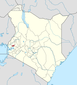 Location in Kenya | ||
| Country |
| |
| Formed | March 4th 2013 | |
| Capital | Vihiga | |
| Government | ||
| • Governor | Moses Akaranga | |
| Area | ||
| • Total | 531.3 km2 (205.1 sq mi) | |
| Population (2009) | ||
| • Total | 554,622 [1] | |
| Time zone | EAT (UTC+3) | |
| Website | vihiga.go.ke | |

Vihiga County is an administrative region in the former Western Province of Kenya whose headquarters is at Vihiga, the largest town in the county. The county has a population of 554,622 [1] (2009 census) and an area of 563 km².[2] Vihiga County was split from Kakamega County in 1990.
Local authorities
| Authority | Type | Population* | Urban pop.* |
|---|---|---|---|
| Vihiga | Municipality | 98,189 | 19,067 |
| Luanda | Town | 68,157 | 8,757 |
| Vihiga county | County | 332,537 | 0 |
| * 1999 census. Source: | |||
Administrative divisions
| Division | Population* | Urban pop.* | Headquarters |
|---|---|---|---|
| Emuhaya | 69,250 | 0 | |
| Luanda | 92,462 | 8.016 | Luanda |
| Sabatia | 117,863 | 10.135 | |
| Tiriki East | 59,943 | 0 | |
| Tiriki West | 76,370 | 0 | |
| Vihiga | 82,995 | 6.881 | Vihiga |
| * 1999 census. Sources: , , | |||
Constituencies
The district has five constituencies:
- Emuhaya Constituency
- Hamisi Constituency
- Sabatia Constituency
- Vihiga Constituency
- Luanda Constituency, with Chris Omulele (ODM) as its current M.P., who garnered 9,767 votes against his closest competitor Apungu, who got 6,588 votes (March 2013 Elections).
References
External links
Coordinates: 0°4′N 34°40′E / 0.067°N 34.667°E
This article is issued from Wikipedia - version of the 7/21/2016. The text is available under the Creative Commons Attribution/Share Alike but additional terms may apply for the media files.