Kisii, Kenya
| Kisii, Kenya | |
|---|---|
| City | |
 Kisii, Kenya | |
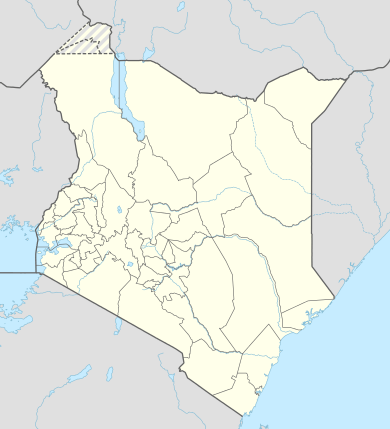
| Coordinates: 0°41′S 34°46′E / 0.683°S 34.767°E | |
| Country |
|
| County | Kisii County |
| Area | |
| • City | 10 km2 (4 sq mi) |
| • Metro | 29 km2 (11 sq mi) |
| Elevation | 1,700 m (5,577 ft) |
| Population (2009 ) | |
| • City | 200,000 |
| • Density | 2,862/km2 (7,410/sq mi) |
| • Urban | 103,000 |
| • Metro | 97,000 |
| Time zone | EAT (UTC+3) |
| Area code(s) | 058 |

Kisii is a town in south-western Kenya. It is the main urban and commercial center in the Gusii Highlands and the South Nyanza region. A vibrant town, the Kisii municipality has a population of about 300,000, according to 2012 estimates. It has a large dependent metropolitan population of over 100,000 residents, as per the latest national population and housing census of 2009. Kisii town is the capital of the Kisii County. It was the headquarters of the original and larger Kisii District before it was split to create Nyamira District (in the north) and Gucha District (in the south). With the new Kenya Constitution in August 27, 2010, Gucha District was re-absorbed back into Kisii County, whereas Nyamira District has been renamed Nyamira County.
Today, it is a bustling town and a home to several businesses, organizations, educational institutions and government agencies. Kisii municipality sits right at the centre of the western Kenya tourist circuit that includes the Tabaka Soapstone Carvings, Maasai Mara Game Reserve, Lambwe Valley Game Reserve and the entire Lake Victoria basin. The town continues to serve these former districts, the larger South Nyanza County and the Trans Mara area of western Narok County in commerce.
History
Kisii town was originally known by the Gusii people as Getembe. It was later nemed Bosongo,and it is believed to have originated from 'Abasongo' (to mean the White people or Whites) who lived in the town during the colonial times. The town was originally established by British soldiers who were being forced to retreat from Lake Victoria by heavy gunfire from German soldiers' gunboats during the Great War in the early 20th century. Later Kisii was chosen to be the District Headquarters of the larger South Nyanza and Kisii region.

Demographics
The town is predominantly inhabited by the Gusii community (also known as the Kisii), a Bantu people. The Luo, Luhya, Kuria, Asian and Kalenjin make up a minority of residents.
Population statistics
The population of Kisii town is currently at 200,000. It is the second most populous town in Nyanza after Kisumu. Kisii town is the eighth most populous town in Kenya.
Among Kenya's urban areas, Kisii municipality has a relatively high population density. However, the population density at 2,862 per km2 is relatively high owing to the scarcity of land in the municipality boundaries spurring further expansion of settlement in the outlying area. These alternative settlements have been sanctioned by the municipal government which, in turn, has allowed residents to develop their homes just outside the municipality boundary to alleviate this phenomenon.
Economy
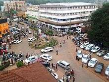
The economy of Kisii town is derived from commerce and agriculture. Crops and fruit cultivated around the area include maize, managu, beans, bananas, pineapples, avocados, pawpaws etc. Kisii town is dotted with tall commercial buildings and is ever-bustling with activity. Kisii is the fastest growing town in western Kenya thanks mainly to its high population, political stability and general tranquility. New businesses are steadily being installed.
Smaller components are in food processing, health care, education. Although it has are few industrial activities, it has potential for larger agro-based industries due to its location in a rich agricultural area. Soapstone quarrying takes place near the town around Tabaka, southwest of the town and a few miles off the Kisii-Isebania Road. Coca-Cola has a bottling and distribution plant in Kisii municipality. The town hosts large supermarket chain stores, e.g., Uchumi, Nakumatt Naivas and Tusky's. Besides, it hosts 19 commercial banking and financial institutions' branches. These include the long-existing
- Kenya Commercial Bank (KCB)
- Barclays Bank
- National Bank
- Post Bank
- Co-operative Bank (two branches)
Newer entrants in the banking sector such as Equity Bank, I&M Bank, CFC Stanbic, Credit Bank, Kenya Women Finance Trust, Family Bank, Chase Bank, Eco-Bank, Diamond Trust Bank, K-Rep Bank and others have launched new branches taking advantage of the large population and the positioning of Kisii as an increasing commercial hub town. Mwalimu Cooperative Savings & Credit Society Limited (Mwalimu Sacco), the largest Sacco in Kenya, maintains a branch in Kisii.
Moreover, like many of Kenya's major urban centers, there is an influx of numerous other business ventures such as the hospitality sector with hotels, bars, restaurants, sports pubs, among other commercial activities.
Government
The Kisii County Government runs the town. It is headed by Hon. James Ongwae, the elected governor of Kisii County, and serves as the county headquarters. The town hosts a large county government campus office, County Law Courts, Ministry offices, State Law Office branch, among other governmental installations.
Geography and transportation

Kisii is located in western Kenya, on latitude: 0° 41' 0 S and longitude: 34° 46' 0 E. The town is a driving distance of 309 km (192 mi) from the capital city of Nairobi, located east-southeast, on Class B3 all-weather road. Other major urban center's distances from Kisii town are Kisumu City which is 114 km (71 mi) to the northwest; Nyamira at 23 km (14 mi) to the immediate north; Keroka at 25 km (16 mi) to the east; Kericho at 101 km (63 mi) to the northeast; Kilgoris at 46 km (29 mi) to the southeast; Narok at 165 km (103 mi) to the east; and Migori to the south-west 67 km (42 mi) which otherwise connects the town to the Kenya /Tanzania border at Isebania town a further 31 km (19 mi) south.
Public transportation, which is operated privately, is available throughout the town. A good example is private-owned taxis (matatus), taxi cabs and 'boda-boda' (motorcycle taxis) as an alternative to privately owned vehicles. Kisii town has one of the most organized bus stations and public transport systems in the country. Buses and matatus are not allowed inside the town.
Air service to Kisii is minimal. However, chartered flights mainly from Nairobi's Wilson Airport transport passengers to Kisii's Suneka Airstrip situated 9 km (6 mi) southwest of the town centre. The facility is underused, but many of the residents especially businessmen, local politicians, and tourists use it for convenience.
From Kisii, it is easy to get to Tabaka Soapstone quarries, the Maasai Mara Game Reserve in Narok County, Lambwe Valley Game Reserve in Homa Bay County, Kisumu, Lake Victoria, and the Kenya/Tanzania or Kenya/Uganda border points.
Climate
Kisii town enjoys a highland climate. It generally receives rain all year round thanks to its positioning in the Lake Victoria lake basin and the heavily foliaged Kisii highlands. Due to its unique positioning within hills, Kisii town has never experienced flooding.
The city frequently receives thunderstorms, and some thirty people in Kisii die each year from lightning strikes because of their frequency and because many of the area's structures have metal roofs.[1]
Arts
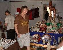
Soapstone carving is the predominant craft in Kisii. Kisii town is home to the best soapstone carvers in the continent. Their products are very popular in Europe and USA. Kisii is a favorite stopover for tourists who want a taste of the exquisite Kisii carvings. Kisii town is also the venue for the annually held Gusii Cultural Festival, an event focusing on the cultural heritage of the Gusii community.
Sports

Football (soccer) of national league status is played at Gusii Stadium and other surrounding grounds. Shabana Football Club is based in Kisii town; it has been a popular soccer club in Gusiiland and has featured in the Kenya national premier league for many years. Formed by V. Dogo Khan, the proprietor of Shabana Hardware Stores as an incentive to his store employees in the mid-1980s, it grew to be a strong football team which in its successful run, attracted and recruited star players from local high schools and talented individual players living or working in the municipality. However, its team performance has lately be relegated down to national 2nd Division league after losing most of its star players to other local and international teams for economic reasons.
Track sports such as athletics meetings are popular with the town's residents and Gusiiland in general. Such meetings are held during schools' and colleges' sports season in mid year. Other sports in town include volleyball, basketball and netball which attract a diverse participation. Gusii Stadium has been a popular venue for these meetings for many years. Lastly, golf is mainly played by middle- or upper-income residents who are members of the Kisii Golf & Sports Club, a private members' club in the municipality. This trend is one of the remnants of a tradition that was borrowed from former British settlers by the emerging Kenyan Africa-educated and elite. Many towns in the nation host vast golf courses; Kisii is one of them.
Media
There are three major radio broadcasting stations that air in the Ekegusii language; Egesa Fm which is owned by the Royal Media house. This radio station broadcasts purely in the Ekegusii language and is on air 24/7. Another Ekegusii broadcasting station is Minto Fm which was established by the Kenya Broadcasting Corporation in 2011.Also, there is one major radio station that enjoys the monopoly of airing both locally and internationally through internet streaming and toll free phone number. The Abagusii Global Radio enjoys listener ship globally.
Religion and charity
Kisii residents are predominantly Catholics and Protestants. The majority of residents identify with the Seventh Day Adventist (SDA) Church and the Roman Catholic Church. Others identify themselves with the Lutheran Church, Pentecostal Assemblies of God (PAG) Church, evangelical and inter-denominational congregations such as Redeemed or Full Gospel Church of Kenya. Recently built is a Kingdom Hall of Jehovah's Witnesses. Kisii municipality town suitable for local congregations to meet or for hosting larger annual meetings. The town has a mosque for the Muslim faithful as well as a small temple for the Hindu faithful. Both of these constitute the minority religions of the municipality's population.
There are locally-based and internationally-based non-governmental (NGO) and philanthropic organizations in the urban area. These aid organizations mainly target the needy but bright or economically poor students who seek help to further their studies in schools and colleges.
Health and utilities
Kisii Teaching and Referral Hospital (Level 6) is the largest government-owned health facility in the county. The town has reputable private hospitals and medical centers. These include Hema Hospital, Getembe Hospital, Christa Marianne Hospital, Nyangena Hospital, Bosongo Medical Center, Ram Hospital and the Agha khan hospital being one of the new ones opened serving the municipality and the county in general.
Education
Universities based in Kisii town include:
- Kisii University
- Jomo Kenyatta University of Science & Technology
- University of Nairobi
- Narok University
- Moi University
- Mount Kenya University
- Africa Nazarene University
- Nairobi Aviation college
Colleges within the town are Gusii institute of Technology, Kenya Institute of Management, Kisii College of Accountancy, St.Annes college, Nyanchwa Teacher's College, Intraglobal College, etc.
Secondary schools in the municipality and outlying areas include Kisii High School, Kereri Girls' High School, Our Lady of Lourdes Girls' High School, Nyabururu, Cardinal Otunga High School Mosocho, St. Mary's Mosocho, Itierio Boys High School, Itierio Girls High School, Suneka Secondary School, Nyanchwa High School, Daraja Mbili High School, and Kioge Girls' High School, among many others.
Notable private schools such as Sakagwa School, Rehema Schools, Genesis Preparatory, Set Green Hill, AIC, Gusii Highlights Academy, Imperial Primary School are in this city. Municipal schools such as the vintage Kisii Primary School, Jogoo Primary School, Nyanchwa Primary, Getembe Primary are based in the town.
Housing conditions
Due to the hilly topography and the frequent rains, the town lacks effective drainage systems. The only sewerage formerly in the Daraja Mbili area has been moved to Suneka area.
There is an acute shortage of land and most of its suburbs have developed without proper planning. However, aside from the existing housing estates owned by the municipality and private owned homes, there are new housing estates coming up in Nyanchwa neighborhood owned by the government's housing agency. Many residents owning private homes and flats can be found all over the municipality and its precinct areas such as organized suburbs or municipality wards such as Milimani, Gesonso, Itierio, Nyangena, Nyamataro, Mwembe Tayari, Gekomu, Menyinkwa, Nyabururu, Embassy and Nyanchwa. These are regarded as middle- to upper-middle-class neighborhoods with many modern private homes on freehold areas and apartments. The lower- to middle-class neighborhoods and outlying residential areas include Suneka, Jogoo, Getare, Menyinkwa and Nyankongo which entail a large and diverse population.
Most of all, the main reason for the few housing estates in the municipality limits is scarcity of land and many residents' preference for owner-occupancy homes over purchasing flats or homes built by the government or the municipality. The settlements consist of regular village homes as well more organized modern suburban and freehold homes. The effects of the post-election violence of 2007-8 contributed lately to the rise of private home construction and migration of residents from other major cities and towns such as nearby Kisumu, Kericho, Sotik, and as further away as Eldoret, Kitale and Nakuru. This situation encouraged a mass exodus from these towns and diaspora residents fleeing persecution fearing intertribal stigmatization into the town for their own safety. Kisii town and municipality was calm during this tumultuous period, except for the border market centers such as Chebilat in the east and Nyangusu in the southeast.
Recreation
Kisii Library, a branch of the national library system, serves the residents. It is near the center of the town opposite the county government office.
For sports lovers, the Gusii Stadium is the venue for scheduled Kenya Premier League (KPL) soccer tournaments and locally organized sporting events, The Kisii Golf Course & Sports Club for lovers of golf and relaxation. The town has other avenues for entertainment and leisure.
The town boasts a very diverse collection of country or garden hotels, e.g.:
- Kisii Hotel
- Zonic Hotel
- Storm Hotel
- Nile Restaurant
- Bluu Nile Restaurant
- Ufanisi Resort
- Mwalimu International Hotel
- The Stevens Hotel.
- Mash Park Hote
- Dados Hotel
It has numerous bars and sports pubs. The most popular are Dallas Pub, Lisbon Pub, Secrets, Jazz Pub, Rockers, Buddy's Bar 'n' Grill,Keiko, Havvana,Backyard club among others.
Parks
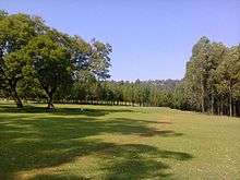
A portion of larger Kisii Golf Club's course was open for public recreation by the local authority for a couple of years. This area was later consolidated back to the golf course. Immediate availability of land for commercial or residential development has been the greatest challenge facing its longtime residents and potential investors. Lately, this impediment has been addressed by the local authority.
Kisii Golf has experienced major challenges from encroachment through illegal farming activities. The area has no fencing and the public uses it as a through way towards their residential areas. As a result, the area has been degraded, cases of insecurity have been reported, there is prostitution at night among other social challenges.
The Kisii Sports Club which claims to have responsibility of managing the golf has failed to put adequate and viable legislation to govern the green space. Students who survey the area to gather important information are harassed by the officers and threatened to appear before the court as a way of asking them to give bribes. This is a public open space, and it should not be used for special interests.
References
- ↑ National Geographic Almanac of Geography (2005), ISBN 0-7922-3877-X, page 78.
External links
| Wikivoyage has a travel guide for Kisii. |
- Ekegusii language
- Kisii website Unofficial Private Site
- Kisii town & Kenya
- Kisii population stats
Coordinates: 0°41′S 34°46′E / 0.683°S 34.767°E