Kilmacolm
| Kilmacolm | |
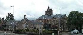 Kilmacolm centre from the Cross |
|
 Kilmacolm |
|
| Population | 4,000 (village) |
|---|---|
| OS grid reference | NS365695 |
| – Edinburgh | 56 mi (90 km) |
| – London | 355 mi (571 km) |
| Civil parish | Kilmacolm |
| Council area | Inverclyde |
| Lieutenancy area | Renfrewshire |
| Country | Scotland |
| Sovereign state | United Kingdom |
| Post town | KILMACOLM |
| Postcode district | PA13 |
| Dialling code | 01505 |
| Police | Scottish |
| Fire | Scottish |
| Ambulance | Scottish |
| EU Parliament | Scotland |
| UK Parliament | Inverclyde |
| Scottish Parliament | Renfrewshire North and West |
Coordinates: 55°53′39″N 4°37′37″W / 55.894103°N 4.62708°W
Kilmacolm (![]() i/ˌkɪlməˈkoʊlm/) is a village and civil parish in the Inverclyde council area and the historic county of Renfrewshire in the west central Lowlands of Scotland. It lies on the northern slope of the Gryffe Valley 7 1⁄2 miles (12.1 km) south-east of Greenock and around 15 miles (24 km) west of the city of Glasgow. The village has a population of around 4,000 and is part of a wider civil parish which covers a large rural hinterland of 15,000 hectares (150 km2; 58 sq mi) containing within it the smaller settlement of Quarrier's Village, originally established as a 19th-century residential orphans' home.
i/ˌkɪlməˈkoʊlm/) is a village and civil parish in the Inverclyde council area and the historic county of Renfrewshire in the west central Lowlands of Scotland. It lies on the northern slope of the Gryffe Valley 7 1⁄2 miles (12.1 km) south-east of Greenock and around 15 miles (24 km) west of the city of Glasgow. The village has a population of around 4,000 and is part of a wider civil parish which covers a large rural hinterland of 15,000 hectares (150 km2; 58 sq mi) containing within it the smaller settlement of Quarrier's Village, originally established as a 19th-century residential orphans' home.
The area surrounding the village was settled in prehistoric times and emerged as part of a feudal society with the parish divided between separate estates for much of its history. The village itself remained small, providing services to nearby farm communities and acting as a religious hub for the parish. The name of the village derives from the Scottish Gaelic Cill MoCholuim, indicating the dedication of its church to St Columba. The parish church was mentioned in a papal bull of 1225 showing its subservience to Paisley Abbey and sits on the site of an ancient religious community dating to the 5th or 6th centuries. Again in the 13th century, Duchal Castle was constructed in the parish and is notable for being besieged by King James IV in 1489 following the resident Lyle family's support of an insurrection against him. Feuding between the noble families of Kilmacolm was commonplace in the Middle Ages and in the 16th and 17th centuries the parish again came to the attention of the Crown for providing support to outlawed religious Covenanters.
The character of the village changed significantly in the Victorian era with the arrival of the railway in Kilmacolm in 1869. Many of Kilmacolm's modern buildings were constructed between this date and the outbreak of World War I. The emergence of such transport links enabled the village to expand as an affluent dormitory village serving the nearby urban centres of Glasgow, Paisley and Greenock. The economy of the village reflected this population change, moving away from its traditional reliance on agriculture to providing tertiary sector services to residents and visitors.
History

Toponymy
Kilmacolm is generally believed to take its name from the Scots Gaelic language, meaning cell or church of Columba, derived from the dedication of an ancient church to St. Columba of Iona.[1] This is generally associated with the religious cell which was established in the sixth or seventh century on the site of the current parish church.[2] The current parish church, known as the Old Kirk, was largely constructed in the 19th century and incorporates parts an older 13th century Norman church, which has become the Murray Chapel.[1]
Traditionally it is believed that the village was the location of a cordial meeting in the latter half of the sixth century between Columba and St Kentigern, known locally as St Mungo, the patron saint of Glasgow.[3][4] In his book Kilmacolm: A Parish History, 1100 - 1898, the then Minister of the Parish James Murray claims history would suggest the meeting took place at Glasgow, noting only that "as, on that occasion, [Columba] passed up the southern bank of the Clyde, he necessarily traversed a portion of Kilmacolm Parish."
For a period in the 18th century, Kilmacolm was generally spelled 'Kilmalcolm', based on a presumption that the settlement's name originated with one of the kings of Scotland named Malcolm. A vote of the parochial board in 1905 altered the accepted spelling to 'Kilmacolm', based largely on a case made by the previously mentioned Rev. James Murray that this association was mistaken.[5]
Early settlement
The early human settlement of Kilmacolm can be traced as far back as the Stone Age, with a number of archaeological discoveries made within the village dating from that period. The most significant of these findings is the agricultural homestead located near to the Knapps Loch, which was excavated in the early 1960s.[6] Later examples of human habitation in the parish are numerous.[7]
As the Romans advanced north through Britain, they entered Kilmacolm - near to the Antonine Wall and contributing to the defence of the Empire's northern frontier. A Roman road leading to a fort at Old Kilpatrick was constructed through the north of the parish. Other forts were built at nearby Whitemoss, with a more significant one on Barochan Hill outside of neighbouring Houston. The Romans' continued presence as far north as Kilmacolm was, however, short lived.[8]
A probable motte exists beside the Gryffe Water, near the current Duchal House, which has been excavated on a number of occasions.[9]
Mediaeval and early modern Kilmacolm

In the Middle Ages and Early Modern period, Kilmacolm was part of a largely feudal society within the Kingdom of Scotland and later the Kingdom of Great Britain. The parish was largely divided between two estates, which throughout most of the period were based at Duchal Castle and Finlaystone House and began with its division between two families: the Dennistouns and the Lyles, who were later replaced by other families through sale or marriage. Many of the external problems of the two families related to religious disputes, the favour of the Crown and feuds with other families.[10] From the early 13th century Kilmacolm is mentioned in records of the church, including an early papal bull of Pope Honorius III in 1225; these generally demonstrate the subservience of the church at Kilmacolm and the surrounding villages of Strathgryfe to Paisley Abbey.[11]
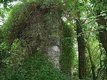
Duchal Castle, on the outskirts of Kilmacolm, was constructed by Ralph de l'Isle (later Anglicised to Lyle) in the 13th century and remained in the family until purchased by the Porterfields in 1544. The Porterfields occupied the castle until 1710 when much of it was deconstructed and the stone used to build a new home further down the River Gryffe, which exists to this day as Duchal House. The ruins of the castle are still located in the parish. The name 'duchal' means 'between two rivers' and this indeed is reflected in the Castle's position, set between Green Water and its tributary, the Blacketty Water.[12] Most significant in the Castle's history was its siege by King James IV of Scotland in July 1489, following the Lyle's support of an insurrection against him. The King attended personally and, according to accounts, the inhabitants of the Castle surrendered immediately on the sight of the famous Mons Meg cannon being rolled into position against them. The castle, however, was fired upon, and one of the Royal cannon gained the name Duchal.[13]
The Dennistoun family originated in the parish in the mid-12th century and ended with Sir Robert Dennistoun, who died in 1399 with no male heirs. His two daughters inherited his parts of his estate and married into two new noble families, thus creating three main estates in Kilmacolm rather than two. The Cunninghams, later to become the Earls of Glencairn had their seat at Finlaystone House and the Maxwells later constructed a seat at Newark Castle in an area once known Nether Finlaystone.[14] With the death of John Cunningham, 15th Earl of Glencairn in 1796 his title became extinct. Finlaystone House was passed to multiple owners, and is now the seat of the chief of the Clan MacMillan. In 1668, Sir George Maxwell sold much of his lands at Newark to the city of Glasgow, for the development of Port Glasgow. A later Sir George Maxwell disposed of his estate in the early 18th century.[15] Newark Castle is now owned and operated by Historic Scotland.[16]
The Duchal estates were acquired from the Lyles by John Porterfield in 1544. The Porterfields were staunch Covenanters and Duchal was widely seen as a refuge when the profession of such sympathies was criminalised. Conventicles were held in the estate, particularly on the natural amphitheatre which is positioned within the present-day 14th hole of the Kilmacolm Golf Club. As a result of these religious sympathies, the estate was sequestered by the Crown in 1684 and the men of the Porterfield family arrested; it was however returned following the Glorious Revolution.[17]
The last of the Duchal-based Porterfield family was James Corbett Porterfield, who died without an heir in 1855. His estate then passed to Sir Hugh Shaw-Stewart, 8th Baronet, who served as a Unionist politician. Duchal House was subsequently purchased by the first Lord Maclay, and remains in the family to this day.
Modern Kilmacolm

The arrival of the railway in Kilmacolm in 1869 marked a significant turning point in the village's history and lead to Victorian era expansion on a grand scale. Prior to this development, the village had changed little in the preceding centuries, falling behind the development of other parts of the county.[18] Kilmacolm's rail connection came about as a result of railway companies entering into the shipping trade and the perceived need to link Glasgow directly to Greenock's waterfront. Links to the wider world, and particularly Glasgow, made the village an attractive dormitory settlement.[19]
Kilmacolm expanded at an unprecedented speed and many of the large Victorian and Edwardian villas which characterise the village today were constructed, as well as such attractions as the Hydropathic Hotel[20][21] and facilities such as banks and plumbed water. Combined with the dramatic expansion of the village and gentrification of the area, the traditional importance of agriculture to the parish economy declined significantly.[22] Slightly further east on the railway line, William Quarrier's Orphans' Homes were opened in the 1870s and remained as a residential children's community until the late 1970s. Since then, what has become known as Quarrier's Village has become largely residential.[23]
Kilmacolm gradually became a place with numerous amenities, with the construction of the Victorian schoolhouses of the village, the opening of a Royal Bank of Scotland branch in 1872 and piped clean water in 1878.[24] Indicative of the changes which the gentrification of the village brought, in the 1920s a local referendum was held in the village under the Temperance (Scotland) Act 1913, resulting in it becoming a dry parish where the sale of alcohol was illegal. The numerous public houses which had existed in the Kilmacolm declined and it was to have no such establishment from this time until the 1990s.[24] In 1921, the parish council purchased the former Buchanan Arms building at the cross, turning it into a Village Institute or community centre, which it has continued to be until the renovation of the Cargill Centre in 2009-10.[25] In the religious sphere, the establishment of many of Kilmacolm's churches can be credited to religious disagreements, particularly the practice of patronage within the Church of Scotland - which allowed local landowners to choose a parish minister. This practice ended in 1874.[26]
World War I paused local development somewhat, and 300 men (66 of whom were officers) in the parish enlisted in the British Armed Forces. The village came to accommodate a number of Belgian refugees.[27] In the Second World War, Kilmacolm was used to house evacuees from Glasgow and public buildings were used to house those made homeless by the Greenock Blitz in 1941. One bomb fell in Kilmacolm, causing minor damage and, following the war, the hydropathic hotel was used as a naval hospital until being returned to private ownership with its purchase by Stakis Hotels.[28]
The modern village retains the character of its Victorian and Edwardian boom.[29] Kilmacolm railway station was closed in 1983, and the track converted into a recreational cycle path. Despite an increase in new housing in the village during the latter half of the 20th century and a corresponding increase in population, particularly in the 1960s and 70s, Kilmacolm has remained reasonably static in size over the past decade. Expansion into green belt land is now discouraged and, combined with a high demand for housing, this has led to an identified shortage of affordable housing in the village.[30]
The Olympic Flame was carried through the village on 8 June 2012 as part of the British Isles torch relay in celebration of the London 2012 Olympic Games.[31]
Governance


Kilmacolm is the name of a wider civil parish, including the village of Kilmacolm, Quarrier's Village and a large rural hinterland. Civil parishes have been largely superseded in local government by modern community council areas, with Kilmacolm, Quarrier's Village and the surrounding area falling within the Kilmacolm community council area.[32]
In common with other such bodies, Kilmacolm Community Council is not party political. It meets monthly in the Cargill Centre, except in July and December, with an annual general meeting held in May. The most recent elections to the body were held in October 2011.[33]
At a higher level, Kilmacolm elects members to the local authority - Inverclyde Council - as well as to the Scottish Parliament, the Parliament of the United Kingdom and the European Parliament.
Local government
Local government for Kilmacolm and Quarrier's Village is exercised by Inverclyde Council, one of the three local authority areas in Renfrewshire and one of thirty-two across Scotland. The parish is represented by Kilmacolm community council, a statutory body consulted in relation to local government matters.[34] Since 1999, the administration of local government in Scotland has been a devolved matter within the competence of the Scottish Parliament.
Following the introduction of proportional representation in local council elections, Kilmacolm was joined with Port Glasgow to create a four-member ward known as Inverclyde East in time for the 2007 local elections. As a result of the 2012 Inverclyde council elections, the four councillors currently representing the ward are James McColgan (Labour), Jim Macleod (Scottish National Party), Stephen McCabe (Labour, Leader of the Council), and David Wilson (Conservative, Deputy Provost).
Central government
Kilmacolm is part of the Inverclyde constituency for elections to House of Commons in the Parliament of the United Kingdom.[35] The constituency was created in 2005, with Kilmacolm previously falling within the West Renfrewshire constituency. Following the 2015 UK general election the current Member of Parliament for the area is Ronnie Cowan MP
For elections to the Scottish Parliament, Kilmacolm is currently part of the Renfrewshire North and West constituency, changing in 2011 from the previous Renfrewshire West constituency. It is also part of the West of Scotland Scottish Parliament electoral region.[35] The incumbent constituency Member of the Scottish Parliament is Derek Mackay MSP.
Politics
By the early 2000s, before the introduction of proportional representation for local council elections in Scotland in 2007, Kilmacolm was considered a safe Conservative ward and typically elected the only Conservative member to Inverclyde Council.[36]
Following the death of Councillor Alex Calvert, a by-election was held in the Kilmacolm ward on 8 February 2001. Turnout fell to 43.9%, down from 65.3% in the 1999 election, and turned Kilmacolm into a Conservative-Liberal Democrat marginal area, with the Conservatives' (represented by the former councillor's wife, Helen Calvert) lead being slashed 29% to 6% over the Lib Dems who rose from fourth to second place in the poll. In 2003, Liberal Democrat Tom Fyfe was elected by a narrow margin in Kilmacolm, also marking the return of control of Inverclyde Council from Labour to the Lib Dems.[37]
Geography
 |
Port Glasgow | Newark | Langbank | |
| Clyde Muirshiel Regional Park | |
Houston | ||
| ||||
| | ||||
| Largs | Lochwinnoch | Bridge of Weir |

At 55°53′27″N 4°36′58″W / 55.89079°N 4.61601°W Kilmacolm is situated in the Gryffe Valley in Scotland's western Central Lowlands. The village lies 350 feet (110 m) above sea level, 4 miles (6 km) south-east of Port Glasgow, 7 1⁄2 miles (12 km) east-south-east of Greenock, the administrative centre of Inverclyde; and 15 miles (24 km) west-north-west of Glasgow, the nearest city.[1]
Kilmacolm lies within a civil parish of the same name of 29.6 square miles (77 km2) of largely rural land.[38][39] The parish stretches to the Firth of Clyde, some 4 miles (6 km) north of the village, and west into the Clyde Muirshiel Regional Park.[38][39] The parish borders the parishes of Erskine, Greenock, Houston and Killellan, Inverkip, Kilbarchan, Largs, Lochwinnoch and Port Glasgow.[38]
The area generally consists of lightly sloping and occasionally rocky (mostly granite) moorland.[39] Despite this, the parish is home to the highest point in Inverclyde, Creuch Hill at a height of 441 m (1446 ft).[40] The River Gryffe, a tributary of the Black Cart Water, begins its flow in the village, running through Quarrier's Village and then on to Bridge of Weir and other villages in the Gryffe Valley.[39][41]
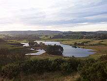
A number of significant bodies of water exist close to the village, including the Auchendores reservoir at Cloak (to the north of the village) and the Knapps Loch, part of the Duchal estate.[42][43] The Knapps Loch and the area around it is used for recreational activities and events in the village. The Loch is itself artificial, having been created by a local angling club in the early 20th century. It is shallow, with a number of islands, and has a small boathouse and landing stage at the shore.[44]
Demography
| Kilmacolm | Inverclyde | Scotland | |
|---|---|---|---|
| Total population | 4,000 | 84,203 | 5,062,011 |
| Foreign born | 3.8% | 2.1% | 3.8% |
| Over 75 years old | 8.7% | 7.3% | 7.1% |
| Unemployed | 2.4% | 4.6% | 3.9% |
In the 2001 United Kingdom Census, Kilmacolm is listed as a locality area consisting of the main village settlement.[46]
The total population of the village and census area was 4,000. 95.9% of this population were born in the United Kingdom, with 81.0% born in Scotland or a part of the UK not specified. 0.4% were born in the Republic of Ireland, with 1.1% born in the rest of Europe and 2.4% born elsewhere.[45]
The median age of males and females living in Kilmacolm was 43 and 46 years respectively, compared to 37 and 39 years for those in the whole of Scotland. Kilmacolm has a higher than average level of older people, with categories of people under the age of 45 being below the Scottish average, and categories above that age being higher; 23% of people in Kilmacolm are of pensionable age and over contrasting with 19% in Scotland as a whole.[47]
Economy
Prior to the Victorian era gentrification of the village, Kilmacolm had an almost entirely agricultural economy. Its income was boosted in the late 18th century by being a site of fairs, markets and religious events. In the 18th and 19th centuries, weaving took place in the village producing cotton and linen. This production initially existed as a cottage industry and later a small factory was opened in the 1870s.[48] The 19th century saw a downturn in the village, which was slow to adopt modern farming practices and overtaken in importance by other nearby settlements.[49]
The village's Victorian and Edwardian expansion was largely a response to the greater commuting opportunities available following the arrival of the railway in the village in 1869. The laying of a railway line through Kilmacolm occurred in order to provide a direct boat train link between Glasgow's St Enoch station and the harbour at Princes Pier in Greenock. The clean air of the parish was hailed as having great health benefits, attracting both visitors and new residents who constructed significant residential properties in the village.[50]
Since this time, the village has been primarily a residential dormitory settlement, with the economy accordingly altering its focus to the provision of services to residents and visitors.[51] Kilmacolm developed as a holiday resort in the late 19th and early 20th centuries, mainly surrounding the hydropathic hotel opened in 1880.[52]
Culture and community

Parks and recreation
There are number of community and recreational facilities in Kilmacolm. Set largely in open countryside, a number of outdoor pursuits such as angling and golf are available in the local area. Clyde Muirshiel Regional Park extends into the parish, which also contains Glen Moss Wildlife Reserve, a Site of Special Scientific Interest operated by the Scottish Wildlife Trust.[53]
A public park, Birkmyre Park, was donated by local merchant Adam Birkmyre for the benefit of the parish in 1897. The park is held and managed by the Birkmyre Trust.[54] Recent redevelopment has modified the park's pavilion to contain a fitness gymnasium, a café and changing facilities as well as including a new children's playpark.[55] Birkmyre Park also hosts association football, rugby and cricket within its grounds.[56] In 2009, the Trust proposed reopening the former tennis courts and putting green in Birkmyre Park following public consultation, as well as creating a court for basketball and netball.[57] Two smaller public parks exist within the Kilmacolm area: the smaller West Glen Park and a playpark in Quarrier's Village.[58]
Sport
Local sports teams generally meet at the village's Birkmyre Park. These include the Birkmyre Rugby Club, who compete in the Scottish Rugby Union's West regional league and Kilmacolm Cricket Club, an amateur team with a long history.[59][60] The park is also used by sports teams for the village's schools.
There is also a Kilmacolm Golf Club, Kilmacolm Tennis Club, Kilmacolm Bowling Club and Kilmacolm Squash Club, all of which have their own private facilities.[61][62][63][64]
Events
There was formerly a funfair held annually in Birkmyre Park. Due to park refurbishment, it has not continued in recent years although alternative sites are under review.[58] A circus visited the park in 2010.[65]
The field beside the Knapps Loch is used for community events such as the Kilmacolm and Port Glasgow Agricultural Society's annual show and the Bonfire Night celebrations organised by the Kilmacolm & Quarriers Village Conservative and Unionist Party.[43]
Cultural references
Kilmacolm is depicted as 'Kilellan' in R.J. Price's Renfrewshire short stories A Boy in Summer (2002) and features briefly in Raymond Friel's poetry collection Stations of the Heart (2009). The Scottish sketch comedy Chewin' the Fat also featured a character, a man who breaks cultural taboos or does something very anti-social. When challenged or criticized, he then explains away his actions by saying that he's "fae Kilmacolm", which would immediately win understanding of his superiority from everyone around him.
Notable people
People with links to Kilmacolm are known as Kilmacolmics or Kilmacomics.[66][67]
The village has a long political tradition. The first Lord Maclay was a shipbuilder and later served as a minister from 1916-1922 in the coalition government. His son, the second Lord Maclay served as a Liberal MP for Paisley. John Maclay, 1st Viscount Muirshiel, the younger brother of the second Lord Maclay, was a National Liberal and Conservative MP, who served as Secretary of State for Scotland from 1957 to 1962. Annabel Goldie, The Baroness Goldie, former leader of the Scottish Conservatives (2005–11) and member of the House of Lords was brought up in Kilmacolm and serves as a deputy lieutenant for Renfrewshire.[68] Eleanor Laing, the Conservative Member of Parliament for Epping Forest and Deputy Speaker of the House of Commons, was raised and educated in the village.[69]
In entertainment and the arts, musicians Jim Kerr of Simple Minds and Chrissie Hynde of The Pretenders were residents of Kilmacolm,[70] as was Gerry Rafferty in the 1970s. Hedrick Smith, a broadcaster in the United States, and television presenter Dallas Campbell also originate here. In business and industry Sir Eric Yarrow Bart., DL, notable for his connection with Yarrow Shipbuilders, is a current resident, and Ronald Campbell OBE - an engineer and pioneer of nuclear power in the UK - was brought up in the area. [71][70] The late Wing Commander Hector McLean of the Royal Air Force was a lifelong resident of the village.[72]
In sports, Rachael Ferrier, who competed in the 2014 Winter Paralympics at Sochi as a sighted guide for visually impaired athlete Millie Knight also resides in Kilmacolm.
Prof William Arthur Harland FRSE, Professor of Forensic Medicine at Glasgow University lived in Kilmacolm.[73]
Twinning
In May 2014, Kilmacolm signed a twinning agreement with the village of Mérignies in the Nord department of north-east France. The arrangement was formalised with delegations from both villages at Kilmacolm's annual village show, and in Mérignies a month later.[74]
Landmarks

Whilst the village has a long history, the majority of its significant architecture is Victorian and Edwardian in origin, beginning with the arrival of the railway in the village, its gentrification and the subsequent boom in population. Utilising a wide variation of styles, the parish contains a considerable number of listed and notable buildings.[75]
William Leiper's flamboyant Gothic Revival St Columba's Church (c.1902) is the most apparent Category A listed building in the village. The parish church (Old Kirk), mainly constructed in 1831 incorporating a 13th-century chancel, is B-listed and another example of the Gothic Revival style. The third listed church in the parish, Mount Zion Church (Quarrier's Village; 1888; Robert A Bryden) is also Category B listed and in the Scots Baronial style.[75]
Kilmacolm's community centre, reopened in 2011 as the Cargill Centre following a refurbishment and donation from the WA Cargill Trust, has a significant position in the centre of the village and consists of two Victorian former schoolhouses. It contains a village hall, police office and is planned to house the village's relocated public library later in 2011.[75][76][77] Other notable non-residential listed buildings in the parish include Bridge of Weir Hospital built by William Quarrier, as a sanatorium for tuberculosis sufferers at the turn of the 20th century, in the free revivalist style and incorporating ecclesiastical references. The Hospital buildings are Category B listed, and have been converted into private flats. Shallot, the former mansionhouse of Adam Birkmyre which now accommodates the St Columba's Junior School, constructed in 1884, is also B-listed.
In the countryside outside the village are the ruins of Duchal Castle, dating back to the 13th century and lending its name to the modern Duchal House and estate in the village.[78] On a hill above the village lies the derelict remains of Balrossie School, formerly the Sailors' Orphans' Home.[79] Of historical interest are preserved examples of significant anti-aircraft batteries dating back to the Second World War contained within the parish, and a Decontamination Centre built in case of gas attacks on the United Kingdom.[80][81] There is also a narrow-gauge railway line formerly used for grouse-shooting in Kilmacolm. Known as the Duchal Moor Railway, it lies within the Clyde Muirshiel Park; it was used by, amongst others, King Edward VIII and finally closed in the 1970s.[82]
Residential buildings


A number of large private homes are also notable in the parish, which are also drawn from a wide variety of architectural styles. The village hosts a number of examples of the arts and crafts style, most notably 'Windyhill' (c.1900), designed by Charles Rennie Macintosh. This is one of a number of buildings Macintosh was involved with in the village and alongside the Hill House is one of only two residential buildings wholly designed by him.[83][84]
In the adjacent plot to Windyhill is James Salmon's 'Rowantreehill' of the same era, an unusual building which was designed by Salmon as a family home for his own use.[85] James Salmon and Charles Rennie Mackintosh were friends and sharing influences a following of the Glasgow Style artistic movement.[86] Both Salmon and Mackintosh went on to contribute more of their work to Kilmacolm, Salmon designing four more listed homes. Following William Leiper, the architect of St Columba's Church, being commissioned to design Auchenbothie House, Mackintosh was again recruited to design the building's gatehouse and to contribute to the expansion of nearby Cloak, all of which fell within the estate of Major Hugh Brown Collins, a mining engineer.[42][75] Although Mackintosh planned for a tower to the constructed at Cloak, this was never executed.[87] Auchenbothie House was donated by former owner Sir James Lithgow to the town council of nearby Port Glasgow in 1949 to be used as a home for the elderly; it later lay vacant before being converted into residential flats.[88]
Other notable architects to have practiced in Kilmacolm include Sir John James Burnet whose works in the village include the Kidston Hall and the major late 19th-century renovation of Finlaystone House and James Austen Laird, who worked on numerous homes in the village.[75][89] Also of significance are the former orphans' homes at Quarrier's Village, many of which are listed. The homes were designed individually according to the wishes of donors, mainly by Glasgow architect Robert A. Bryden. As previously mentioned, Bryden was also responsible for a number of the non-residential buildings in Quarrier's Village including Mount Zion Church, Elise Hospital and what became Bridge of Weir Hospital, the latter two having been converted into a home for the elderly and a residential development respectively.[75]
Historic houses
Finlaystone House, a mansion house in the Baronial Revival style and former seat of the Earls of Glencairn, is Category A listed. The current building is mainly that constructed in 1760 around an earlier nucleus, and extensively added to and altered in the late 19th century.[75] It is now seat of the Chief of the Clan MacMillan, with both building and grounds used for public events and visits.[90]

Duchal House, which was constructed from stone from the aforementioned (now ruined) Duchal Castle, is a Renaissance style country house originally built in 1710 and largely rebuilt c. 1768 incorporating some of the previous structure. It is now the seat of current Lord Maclay.[75]
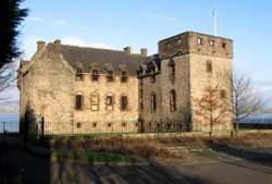
The third historic seat of Kilmacolm, Newark Castle, is no longer within the parish, having been incorporated into Port Glasgow. It is currently in the possession of Historic Scotland.
Monuments
Kilmacolm has a large Celtic cross-style war memorial sited on a hill to the south-east of the village. The land that it is built upon was donated for the purpose by the first Lord Maclay, who purchased Duchal House and its estates in 1915 and lost two sons in World War I.[91] In addition to his work on buildings in the village, there is also a gravestone in the parish churchyard designed by Charles Rennie Mackintosh dated 1892 and erected to the memory of one James Reid.[92]
A monument containing a time capsule is also present in the village centre, outside the old schoolhouse. It was created in 1985 to celebrate International Youth Year.[93] A lion statue lies in Birkmyre Park.[94]
Transport
Kilmacolm is well connected by road, lying on the A761 between Greenock and Paisley a short distance from the link to the M8 motorway to Glasgow at Johnstone, and is thus popular with commuters.[95][96] The Strathclyde Partnership for Transport, a public body, has direct operational responsibilities covering the area, such as supporting (and in some cases running) local bus services in Kilmacolm and across Strathclyde.[97] Kilmacolm is served by the nearby Glasgow International Airport.[70]
The former railway station, now a public house, operated in the village between 1869 and the 1980s. The railway played a significant role in the village's modern history and expansion, linking it conveniently to nearby urban centres such as Glasgow, Greenock and Paisley. Today, Kilmacolm's nearest National Rail link is at Port Glasgow railway station which lies on the Inverclyde Line linking Glasgow with Gourock and Wemyss Bay. The Ayrshire Coast Line, running between Glasgow and the south-west coast of Scotland, is accessible at nearby Lochwinnoch railway station.
The former railway track serving Kilmacolm has been converted into a cycle path, and is now part of the Clyde to Forth cycle route (National Cycle Route 75). The route of the line has been preserved, and has been confirmed by Strathclyde Partnership for Transport to be available for use again should future redevelopment of the line be considered.[98]
Education
There are currently two schools in Kilmacolm: Kilmacolm Primary School, a state school, and St Columba's School, an independent school offering both primary and secondary education. The nearest state secondary school in Inverclyde which serves the village is Port Glasgow High School.[70]
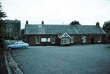
The first schoolhouse was opened in the village in 1858. With the increase in population and the compulsory education introduced by the parish school board in 1889 under the Education (Scotland) Act 1872 the small building could no longer cope with demand and in 1888 a larger building was constructed adjacent to the old with accommodation for 600 pupils. In 1971, the school moved to a new site on Churchill Road, Pacemuir estate, and continues to exist as Kilmacolm Primary School, whilst the old schoolhouse is used as a community centre.[99]
1897 saw the creation of St Columba's School, an independent day school for girls, in the village. Since 1982, the school is fully coeducational, and the serves 730 pupils between its junior and senior schools.[100][101]
Religion

The Christian religion has had a significant impact in Kilmacolm's history. It was the site where John Knox performed what was possibly the first Protestant communion in Scotland, a centre for Covenanters and a home for numerous historic religious festivals - often accompanied by drinking and 'riotous behaviour'.[102] There are currently two congregations of the established presbyterian Church of Scotland, one Episcopal church which is part of the Anglican Communion and one Roman Catholic Church in the village. A further Church of Scotland congregation meets in Quarrier's Village.
The Parish Church, known as the "Old Kirk", is ancient in origin. Its chancel dates back to the 13th century and is incorporated into the modern structure, built in 1830 as a replacement for a structurally unsound 16th century main building, as the Murray Chapel.[103]
In 1858, a number of the Parish's inhabitants broke away to form a United Presbyterian church in what had until recently been the abandoned Reformed Presbyterian Church. In 1868 the Church of St James was constructed on the site which now houses the Royal Bank of Scotland branch and lends its name to the town's main shopping terrace. There are no remains of this church today.
The congregation of St James's Church planned a new building in 1900, which was completed in 1903. This new Church of St James united with St Columba's Church, which was formed in the 1870s following another schism within the Church of Scotland. This former St Columba's Church stood on Bridge of Weir Road, and is recorded as standing in 1907 although the date of its construction is unknown. The magnificent spire and much of the church was demolished in the 1960s, but the main hall still remains and serves as the Kilmacolm Masonic Temple facing onto Glebe Road. The slates from the roof of the old church were used on the roof of "The Glen" being built at that time in Glencairn Road. When the church was demolished and the congregations of St Columba's and St James's united, the former St James's Church where they met was renamed St Columba's Church - recognising the origins of the village name and its relationship with Columba. Through various unions, this church has become part of the Church of Scotland, alongside the "Old Kirk" Parish Church. These Church of Scotland churches form part of the Presbytery of Greenock and Paisley in the Synod of Clydesdale (see: Church of Scotland synods and presbyteries).[104]
Kilmacolm forms part of the Episcopalian (Anglican) Diocese of Glasgow and Galloway and is served by St Fillan's Church on Moss Road.[105] Similarly to the ancient ruined church located nearby at Killellan, the St Fillan that the church is dedicated to is most likely Faelan of Cluain Moescna. The village also falls within the Roman Catholic Diocese of Paisley and Deanery of Inverclyde. There is one small Roman Catholic church in the village, St Colm's.[106] Dedicated to St Columba, for whom St Colm is an alternative name, the current church building was constructed in 1995.
Public Services
The territorial police force covering Kilmacolm is the Police Service of Scotland, with Kilmacolm falling within its Renfrewshire and Inverclyde division, which is further subdivided into three area commands - in this case, Inverclyde. There is a small police office in the village - relocated in early 2011 from a separate police building to within the Cargill Centre.[64][65] For judicial purposes, the area forms part of the sheriffdom of North Strathclyde and public prosecutions are directed by the Procurator Fiscal for Argyll and Clyde.
NHS Greater Glasgow and Clyde is the National Health Service Board providing public health care in Kilmacolm. The village also falls within the Inverclyde Community Health Partnership area - an organisation which plans and delivers a number of NHS services. Within the village itself, there are two general practitioner's surgeries.[107] The nearest major hospitals with accident and emergency facilities are the Inverclyde Royal Hospital in Greenock and Royal Alexandra Hospital in Paisley. The Scottish Fire and Rescue Service is the statutory fire and rescue service covering the Kilmacolm area, the nearest station being at Port Glasgow.[108]
Water and sewerage is provided in Kilmacolm by Scottish Water, a public body, and water and sewerage charges are collected alongside council tax by Inverclyde Council, the local authority, on its behalf.[109] Inverclyde Council is also responsible for the provision of waste management in the area.[110] Kilmacolm's Distribution Network Operator, the organisation licensed to transmit electricity from the National Grid to consumers, is Scottish Power.[111]
References
Footnotes
- 1 2 3 The Editors of the Gazetteer for Scotland. "Kilmacolm history, Gazetteer for Scotland". University of Edinburgh. Retrieved 13 June 2009.
- ↑ Roe 2007, p.20
- ↑ Kilmacolm Old Kirk. "About Us". Church of Scotland. Archived from the original on 8 September 2008. Retrieved 13 June 2009.
- ↑ "Meeting commemorated in stained glass window, Old Kirk". The Advertizer Newspaper. Retrieved 13 June 2009.
- ↑ Roe 2007, pp. 20-21
- ↑ Roe 2007, pp. 2-4
- ↑ Roe 2007, pp. 4-14
- ↑ Roe 2007, pp. 14-18
- ↑ Site Record for Milton Bridge Duchal HouseDetails Details
- ↑ Roe 2007, pp. 30-31
- ↑ Roe 2007, pp. 32-33
- ↑ Roe 2007, pp. 40-44
- ↑ Roe 2007, pp. 49-53
- ↑ Roe 2007, p. 30
- ↑ Roe 2007, p. 165
- ↑ "Property Detail: Newark Castle". Historic Scotland. Retrieved 3 January 2011.
- ↑ Kilmacolm history
- ↑ Roe 2007, p. 111
- ↑ Roe 2007, p. 113
- ↑ Bradley, James; Dupree, Mageurite; Durie, Alastair (1997). "Taking the Water Cure: The Hydropathic Movement in Scotland, 1840-1940" (PDF). Business and Economic History. 26 (2): 429. Retrieved 17 November 2009.
- ↑ Shifrin, Malcolm (3 October 2008). "Victorian Turkish Baths Directory". Victorian Turkish Baths: Their origin, development, and gradual decline. Retrieved 12 December 2009.
- ↑ Roe 2007, pp. 116-118.
- ↑ "Quarrier's History". Quarrier's charity. Retrieved 13 June 2009.
- 1 2 Roe 2007, p. 118
- ↑ Roe 2007, p. 149
- ↑ Roe 2007, p. 133
- ↑ Roe 2007, p. 145
- ↑ Roe 2007, pp. 156-157
- ↑ Roe 2007, p. 159
- ↑ Reporter to the Scottish Ministers. "Affordable Housing (Kilmacolm)" (PDF). Retrieved 13 January 2010.
- ↑ OLYMPIC Flame Will Be Carried Through Kilmacolm And Port Glasgow
- ↑ Inverclyde Council maintains a map of its community council areas available on the Councils section of their website, retrieved 26 July 2015
- ↑ Kilmacolm Community Council website 'About' section and governance documents, Retrieved 26 July 2015
- ↑ http://www.kilmacolmcc.co.uk/
- 1 2 "Boundary maps for constituencies in Scotland". Boundary Commission for Scotland. Retrieved 13 June 2009.
- ↑ Kilmacolm (Inverclyde) 8 February 2001
- ↑ Inverclyde Council, Published local election results, 1999-2003
- 1 2 3 The Editors of the Gazetteer for Scotland. "Parish of Kilmacolm, Gazetteer for Scotland". University of Edinburgh. Retrieved 13 August 2009.
- 1 2 3 4 Rev. R. Cameron, Statistical Account of the Parish of Kilmacolm 1836
- ↑ The Editors of the Gazetteer for Scotland. "Creuch Hill, Gazetteer for Scotland". University of Edinburgh. Retrieved 2010-07-04.
- ↑ The Editors of the Gazetteer for Scotland. "River Gryfe, Gazetteer for Scotland". University of Edinburgh. Retrieved 13 August 2009.
- 1 2 "Scotland: Cloak wrapped in mystery". London: The Sunday Times. 23 March 2003. Retrieved 13 August 2009.
- 1 2 "November 2008 Meeting Minutes" (PDF). Kilmacolm Community Council. November 2008. Retrieved 13 June 2009.
- ↑ The Editors of the Gazetteer for Scotland. "Knapps Loch, Gazetteer for Scotland". University of Edinburgh. Retrieved 13 April 2010.
- 1 2 "2001 Census, Comparative Population Profile - Kilmacolm and Inverclyde". General Register Office for Scotland. Retrieved 13 June 2009.
- ↑ "Scottish 2001 Localities". General Register Office for Scotland. Retrieved 13 June 2009.
- ↑ "2001 Census, Comparative Population Profile of Kilmacolm and Scotland". Retrieved 13 June 2009.
- ↑ Roe 2009, pp. 98-99
- ↑ Roe 2007, pp. 91-92
- ↑ Roe 2007, pp. 112 - 114
- ↑ Roe 2007, pp. 113-115
- ↑ Roe 2007, p. 121
- ↑ "Glen Moss Wildlife Reserve". Scottish Wildlife Trust. Archived from the original on 27 September 2007. Retrieved 13 June 2009.
- ↑ The Lord Justice Clerk (24 August 2005). "Inverclyde Council v. Dunlop". The Court of Session. Retrieved 13 June 2009.
- ↑ "Birkmyre Park webpage". Inverclyde Leisure. Retrieved 13 June 2009.
- ↑ "February 2009 Meeting Minutes" (PDF). Kilmacolm Community Council. Retrieved 13 June 2009.
- ↑ "November 2009 Meeting Minutes" (PDF). Kilmacolm Community Council. Retrieved 12 January 2010.
- 1 2 "April 2009 Meeting Minutes" (PDF). Kilmacolm Community Council. Retrieved 13 June 2009.
- ↑ "Birkmyre Rugby Club website". Birkmyre Rugby Club. Retrieved 19 January 2010.
- ↑ "Kilmacolm Cricket Club website". Kilmacolm Cricket Club. Retrieved 10 January 2010.
- ↑ "Kilmacolm Golf Club website". Kilmacolm Golf Club. Retrieved 13 June 2009.
- ↑ "Grants Sub-Committee - 17 February 2005". Inverclyde Council. 17 February 2005. Retrieved 10 January 2011.
- ↑ "Kilmacolm Tennis Club website". Kilmacolm Tennis Club. Retrieved 10 January 2011.
- 1 2 "Our Community". David Cairns MP. Retrieved 5 December 2009.
- 1 2 "Chairman's Report, 2010 AGM" (PDF). Kilmacolm Community Council. Retrieved 20 October 2010.
- ↑ "The Columban" (PDF). St Columba's School, Kilmacolm. 20 December 2007. Retrieved 2 November 2010.
- ↑ Ken Smith (26 June 2006). "The Diary". The Glasgow Herald. Retrieved 2 November 2010.
- ↑ http://www.bcomm-scotland.gov.uk/includes/downloadfile.asp?file=/5th_westminster/localinquiries/renfrewshire/Transcript%20of%20Proceedings.pdf
- ↑ Manufacturing Employment (Hansard, 30 January 2001)
- 1 2 3 4 Christine Ferguson (21 September 2003). "Scotland's Best Towns: Join the Kilmacolm set". London: The Sunday Times (Life and Style). Retrieved 13 June 2009.
- ↑ http://www.heraldscotland.com/opinion/obituaries/13207386.Ronald_Campbell/
- ↑ "Wing Commander Hector MacLean". The Daily Telegraph. London. 28 August 2007.
- ↑ http://www.harlanddiaspora.net/page50.html
- ↑ http://www.greenocktelegraph.co.uk/news/villages/articles/2014/05/17/498584-french-delegation-sign-twinning-agreement-at-kilmacolm-show/
- 1 2 3 4 5 6 7 8 "Kilmacolm and Quarrier's Village Index (listed buildings)". Inverclyde Council. Retrieved 13 June 2009.
- ↑ "Kilmacolm New Community Centre - Business Plan". Kilmacolm New Community Centre Company Ltd. Retrieved 13 August 2009.
- ↑ "Regeneration Committee: Kilmacolm New Village Centre Report". Inverclyde Council. 3 September 2009. Retrieved 13 December 2009.
- ↑ "Site Record: Duchal Castle". Royal Commission on the Ancient and Historical Monuments of Scotland. Retrieved 13 August 2009.
- ↑ "Site Record: Balrossie School". Royal Commission on the Ancient and Historical Monuments of Scotland. Retrieved 13 August 2009.
- ↑ "Site Record: High Mathernock Battery". Royal Commission on the Ancient and Historical Monuments of Scotland. Retrieved 13 August 2009.
- ↑ "Site Record: Lochwinnoch Road Decontamination Centre". Royal Commission on the Ancient and Historical Monuments of Scotland. Retrieved 13 August 2009.
- ↑ the Gazetteer for Scotland. "Overview of Grouse Railway". University of Edinburgh. Retrieved 13 December 2009.
- ↑ Anna Tyzack (5 April 2009). "Classical property still has some clout". London: The Daily Telegraph. Retrieved 13 August 2009.
- ↑ "On the Market: Windyhill by Charles Rennie Mackintosh". Robb Report Collection. 7 January 2007. Retrieved 13 October 2010.
- ↑ "Rowantreehill house listing". Rightmove. Retrieved 12 October 2010.
- ↑ Raymond O'Donnell. "The Wee Troot: Letters to New Zealand - James Salmon, architect". Edinburgh University Press. Retrieved 19 October 2010.
- ↑ "Mosside (later Cloak), Kilmacolm: south elevation c.1906". Hunterian Museum, Glasgow. Retrieved 19 December 2010.
- ↑ 'Sir James Lithgow gives Auchenbothie House to Port Glasgow Town Council to use as an old peoples' home', Greenock Telegraph, 1949-02-09
- ↑ "DSA Entry: James Austen Laird". Dictionary of Scottish Architects. 2008. Retrieved 19 October 2010.
- ↑ "Finlaystone Country Estate - History". Finlaystone Estate. Retrieved 13 August 2009.
- ↑ D. Roe, op cit, p. 147
- ↑ "Site Record: Kilmacolm Cemetery, Gravestone of James Reid". Royal Commission on the Ancient and Historical Monuments of Scotland. Retrieved 13 April 2010.
- ↑ "Site Record: Campbell Place Time Capsule". Royal Commission on the Ancient and Historical Monuments of Scotland. Retrieved 13 August 2009.
- ↑ "Library Photographic Archive: Kilmacolm, Birkmyre Park (JV-D1877)". University of St Andrews. 4 October 1956. Retrieved 13 August 2009.
- ↑ "Bridge Of Weir Road, Kilmacolm, Renfrewshire". Slater Hogg and Howison Estate Agents. Retrieved 7 December 2009.
- ↑ "Kilmacolm:about the area". Kilmacolm Advertizer. Retrieved 7 December 2009.
- ↑ Strathclyde Partnership for Transport (5 September 2007). "Who we are". spt.co.uk. Archived from the original on 12 December 2007. Retrieved 11 February 2008.
- ↑ "Transport authority gives some hope over station". The Herald (Glasgow). Retrieved 11 February 2010.
- ↑ Roe 2007, p.99-100
- ↑ http://www.scis.org.uk/schools/details/52/St-Columbas-School
- ↑ History
- ↑ Books: Kilmacolm
- ↑ Visitscotland Kilmacolm Old Kirk Kilmalcolm Place of Worship Welcome
- ↑ Presbytery and Synod since amalgamated with others; See: fn.3
- ↑ "Website". St Fillan's Church, Kilmacolm. Retrieved 2 November 2010.
- ↑ "Parishes". Roman Catholic Diocese of Paisley. Retrieved 2 November 2010.
- ↑ "GP Practice List". NHS Argyle and Clyde. Archived from the original on 14 October 2007. Retrieved 5 December 2009.
- ↑ "Renfrewshire and Inverclyde area plan" (PDF). Strathclyde Fire and Rescue. Retrieved 5 December 2009.
- ↑ "Your Council Tax Explained: 2010/11". Inverclyde Council. Retrieved 5 January 2011.
- ↑ s.30, Environmental Protection Act 1990 as amended
- ↑ "Electricity Distribution Network Operators". energylinx.co.uk. 2007. Retrieved 5 February 2008.
References
- Roe, David (2007). Kilmacolm:A History. Birlinn. ISBN 1841586218.
- Appendix 3 contains a copy of the Rev. R. Cameron's Statistical Account of the Parish of Kilmacolm of 1836.
- RCHAMS Entry on Duchal Castle
External links
| Wikimedia Commons has media related to Kilmacolm. |