Kugluktuk
| Kugluktuk Qurluqtuq ᖁᕐᓗᖅᑐᖅ | |
|---|---|
| Hamlet | |
|
Hill top view of Kugluktuk | |
 Kugluktuk | |
| Coordinates: 67°49′32″N 115°05′42″W / 67.82556°N 115.09500°WCoordinates: 67°49′32″N 115°05′42″W / 67.82556°N 115.09500°W | |
| Country | Canada |
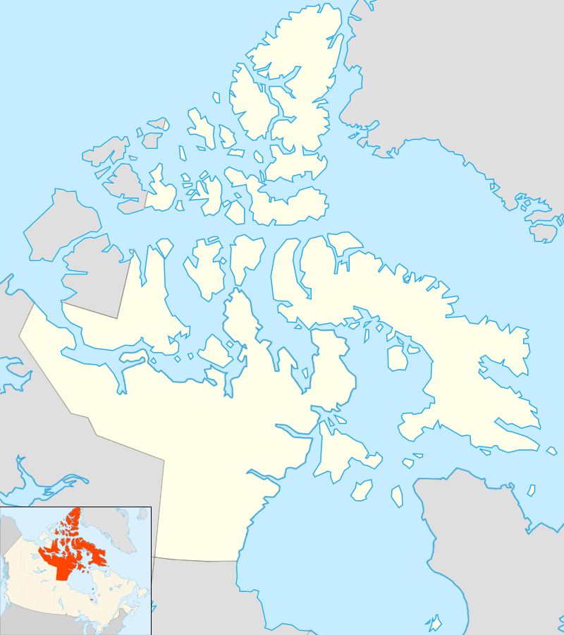
| Territory | Nunavut |
| Region | Kitikmeot Region |
| Electoral district | Kugluktuk |
| Government[1][2] | |
| • Mayor | Ryan Nivingalok |
| • MLA | Peter Taptuna |
| Area[3] | |
| • Land | 549.65 km2 (212.22 sq mi) |
| • Population centre[4] | 0.34 km2 (0.13 sq mi) |
| Elevation[5] | 23 m (75 ft) |
| Population (2011)[3] | |
| • Total | 1,450 |
| • Density | 2.6/km2 (7/sq mi) |
| • Population centre[4] | 1,082 |
| • Population centre density | 3,196.5/km2 (8,279/sq mi) |
| Time zone | MST (UTC-7) |
| • Summer (DST) | MDT (UTC-6) |
| Canadian Postal code | X0B 0E0 |
| Area code(s) | 867 |

Kugluktuk (Inuinnaqtun: Qurluktuk, "the place of moving water"; Inuktitut: ᖁᕐᓗᖅᑐᖅ, formerly Coppermine until 1 January 1996) is a hamlet located at the mouth of the Coppermine River in the Kitikmeot Region of Nunavut, Canada, on Coronation Gulf, southwest of Victoria Island. It is the westernmost community in Nunavut, near the border with the Northwest Territories.
The traditional language of the area is Inuinnaqtun and is written using the Latin alphabet, rather than the syllabics of the Inuktitut writing system. Like Cambridge Bay, Bathurst Inlet, and Umingmaktok, syllabics are rarely seen and are used mainly by the Government of Nunavut.
Location
The community has the usual services: a post office, Northern Store, co-op store, and Hunters & Trappers Association. The two schools in the area are Kugluktuk High School and Jimmy Hikok Ilihakvik. In June 2004, a fuel line broke in the center of Kugluktuk, spilling 2,000 L (439.9 imp gal; 528.3 US gal) of diesel fuel.
Demographics
At the 2011 census, the population was 1,450, an increase of 11.4% from the 2006 census.[3]
In 1982, a division plebiscite was held. While approximately 80% of the population in what is now Nunavut voted in favour of division, Coppermine was one of only two communities to vote against division. Cambridge Bay was the other.[6]
Geography
Kugluktuk is located on the shore of the Arctic Ocean. The surrounding landscape is dominated by the rocky and often barren Canadian Shield. The region has a subarctic climate, but barely so, with July having an average of 10.7 °C (51.3 °F). It has very cold winters, light snowfall, and summers too cool to permit the growth of trees. Though trees do exist in the region, they are dwarfed and extremely sparse.
Flora and fauna
Plant growth in the region during summer months includes small shrubs, grass, moss, lichens, blueberries, blackberries, cranberries, various flowers, and dwarfed willow and birch trees.
Climate
Kugluktuk's climate, when classified according to the Köppen Climate Classification, belongs to the Dfc variant of a subarctic climate.).[7] It is in the transitional zone to a Arctic Tundra (ET) Climate, but falls outside of it, since its warmest month of July surpasses the 50 °F (10 °C) isoterm, averaging 10.9 °C. Tundra climates are characterized by sub-freezing mean annual temperatures, large annual temperature ranges, and moderately low precipitation.
The highest temperature ever recorded in Kugluktuk was 34.9 °C (94.8 °F) on 15 July 1989.[8] The coldest temperature ever recorded was −50.0 °C (−58 °F) on 2 February 1968.[9]
| Climate data for Kugluktuk Airport, 1981–2010 normals, extremes 1930–present[lower-alpha 1] | |||||||||||||
|---|---|---|---|---|---|---|---|---|---|---|---|---|---|
| Month | Jan | Feb | Mar | Apr | May | Jun | Jul | Aug | Sep | Oct | Nov | Dec | Year |
| Record high °C (°F) | 0.8 (33.4) |
1.1 (34) |
0.0 (32) |
9.8 (49.6) |
23.3 (73.9) |
32.5 (90.5) |
34.9 (94.8) |
30.3 (86.5) |
26.1 (79) |
13.9 (57) |
4.4 (39.9) |
−0.5 (31.1) |
34.9 (94.8) |
| Average high °C (°F) | −23.2 (−9.8) |
−23.4 (−10.1) |
−20.7 (−5.3) |
−11.4 (11.5) |
−1.3 (29.7) |
9.9 (49.8) |
15.6 (60.1) |
13.1 (55.6) |
6.5 (43.7) |
−3.5 (25.7) |
−14.8 (5.4) |
−20.3 (−4.5) |
−6.1 (21) |
| Daily mean °C (°F) | −27.3 (−17.1) |
−27.7 (−17.9) |
−25.3 (−13.5) |
−16.3 (2.7) |
−5.3 (22.5) |
5.5 (41.9) |
10.9 (51.6) |
9.0 (48.2) |
3.3 (37.9) |
−6.6 (20.1) |
−18.7 (−1.7) |
−24.5 (−12.1) |
−10.3 (13.5) |
| Average low °C (°F) | −31.4 (−24.5) |
−32.0 (−25.6) |
−29.8 (−21.6) |
−21.2 (−6.2) |
−9.2 (15.4) |
1.0 (33.8) |
6.1 (43) |
4.8 (40.6) |
0.1 (32.2) |
−9.8 (14.4) |
−22.6 (−8.7) |
−28.6 (−19.5) |
−14.4 (6.1) |
| Record low °C (°F) | −47.8 (−54) |
−50.0 (−58) |
−48.9 (−56) |
−43.9 (−47) |
−32.2 (−26) |
−15.0 (5) |
−0.8 (30.6) |
−4.4 (24.1) |
−20.0 (−4) |
−35.4 (−31.7) |
−41.1 (−42) |
−45.0 (−49) |
−50.0 (−58) |
| Average precipitation mm (inches) | 10.4 (0.409) |
8.4 (0.331) |
9.9 (0.39) |
10.0 (0.394) |
14.6 (0.575) |
16.6 (0.654) |
44.5 (1.752) |
45.1 (1.776) |
37.8 (1.488) |
26.5 (1.043) |
13.0 (0.512) |
10.4 (0.409) |
247.2 (9.732) |
| Average rainfall mm (inches) | 0.1 (0.004) |
0.0 (0) |
0.0 (0) |
0.1 (0.004) |
4.3 (0.169) |
14.6 (0.575) |
44.4 (1.748) |
44.9 (1.768) |
31.4 (1.236) |
4.7 (0.185) |
0.0 (0) |
0.0 (0) |
144.5 (5.689) |
| Average snowfall cm (inches) | 19.6 (7.72) |
16.3 (6.42) |
19.4 (7.64) |
18.2 (7.17) |
16.2 (6.38) |
2.1 (0.83) |
0.0 (0) |
0.2 (0.08) |
7.7 (3.03) |
35.0 (13.78) |
25.5 (10.04) |
21.9 (8.62) |
182.1 (71.69) |
| Average precipitation days (≥ 0.2 mm) | 8.9 | 8.7 | 10.0 | 8.2 | 7.5 | 7.6 | 11.5 | 13.3 | 12.8 | 14.3 | 11.1 | 9.7 | 123.4 |
| Average rainy days (≥ 0.2 mm) | 0.0 | 0.0 | 0.0 | 0.2 | 1.9 | 6.8 | 11.5 | 13.1 | 10.5 | 2.3 | 0.0 | 0.0 | 46.4 |
| Average snowy days (≥ 0.2 cm) | 10.5 | 10.1 | 11.6 | 9.5 | 7.2 | 1.3 | 0.1 | 0.2 | 3.7 | 14.5 | 13.4 | 11.6 | 93.6 |
| Average relative humidity (%) (at 1500 LST) | 76.7 | 75.1 | 77.5 | 82.3 | 83.1 | 70.2 | 64.8 | 69.8 | 75.5 | 84.7 | 80.9 | 77.8 | 76.5 |
| Mean monthly sunshine hours | 17.8 | 77.3 | 160.3 | 233.3 | 246.7 | 375.0 | 341.6 | 207.7 | 91.1 | 51.2 | 19.6 | 0.2 | 1,821.7 |
| Percent possible sunshine | 17.7 | 35.5 | 44.4 | 49.6 | 38.7 | 52.1 | 48.5 | 38.5 | 22.8 | 17.6 | 12.7 | 0.7 | 31.6 |
| Source: Environment Canada[8][10][11][12][13][14][15][16][17][18][19][20][21][9][22][23][24][25] | |||||||||||||
Gallery
 Kugluktuk NU
 A lifeguard is stationed at the beach on hot days
.jpg) Wildflowers in Kugluktuk
Wildflowers in Kugluktuk Grades 7 to 12 with a student population of about 150
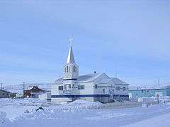 The Roman Catholic Church at Kugluktuk
See also
Notes
- ↑ Climate data was recorded at Coppermine from October 1930 to November 1977 and at Kugluktuk Airport from December 1977 to present.
References
- ↑ Nunavummiut elect new municipal leaders
- ↑ Election Results 2013 General Election at Elections Nunavut
- 1 2 3 Kugluktuk, HAM Nunavut (Census subdivision)
- 1 2 Kugluktuk Nunavut (Population centre)
- ↑ Elevation at airport. Canada Flight Supplement. Effective 0901Z 15 September 2016 to 0901Z 10 November 2016
- ↑ The 1982 Plebiscite on Division of the Northwest Territories: Regional Government and Federal Policy
- ↑ Peel, M. C. and Finlayson, B. L. and McMahon, T. A. (2007). "Updated world map of the Köppen–Geiger climate classification" (PDF). Hydrol. Earth Syst. Sci. 11: 1633–1644. doi:10.5194/hess-11-1633-2007. ISSN 1027-5606.
- 1 2 "Kugluktuk A *". Canadian Climate Normals 1981–2010. Environment Canada. Climate ID: 2300902. Retrieved 2014-04-30.
- 1 2 "February 1968". Canadian Climate Data. Environment Canada. Climate ID: 2300900. Retrieved 25 June 2016.
- ↑ "June 1934". Canadian Climate Data. Environment Canada. Climate ID: 2300900. Retrieved 25 June 2016.
- ↑ "December 1934". Canadian Climate Data. Environment Canada. Climate ID: 2300900. Retrieved 25 June 2016.
- ↑ "May 1941". Canadian Climate Data. Environment Canada. Climate ID: 2300900. Retrieved 25 June 2016.
- ↑ "February 1943". Canadian Climate Data. Environment Canada. Climate ID: 2300900. Retrieved 25 June 2016.
- ↑ "October 1943". Canadian Climate Data. Environment Canada. Climate ID: 2300900. Retrieved 25 June 2016.
- ↑ "January 1947". Canadian Climate Data. Environment Canada. Climate ID: 2300900. Retrieved 25 June 2016.
- ↑ "November 1948". Canadian Climate Data. Environment Canada. Climate ID: 2300900. Retrieved 25 June 2016.
- ↑ "March 1949". Canadian Climate Data. Environment Canada. Climate ID: 2300900. Retrieved 25 June 2016.
- ↑ "May 1952". Canadian Climate Data. Environment Canada. Climate ID: 2300900. Retrieved 25 June 2016.
- ↑ "March 1955". Canadian Climate Data. Environment Canada. Climate ID: 2300900. Retrieved 25 June 2016.
- ↑ "September 1957". Canadian Climate Data. Environment Canada. Climate ID: 2300900. Retrieved 25 June 2016.
- ↑ "April 1958". Canadian Climate Data. Environment Canada. Climate ID: 2300900. Retrieved 25 June 2016.
- ↑ "September 1970". Canadian Climate Data. Environment Canada. Climate ID: 2300900. Retrieved 25 June 2016.
- ↑ "November 1970". Canadian Climate Data. Environment Canada. Climate ID: 2300900. Retrieved 25 June 2016.
- ↑ "June 2013". Canadian Climate Data. Environment Canada. Climate ID: 2300902. Retrieved 25 June 2016.
- ↑ "August 2013". Canadian Climate Data. Environment Canada. Climate ID: 2300902. Retrieved 25 June 2016.
- Office of the Languages Commissioner of Nunavut - PDF Dialect Map
- Office of the Languages Commissioner of Nunavut - Writing systems
Further reading
| Wikimedia Commons has media related to Kugluktuk. |
- Dredge, L. A. Where the river meets the sea geology and landforms of the lower Coppermine River Valley and Kugluktuk, Nunavut. [Ottawa]: Geological Survey of Canada, 2001. ISBN 0-660-18550-4
- Pedersen, Lena, and Donna Stephania. Crime Prevention in Kugluktuk. Ottawa: Caledon Institute of Social Policy, 1999. ISBN 1-894159-61-6