Cambridge Bay
| Cambridge Bay Iqaluktuuttiaq ᐃᖃᓗᒃᑑᑦᑎᐊᖅ | |
|---|---|
| Hamlet | |
|
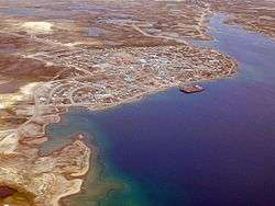
Aerial view of Cambridge Bay looking north | |
| Nickname(s): Cam Bay | |
 Cambridge Bay | |
| Coordinates: 69°07′02″N 105°03′11″W / 69.11722°N 105.05306°WCoordinates: 69°07′02″N 105°03′11″W / 69.11722°N 105.05306°W | |
| Country | Canada |
| Territory | Nunavut |
| Region | Kitikmeot Region |
| Electoral district | Cambridge Bay |
| Settled | 1921 |
| Incorporated (hamlet) | 1 April 1984 |
| Government[1][2] | |
| • Mayor | Jeannie Ehaloak |
| • Senior Administrative Officer | Stephen King |
| • MLA | Keith Peterson |
| Area[3][4] | |
| • Hamlet | 202.20 km2 (78.07 sq mi) |
| • Urban | 0.49 km2 (0.19 sq mi) |
| Elevation[5] | 31 m (102 ft) |
| Highest elevation | 183 m (600 ft) |
| Lowest elevation | 0 m (0 ft) |
| Population (2006)[3][4] | |
| • Hamlet | 1,477 |
| • Density | 7.3/km2 (19/sq mi) |
| • Urban | 1,147 |
| • Urban density | 2,300/km2 (6,100/sq mi) |
| Time zone | MST (UTC-7) |
| • Summer (DST) | MDT (UTC-6) |
| Canadian Postal code | X0B 0C0 |
| Area code(s) | 867 |
| Telephone Exchange | 983 |
| GNBC Code | CAPHL |
| NTS Map | 77D02 |
| Website | Official site |
Cambridge Bay (Inuinnaqtun: Iqaluktuuttiaq Inuktitut: ᐃᖃᓗᒃᑑᑦᑎᐊᖅ; 2006 population 1,477;[3] UA population 1,147[4]) is a hamlet located on Victoria Island in the Kitikmeot Region of Nunavut, Canada. It is named for Prince Adolphus, Duke of Cambridge, while the traditional Inuinnaqtun name for the area is Ikaluktuutiak (old orthography) or Iqaluktuttiaq (new orthography) meaning "good fishing place".
The traditional language of the area is Inuinnaqtun and is written using the Latin alphabet rather than the syllabics of the Inuktitut writing system. Like Kugluktuk, Bathurst Inlet and Umingmaktok, syllabics are rarely seen and used mainly by the Government of Nunavut.[6][7]
Cambridge Bay is the largest stop for passenger and research vessels traversing the Arctic Ocean's Northwest Passage,[8] a disputed area which the Government of Canada claims are Canadian Internal Waters, while other nations state they are either territorial waters or international waters.[9][10]
Location and population
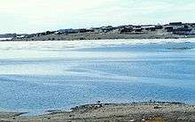
Situated between Dease Strait[11] and Queen Maud Gulf[12] on the southeast coast of Victoria Island (Kitlineq[13]), part of the Canadian Arctic Archipelago,[14] Cambridge Bay is a transportation and administrative centre for the Kitikmeot Region.[15] To the north of the community is Ferguson Lake (Inuinnaqtun: Tahiryuaq or Tahikyoak)[16] which flows into Wellington Bay via the Ekalluk River. The Ekalluk River is both an important commercial fishing and archaeological area,[17] and of particular importance is the short section of the river known as Iqaluktuuq.[18]
About 37 km (23 mi) west of the community lie the Finlayson Islands which were surveyed by Sir Richard Collinson on board the Enterprise during his search for Sir John Franklin's lost expedition.[19]
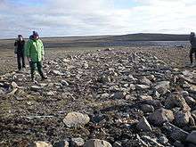
The area was a traditional hunting and fishing location and archaeological sites are often found. barren-ground caribou, muskox, Arctic char, lake trout and ringed seal were the primary, and remain important food sources. Situated east of Cambridge Bay is Ovayok Territorial Park, which includes the large esker known as Ovayok (Mount Pelly).[20]
As of the 2006 census the population was 1,477, an increase of 12.8% from the 2001 census.[3][21] The median age of the population is 26.3 and 69.3% of the people are over 15.[3] Both of these figures are slightly higher than the numbers for Nunavut as a whole (23.1 and 66.1%).[3] In 2006, 82.7% (Nunavut: 85.0%) of the population were listed as Aboriginal and 17.7% (Nunavut: 15%) as non-Aboriginal. Of the total population 78.9% (Nunavut: 84%) were Inuit, 1.7% (Nunavut: 0.4%) Métis and 1.4% (Nunavut: 0.3%) North American Indian.[22]
History
The first known people to occupy the area were the Pre-Dorset people, somewhere around 1800 BCE, about 4,000 years ago, and were seal and caribou hunters.[23] The next group to enter the area were a Paleo-Eskimo peoples known as the Dorset, who arrived approximately 500 CE. They were the first known people to have fished for the Arctic char.[24] The last of the Paleo-Eskimo people, who appeared here about 800 CE, were the Tuniit, and evidence of their living quarters can be seen close to Cambridge Bay. The Tuniit, who were known to the Inuit as giants, were taller and stronger than the Inuit, but were easily scared off.[25][26]
The next group to arrive were the Thule people, ancestors of the modern Inuit, who arrived in the area around 1250 CE from present day Alaska. The Thule people built food cache and stone houses in the area and were noted for their sophisticated tools.[27] Although there is no positive evidence it is suspected that the Thule may have interacted with the Tuniit.[25]
About 500 years ago, around 1500 CE, the modern Inuit made an appearance. Like the Thule they made use of caches, hunted caribou and fished for char. They also hunted seal from the ice in winter and returned to the land in spring. They were also known to make use of inukhuk and built igluit.[28] Although they had no collective name, the various groups of Inuit that made use of native copper for tools have since become known as Copper Inuit and are the same people that Vilhjalmur Stefansson called the Blond Eskimos.[29][30] The main groups that lived or interacted in the Cambridge Bay area were the Ekalluktogmiut (Iqaluktuurmiutat[18] or Ikaluktuurmiut), Ahiagmiut (Ahiarmiut), the Killinirmuit and the Umingmuktogmiut.[31]
The first Europeans to see it were Thomas Simpson in 1839 and John Rae in 1851. Richard Collinson wintered here in 1852/53. His ship came all the way from the Bering Strait. This was the furthest east of any large ship until Henry Larsen (explorer) in 1941. Cambridge Bay was the site of Royal Canadian Mounted Police (RCMP) and Hudson's Bay Company outposts established during the 1920s. Although at this point most Inuit would have continued the traditional lifestyle and only visited the area rather than live there permanently.[32] The HBC opened a post here in 1921, later than in most places, and built at the site now called the "old town".[12][32] In 1925 the HBC purchased the Maud, which they renamed the Baymaud, from the creditors of Arctic explorer, Roald Amundsen. The ship sailed to the Arctic in 1926 but it became stuck in the winter ice at Cambridge Bay. The ship was later anchored near the shore and used for various purposes including the first ever radio weather reports from the Arctic coast.[33] In 1930 the ship sank and, although some material was removed at the time, the ship is still visible.[33] A Norwegian plan to salvage the ship and return it to Norway, though initially denied an export permit, was granted on appeal, and was to be carried out in 2014 but was delayed to 2015 due to ice conditions preventing the arrival of salvage equipment until late in the open water season. The planned salvage of 2015 was delayed, however during the summer of 2016 the Maud was raised and prepared for return to Norway during the summer of 2017, where she will be displayed at a museum in Vollen.
In 1947 following World War II the Cambridge Bay LORAN Tower was built near the previous location of Cambridge Bay.[32] The construction of the LORAN tower involved hiring Inuit who, after the tower was complete, remained in the area.[32] The tower was demolished 5 August 2014.[34]
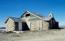
In 1954 construction was completed on the Roman Catholic Church. The church, Cambridge Bay's first, was constructed from local material using seal oil and sand as mortar, and was used for services until the 1960s.[32][35] In 2006, a large portion of the church, which had been designated a heritage site by the Hamlet Council, was destroyed by a fire which the RCMP said was deliberate.[35][36]
A Distant Early Warning Line site was established in 1955 and about 200 Inuit were hired to help in the construction.[32] The military presence and the services and economy this represented acted as a magnet for Inuit who had previously used the area as a temporary site for meeting, hunting, fishing and trade, and a permanent community was soon established across the bay in its current location.[32] Unlike the majority of the DEW Line radar sites which were abandoned or automated, this site which changed in 1989, known as CAM-MAIN, remains a manned operation, with about 18 people, as part of the North Warning System.[37][38]
Originally part of the Fort Smith Region, Northwest Territories, Cambridge Bay became the administrative centre for the Kitikmeot Region, Northwest Territories, and remained so after the 1999 division of the Northwest Territories. In 1982 a division plebiscite was held. Although about 80% of the population then living in what is now Nunavut voted in favour of division, Cambridge Bay was one of only two communities to vote against division. Kugluktuk, then called Coppermine, was the other.[39]
Canadian High Arctic Research Station
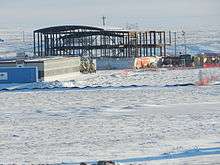
Cambridge Bay will be the location of the Canadian High Arctic Research Station (CHARS)[40] as announced by Prime Minister Stephen Harper on 24 August 2010.[41] This multidisciplinary station will operate year-round and is a keystone of Canada's Northern Strategy.[42] Its mandate is stated:
To be a world-class research station in Canada's Arctic that is on the cutting edge of Arctic issues. The Station will anchor a strong research presence in Canada's Arctic that serves Canada and the world. It will advance Canada's knowledge of the Arctic in order to improve economic opportunities, environmental stewardship, and the quality of life of Northerners and all Canadians.
Cambridge Bay was chosen after a feasibility study that also included Pond Inlet and Resolute as potential locations.[44] Prime Minister Harper announced that, starting in 2012, the Government of Canada would spend $142.4 million over a six-year period to build, equip and provision the station. Additionally, again starting in 2012 and spread over six years, the government would provide $46.2 million for the CHARS Science and Technology Program.[45] The prime minister stated that to provide for the continuing research and operations $26.5 million per year, beginning in 2018-19, would be made available.[46] It is expected that the station will provide 35 to 50 jobs. These jobs, which will be full-time, part-time and seasonal, will start in 2017 and run the Science and Technology Program as well as provide the day-to-day operations of the station. In addition it is expected that 150 jobs will be created during construction for local and other people throughout the north. However, some of these jobs will require the hiring of specialised people from southern locales.[47] Construction began in August 2014 and the station will be operational in July 2017 for Canada's 150th anniversary.[48]
Given that there is a lack of available housing in the hamlet the government will also be building units to house the permanent full-time staff. These should be constructed by 2017 when the station opens. Along with the housing units there will be two three-plexes on site to accommodate the part-time and seasonal workers which should be ready by 2015.[47]
Education
Several educational services are available, including daycare,[49] preschool, Kullik Elementary School, Killinik High School, and a public library[12] and museum located in the high school.[50] The community is also the regional centre for the Kitikmeot Campus of Nunavut Arctic College who oversee the Cambridge Bay Community Learning Centre. Courses range from Adult Basic Education to the Nunavut Teacher Education Program (NETP), which, in partnership with the University of Regina, is able to offer a Bachelor of Education.[51][52][53]
Land claims
The Kitikmeot Inuit Association, Nunavut Impact Review Board, and Nunavut Planning Commission have offices in Cambridge Bay, as well as the Lands and Resources Department of Nunavut Tunngavik Incorporated.[54][55][56][57]
Religion
There are three churches in Cambridge Bay: St. George's Anglican Church, which is part of the Diocese of Arctic,[58] Our Lady of the Arctic Roman Catholic Church, which is part of the Diocese of Mackenzie-Fort Smith,[59] and the Glad Tidings Pentecostal Church.[60]
Economy and infrastructure
There are several businesses in the community and these include a Northern Store which includes a Quick Stop, selling KFC and Pizza Hut products,[61] the Ikaluktutiak Co-operative, part of the Arctic Co-operatives Limited,[62] a branch of the Royal Bank of Canada[63] and a Canada Post postal service.[64] Other community businesses include Jago Services, plumbing and electrical,[65] Kitnuna, construction, mechanics shop, heating fuel and Kitikmeot Supplies, a hardware store,[66] Kalvik Enterprises and Nanook Woodworking, both construction companies[67][68] and Inukshuk Enterprises, a general contractor, who also operate a service garage[69]
There are three taxi services, one run by the Co-op, Go Cargo Taxi and Wolf Tracks Taxi.[70] There is a modern health centre in the community that opened in 2005 and in 2010 the birthing centre was opened.[71] There is a RCMP detachment in Cambridge Bay and the Kitikmeot Law Centre has its offices in the community.[72][73] There are two hotels, the Arctic Islands Lodge, run by the Co-op and the Green Row operated by Inukshuk Enterprises.[74][75]
Phone service is provided by Northwestel and, with their subsidiary Latitude Wireless, also handles cell phone coverage.[76][77] Buildings in Cambridge Bay, like in most Nunavut communities, have water and sewage tanks that require regular services by truck. These services along with garbage pick-up are done by the Hamlet.[78]
Media
Radio
| Frequency | Call sign | Branding | Format | Owner | Notes |
|---|---|---|---|---|---|
| FM 97.7 | CFBI-FM | – | Community radio | Cambridge Bay Communications Society | Broadcasts programming in English and Inuinnaqtun |
| FM 101.9 | CFFB-1-FM | CBC Radio One | Talk radio, public radio | Canadian Broadcasting Corporation | Rebroadcaster of CFFB (Iqaluit) |
| FM 105.1 | CBIN-FM | CBC Radio One | Talk radio, public radio | Canadian Broadcasting Corporation | Rebroadcaster of CHAK (Inuvik) |
Cambridge Bay is served by two CBC Radio One rebroadcasters to allow residents to hear Inuvialuktun language programming, which is the language spoken in Cambridge Bay, that is aired in the afternoons by CHAK.
Television
- Channel 9 – CBENT, CBC North went dark 31 July 2012[79]
- Channel 51 is a local channel run by the Kitikmeot Inuit Association featuring local and territorial films, videos and documentaries.
Cable television is available from the local Co-op[62] and satellite television from either Shaw Direct or Bell TV.

Internet services
- Explornet, satellite Internet service provided by CasCom[80]
- Northwestel High Speed Internet, DSL
- Polarnet, Internet Service provider for the Kitikmeot region[81]
- QINIQ, broadband Internet service provider for Nunavut
Transportation
Although Cambridge Bay lies on the Northwest Passage there are no passenger ships other than tourist cruises. Northern Transportation Company Limited, owned by NorTerra, and Nunavut Sealink and Supply, owned by Arctic Co-operatives Limited, provide annual sealift to the community.[82][83]
The only passenger services are through the Cambridge Bay Airport from which daily air service to Yellowknife, and to the other Kitikmeot Region communities with Canadian North or First Air.[84][85]
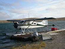
Charter and MEDIVAC (air ambulance) services are provided by Aqsaqniq Airways of Taloyoak. Aqsaqniq Airways is a joint venture between Aqsaqniq Limited, an Inuit company and majority shareholder, and Yellowknife based company Air Tindi, the minority shareholder.[86][87][88] Former MEDIVAC operator Adlair Aviation still operates charters in the region. In the summer floatplane charters are provided by DAL Aviation from the Cambridge Bay Water Aerodrome.[89]
In 2012, the roads of Cambridge Bay were imaged for Google Street View by a tricycle fitted with a camera system.[90] While Cambridge Bay has no cars (only snowmobiles, ATVs and trucks), Google responded to a proposal by Cambridge Bay resident Chris Kalluk to include Arctic communities in Street View in order to educate the rest of the world.[90] Through Google Street View, one can even enter the indoor swimming pool and have a look around.
Climate
Cambridge Bay has a polar climate, no month having an average temperature of 10 °C (50 °F) or higher, and is listed as ET on the Köppen climate classification.[91]
| Climate data for Cambridge Bay Airport | |||||||||||||
|---|---|---|---|---|---|---|---|---|---|---|---|---|---|
| Month | Jan | Feb | Mar | Apr | May | Jun | Jul | Aug | Sep | Oct | Nov | Dec | Year |
| Record high humidex | −5.0 | −9.7 | −4.1 | 3.9 | 10.5 | 25.3 | 30.8 | 28.6 | 16.3 | 5.8 | −1.4 | −3.5 | 30.8 |
| Record high °C (°F) | −4.9 (23.2) |
−9.4 (15.1) |
−4.0 (24.8) |
6.1 (43) |
11.5 (52.7) |
23.3 (73.9) |
28.9 (84) |
26.1 (79) |
16.4 (61.5) |
6.9 (44.4) |
0.0 (32) |
−3.4 (25.9) |
28.9 (84) |
| Average high °C (°F) | −28.5 (−19.3) |
−28.9 (−20) |
−25.3 (−13.5) |
−16.3 (2.7) |
−5.6 (21.9) |
5.8 (42.4) |
12.8 (55) |
9.8 (49.6) |
2.5 (36.5) |
−7.3 (18.9) |
−18.8 (−1.8) |
−24.9 (−12.8) |
−10.4 (13.3) |
| Daily mean °C (°F) | −32.0 (−25.6) |
−32.5 (−26.5) |
−29.3 (−20.7) |
−20.8 (−5.4) |
−9.3 (15.3) |
2.7 (36.9) |
8.9 (48) |
6.8 (44.2) |
0.3 (32.5) |
−10.4 (13.3) |
−22.3 (−8.1) |
−28.3 (−18.9) |
−13.9 (7) |
| Average low °C (°F) | −35.4 (−31.7) |
−36.1 (−33) |
−33.2 (−27.8) |
−25.3 (−13.5) |
−13.0 (8.6) |
−0.3 (31.5) |
4.9 (40.8) |
3.8 (38.8) |
−1.9 (28.6) |
−13.5 (7.7) |
−25.7 (−14.3) |
−31.8 (−25.2) |
−17.3 (0.9) |
| Record low °C (°F) | −52.8 (−63) |
−50.6 (−59.1) |
−48.3 (−54.9) |
−42.8 (−45) |
−35.0 (−31) |
−17.8 (0) |
−1.7 (28.9) |
−8.9 (16) |
−17.2 (1) |
−33.0 (−27.4) |
−43.9 (−47) |
−49.4 (−56.9) |
−52.8 (−63) |
| Record low wind chill | −73.4 | −72.6 | −69.8 | −60.1 | −43.2 | −29.2 | −7.9 | −13.1 | −28.6 | −49.4 | −60.7 | −66.3 | −73.4 |
| Average precipitation mm (inches) | 5.8 (0.228) |
4.9 (0.193) |
7.1 (0.28) |
5.7 (0.224) |
7.0 (0.276) |
13.6 (0.535) |
24.1 (0.949) |
25.7 (1.012) |
19.1 (0.752) |
14.7 (0.579) |
8.0 (0.315) |
6.1 (0.24) |
141.7 (5.579) |
| Average rainfall mm (inches) | 0.0 (0) |
0.0 (0) |
0.0 (0) |
0.0 (0) |
1.0 (0.039) |
10.0 (0.394) |
23.9 (0.941) |
23.9 (0.941) |
12.7 (0.5) |
0.6 (0.024) |
0.0 (0) |
0.0 (0) |
72.1 (2.839) |
| Average snowfall cm (inches) | 6.7 (2.64) |
5.9 (2.32) |
8.4 (3.31) |
6.9 (2.72) |
7.2 (2.83) |
3.8 (1.5) |
0.1 (0.04) |
1.8 (0.71) |
6.8 (2.68) |
15.9 (6.26) |
9.8 (3.86) |
6.8 (2.68) |
80.2 (31.57) |
| Average precipitation days (≥ 0.2 mm) | 7.3 | 6.8 | 9.2 | 6.8 | 7.1 | 8.0 | 10.7 | 13.1 | 11.9 | 12.1 | 9.0 | 7.9 | 109.8 |
| Average rainy days (≥ 0.2 mm) | 0.0 | 0.0 | 0.0 | 0.0 | 0.9 | 5.9 | 10.7 | 12.5 | 7.1 | 0.6 | 0.0 | 0.0 | 37.8 |
| Average snowy days (≥ 0.2 cm) | 7.4 | 6.9 | 9.8 | 7.1 | 7.3 | 3.4 | 0.1 | 1.2 | 6.3 | 12.5 | 9.5 | 8.3 | 79.8 |
| Average relative humidity (%) | 65.3 | 66.4 | 70.5 | 76.2 | 83.8 | 77.2 | 68.2 | 73.6 | 82.3 | 86.2 | 76.5 | 70.0 | 74.7 |
| Mean monthly sunshine hours | 7.3 | 73.7 | 169.6 | 275.9 | 245.1 | 291.6 | 333.8 | 186.6 | 71.7 | 56.8 | 17.6 | 0.0 | 1,729.7 |
| Percent possible sunshine | 11.7 | 35.4 | 47.1 | 57.7 | 36.6 | 40.5 | 45.9 | 33.6 | 17.8 | 20.0 | 13.5 | 0.0 | 30.0 |
| Source: Environment Canada Canadian Climate Normals 1981–2010[91] | |||||||||||||
The sun is continuously below the horizon, polar night, from approximately 30 November to 11 January and above the horizon, midnight sun, 19 May to 22 July.[92]
Notable residents
- Stephen Angulalik, an Ahiarmiut fur trader and trading post operator at Kuugjuaq (Perry River).[93]
- Bill Lyall, was a member of the 8th Northwest Territories Legislative Assembly from 1975–1979, he was later awarded the Order of Canada for his work with the Arctic Cooperative[94][95]
- Helen Maksagak, the first woman and the first Inuk to be Commissioner of the Northwest Territories (1995–1999) and the first Commissioner of Nunavut (1999–2000), she was awarded the Order of Canada for her work.[96]
- Kelvin Ng, won the 1995 election and the first Nunavut election in 1999 representing the Cambridge Bay riding.[97]
- Red Pedersen, worked with Stephen Angulalik while at Perry River[98] and was elected in both the 1993 NWT election and the 1997 NWT election.
- Keith Peterson, is the current member of Legislative Assembly of Nunavut having won in the 2004 election and was acclaimed in the 2008 election.[97][99] Peterson is the current Minister of Finance and Minister of Health and Social Services.[100]
- Tanya Tagaq (Tanya Tagaq Gillis), an Inuk throat singer and painter[101][102] She has performed at Folk on the Rocks in 2005 and 2010, toured with Björk and released four albums, Sinaa, Auk/Blood, Anuraaqtuq and Animism.[103][104][105]
- Kane Tologanak, elected to represent the Central Arctic in the 1979 election.
See also
References
- ↑ Nunavummiut elect new municipal leaders
- ↑ Results for the constituency of Cambridge Bay at Elections Nunavut
- 1 2 3 4 5 6 "2006 Community Profiles". Retrieved 8 June 2007.
- 1 2 3 "Population and dwelling counts for Urban Area (2006 Census)". Statistics Canada. March 2007. Retrieved 17 February 2008.
- ↑ Elevation at airport. Canada Flight Supplement. Effective 0901Z 15 September 2016 to 0901Z 10 November 2016
- ↑ Office of the Languages Commissioner of Nunavut – PDF Dialect Map Archived 2 April 2007 at the Wayback Machine.
- ↑ Office of the Languages Commissioner of Nunavut – Writing systems Archived 13 September 2005 at the Wayback Machine.
- ↑ "Cambridge Bay hosts 4 Northwest Passage-bound yachts". Canada: CBC. 18 August 2009. Retrieved 20 November 2011.
- ↑ "TP 14202 E: Interpretation". Transport Canada. 27 November 2007. Retrieved 18 January 2008.
- ↑ Rob Huebert (Winter 2001). "Climate Change and Canadian Sovereignty in the Northwest Passage". ISUMA: 86–94. Archived from the original on 31 January 2002. Retrieved 13 January 2008.
- ↑ Pharand, D.; Legault, L.H. (1984). The Northwest Passage: Arctic Straits. Martinus Nijhoff Publishers. p. 14. ISBN 90-247-2979-3.
- 1 2 3 "Cambridge bay, Nunavut". Kitikmeot School Operations. Archived from the original on 13 January 2010.
- ↑ "Society-COPPER-ESKIMO". ukc.ac.uk. Retrieved 1 November 2008.
- ↑ M.J. Dunbar, Peter Adams. "Arctic Archipelago". Thecanadianencyclopedia.com. Retrieved 20 November 2011.
- ↑ Cambridge Bay at the Nunavut Planning Commission
- ↑ Tologanak, Navalik (20 August 2007). "Traditional names still remain". Northern News Services Online. Retrieved 24 January 2008.
- ↑ "Cambridge Bay Arctic Char" (PDF). Retrieved 20 November 2011.
- 1 2 "Iqaluktuurmiutat: Life at Iqaluktuuq" (PDF). Retrieved 20 November 2011.
- ↑ Collinson, Richard; Collinson, T.B. (1889). Journal of H.M.S. Enterprise, on the expedition in search of Sir John Franklin's ships by Behring Strait, 1850–55. London: Low, Marston, Searle, & Rivington. pp. 286–288. OCLC 22079420.
- ↑ Ovayok at Nunavut Parks
- ↑ "2001 Community Profiles". Retrieved 5 July 2010.
- ↑ "2006 Aboriginal Population Profile". 2.statcan.ca. 6 December 2010. Retrieved 20 November 2011.
- ↑ "Pre-Dorset – 1800 to 500 BC". Kitikmeotheritage.ca. Retrieved 20 November 2011.
- ↑ "Early/Middle Dorset – 500 BC to 800 AD". Kitikmeotheritage.ca. Retrieved 20 November 2011.
- 1 2 "Late Dorset – 800 AD to 1250 AD". Kitikmeotheritage.ca. Retrieved 20 November 2011.
- ↑ 101. Nunavut Handbook, Qaummaarviit Historic Park
- ↑ "Thule Inuit – 1250 AD to 1500 AD". Kitikmeotheritage.ca. Retrieved 20 November 2011.
- ↑ "Modern Inuit – 1500 AD to Today". Kitikmeotheritage.ca. Retrieved 20 November 2011.
- ↑ "The Copper Inuit (Ulukhaktokmiut) of Holman". The Ohio State University. 26 November 2007. Retrieved 24 August 2008.
- ↑ "DNA tests debunk blond Inuit legend". Canada: CBC. 28 October 2003. Retrieved 20 November 2011.
- ↑ "Kitikmeot Regional Groups". Kitikmeotheritage.ca. Retrieved 20 November 2011.
- 1 2 3 4 5 6 7 "Bringing our Past into the Future". Museevirtuel.ca. 10 September 1954. Retrieved 11 December 2011.
- 1 2 Cambridge Bay at the Prince of Wales Northern Heritage Centre
- ↑ Cambridge Bay residents bid farewell to a trusty old friend
- 1 2 "Landmark church burns in Nunavut". Sikunews.com. Retrieved 20 November 2011.
- ↑ "Hamlet of Cambridge Bay By-Law No. 96" (PDF). Retrieved 20 November 2011.
- ↑ "The DEW Line". Lswilson.ca. Retrieved 20 November 2011.
- ↑ Arctic Trip – North Warning System Archived 7 March 2011 at the Wayback Machine.
- ↑ "The 1982 Plebiscite on Division of the Northwest Territories: Regional Government and Federal Policy" (PDF). Retrieved 20 November 2011.
- ↑ Canadian High Arctic Research Station (CHARS)
- ↑ Timeline
- ↑ Northern Strategy
- ↑ CHARS Mandate
- ↑ Location and Siting
- ↑ Science and Technology Program
- ↑ Frequently Asked Questions
- 1 2 Frequently Asked Questions - Employment
- ↑ Frequently Asked Questions - Design and Construction
- ↑ "Daycare". Cambridgebay.ca. Retrieved 20 November 2011.
- ↑ "Kitikmeot Heritage Society". Kitikmeotheritage.ca. Retrieved 20 November 2011.
- ↑ "Kitikmeot Campus". Arcticcollege.ca. Retrieved 20 November 2011.
- ↑ "Programs and Courses". Arcticcollege.ca. Retrieved 20 November 2011.
- ↑ "Nunavut Teacher Education Program". Arcticcollege.ca. Retrieved 20 November 2011.
- ↑ "Kitikmeot Inuit Association". Polarnet.ca. Retrieved 20 November 2011.
- ↑ "Nunavut Impact Review Board". Nirb.ca. Retrieved 20 November 2011.
- ↑ "Nunavut Planning Commission". Nunavut.ca. Retrieved 20 November 2011.
- ↑ NTI – Lands and Resources Department
- ↑ "St. George's Cambridge Bay (Ikaluktutiak), NU Diocese of the Arctic". Arcticnet.org. Retrieved 20 November 2011.
- ↑ Delta and Arctic Coastal Regions
- ↑ "Churches & Religious". Cambridgebay.ca. Retrieved 20 November 2011.
- ↑ "Restaurants". Cambridgebay.ca. Retrieved 20 November 2011.
- 1 2 "Ikaluktutiak Co-operative Limited". Arcticco-op.com. Retrieved 20 November 2011.
- ↑ "Bank". Cambridgebay.ca. Retrieved 20 November 2011.
- ↑ "Post Office". Cambridgebay.ca. Retrieved 20 November 2011.
- ↑ "Jago Services Incorporated". Ic.gc.ca. Retrieved 20 November 2011.
- ↑ "Kitnuna". Kitikmeotcorp.ca. Retrieved 20 November 2011.
- ↑ "Kalvik Enterprises". Phonepages.ca. Retrieved 20 November 2011.
- ↑ "Nanook Woodworking". Manta.com. Retrieved 20 November 2011.
- ↑ "Inukshuk Enterprises". Nni.gov.nu.ca. 17 January 2011. Retrieved 20 November 2011.
- ↑ Northwestel phone book
- ↑ "Cambridge Bay celebrates birth, closer to home". Nunatsiaqonline.ca. 22 April 2010. Retrieved 20 November 2011.
- ↑ "Police". Cambridgebay.ca. Retrieved 20 November 2011.
- ↑ "Legal". Cambridgebay.ca. Retrieved 20 November 2011.
- ↑ "Arctic Islands Lodge Inns North Hotel". Cambridgebayhotel.com. 10 August 2007. Retrieved 20 November 2011.
- ↑ "Green Row Executive Suites". Nunavuttourism.com. Retrieved 20 November 2011.
- ↑ "Northwestel". Nwtel.ca. Retrieved 20 November 2011.
- ↑ "Latitude Wireless". Nwtel.ca. Retrieved 20 November 2011.
- ↑ "Municipal services". Cambridgebay.ca. Retrieved 20 November 2011.
- ↑ Query the REC's Canadian station database for CFFB-TV
- ↑ "Explornet". CasCom. Retrieved 13 March 2015.
- ↑ "Polarnet". Polarnet.ca. Retrieved 20 November 2011.
- ↑ Northern Transportation Company Limited
- ↑ "Nunavut Sealink and Supply". Arcticco-op.com. 4 June 2001. Retrieved 20 November 2011.
- ↑ Canadian North Route Map and Flight Schedule
- ↑ "First Air". Firstair.ca. Retrieved 20 November 2011.
- ↑ Aqsaqniq Airways Ltd.
- ↑ Inuit Firm Registry Database – Aqsaqniq Ltd.
- ↑ Inuit Firm Registry Database – Aqsaqniq Airways Ltd.
- ↑ "DAL Aviation at the High Arctic Lodge". Higharctic.com. 13 January 2011. Retrieved 20 November 2011.
- 1 2 Ian Austen (22 August 2012). "Coming Soon, Google Street View of a Canadian Village You'll Never Drive To". New York Times. Retrieved 24 August 2012.
- 1 2 "Cambridge Bay A *". Canadian Climate Normals 1981–2010. Environment Canada. Climate ID: 2400600. Retrieved 2014-04-30.
- ↑ Sunrise/Sunset/Sun Angle Calculator at the National Research Council (Canada)
- ↑ "Introducing Stephen Angulalik". Kitikmeotheritage.ca. Retrieved 20 November 2011.
- ↑ "William L. Lyall, C.M". Archive.gg.ca. 30 April 2009. Retrieved 20 November 2011.
- ↑ "The Lyalls of Taloyoak". Nnsl.com. Retrieved 20 November 2011.
- ↑ "Helen Mamayaok Maksagak, C.M., LL.D". Archive.gg.ca. 30 April 2009. Retrieved 20 November 2011.
- 1 2 "Nunavut Votes 2004 Cambridge Bay Profile". Canada: CBC. 16 February 2004. Retrieved 20 November 2011.
- ↑ "Red Pedersen". Kitikmeotheritage.ca. Retrieved 20 November 2011.
- ↑ "Cambridge Bay". Elections.nu.ca. Retrieved 20 November 2011.
- ↑
- ↑ "Tanya Tagaq Gillis". Centre for Contemporary Canadian Art-Centre de l'art contemporain canadien. Retrieved 13 October 2009.
- ↑ "Nunavut – 2003". Nwtel.ca. Retrieved 20 November 2011.
- ↑ "Photos from the 2005 Folk on the Rocks Festival". Folkontherocks.com. Retrieved 20 November 2011.
- ↑ Folk on the Rocks 2010 lineup
- ↑ "Tanya 'Tagaq' Gillis & Celina Kalluk". Thepuredrop.com.au. Retrieved 20 November 2011.
Further reading
- 2007. "Mosaic – Snow Sprints in Cambridge Bay, Nunavut – Photography by Finn O'Hara". Canadian Geographic. 127, no. 2: 100.
- Barlishen, W. J., and T. N. Webber. A History of the Development of Commercial Fishing in the Cambridge Bay Area of the Northwest Territories. 1973.
- Canada. Cambridge Bay. Ottawa: Environment Canada, Atmospheric Environment Service, 1984. ISBN 0-660-52564-X
- Canada Centre for Mineral and Energy Technology, and Resource Ventures Incorporated. Cambridge Bay Wind Farm. [Ottawa]: The Branch, 1997.
- Gajda, Roman. Terrain and Site Analysis of Cambridge Bay, N.W.T. Ottawa: Dept. of Mines and Technical Surveys, Geographical Branch, 1962.
- Hill, Steven Grant. Ethnography of Inuit Elderly in a Present Day Arctic Settlement, Cambridge Bay, N.W.T. Ottawa: National Library of Canada, 1990. ISBN 0-315-51565-1.
External links
| Wikimedia Commons has media related to Cambridge Bay. |
- Official website
- Maps of the region including traditional names
- Bringing our Past into the Future
- Images of Cambridge Bay Youth
- Cambridge Bay Streetview Gallery