LaCenter, Kentucky
| LaCenter, Kentucky | |
|---|---|
| City | |
 Location of LaCenter, Kentucky | |
| Coordinates: 37°4′29″N 88°58′30″W / 37.07472°N 88.97500°WCoordinates: 37°4′29″N 88°58′30″W / 37.07472°N 88.97500°W | |
| Country | United States |
| State | Kentucky |
| County | Ballard |
| Area | |
| • Total | 0.6 sq mi (1.6 km2) |
| • Land | 0.6 sq mi (1.6 km2) |
| • Water | 0.0 sq mi (0.0 km2) |
| Elevation | 367 ft (112 m) |
| Population (2010) | |
| • Total | 1,009 |
| • Density | 1,665/sq mi (643.0/km2) |
| Time zone | Central (CST) (UTC-6) |
| • Summer (DST) | CDT (UTC-5) |
| ZIP code | 42056 |
| Area code(s) | 270 & 364 |
| FIPS code | 21-43336 |
| GNIS feature ID | 0495882 |
LaCenter,[1][2] formerly and often informally written as La Center, is a home rule-class city[3] in Ballard County, Kentucky, in the United States. The population was 1,009 at the 2010 census,[4] making it the most populous community in the county. It is part of the Paducah micropolitan area.
Geography
LaCenter is located at 37°4′29″N 88°58′30″W / 37.07472°N 88.97500°W (37.074782, -88.975091).[5] It is geographically significant because of its proximity to the confluence of the Ohio and Mississippi rivers. According to the United States Census Bureau, the city has a total area of 0.62 square miles (1.6 km2), all land.[4]
History
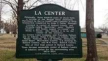
The Kentucky Secretary of State is unclear upon the city's date of incorporation,[1] but the LaCenter Woman's Club claims it was originally named Merriville, then Ballard Center, then finally La Center after its purchase by the La Center Land Company in 1902.[6]
Demographics
| Historical population | |||
|---|---|---|---|
| Census | Pop. | %± | |
| 1910 | 426 | — | |
| 1920 | 627 | 47.2% | |
| 1930 | 637 | 1.6% | |
| 1940 | 591 | −7.2% | |
| 1950 | 593 | 0.3% | |
| 1960 | 682 | 15.0% | |
| 1970 | 1,044 | 53.1% | |
| 1980 | 1,044 | 0.0% | |
| 1990 | 1,040 | −0.4% | |
| 2000 | 1,038 | −0.2% | |
| 2010 | 1,009 | −2.8% | |
| Est. 2015 | 1,005 | [7] | −0.4% |
As of the census[9] of 2000, there were 1,038 people, 419 households, and 261 families residing in the city. The population density was 1,351.0 people per square mile (520.5/km²). There were 492 housing units at an average density of 640.4 per square mile (246.7/km²). The racial makeup of the city was 89.40% White, 9.06% African American, 0.10% Native American, 0.29% Asian, and 1.16% from two or more races. Hispanic or Latino of any race were 0.58% of the population.
There were 419 households out of which 29.4% had children under the age of 18 living with them, 45.8% were married couples living together, 13.1% had a female householder with no husband present, and 37.7% were non-families. 35.1% of all households were made up of individuals and 21.2% had someone living alone who was 65 years of age or older. The average household size was 2.26 and the average family size was 2.90.
In the city the population was spread out with 23.2% under the age of 18, 7.0% from 18 to 24, 23.9% from 25 to 44, 19.3% from 45 to 64, and 26.6% who were 65 years of age or older. The median age was 42 years. For every 100 females there were 80.5 males. For every 100 females age 18 and over, there were 71.0 males.
The median income for a household in the city was $27,188, and the median income for a family was $36,250. Males had a median income of $32,813 versus $20,417 for females. The per capita income for the city was $14,317. About 13.9% of families and 16.5% of the population were below the poverty line, including 25.9% of those under age 18 and 12.2% of those age 65 or over.
References
- 1 2 Commonwealth of Kentucky. Office of the Secretary of State. Land Office. "LaCenter, Kentucky". Accessed 5 Aug 2013.
- ↑ Commonwealth of Kentucky. Ballard County. "LaCenter". Accessed 5 Aug 2013.
- ↑ "Summary and Reference Guide to House Bill 331 City Classification Reform" (PDF). Kentucky League of Cities. Retrieved December 30, 2014.
- 1 2 "Geographic Identifiers: 2010 Demographic Profile Data (G001): La Center city, Kentucky". U.S. Census Bureau, American Factfinder. Retrieved November 18, 2013.
- ↑ "US Gazetteer files: 2010, 2000, and 1990". United States Census Bureau. 2011-02-12. Retrieved 2011-04-23.
- ↑ La Center Woman's Club. Historical Marker.
- ↑ "Annual Estimates of the Resident Population for Incorporated Places: April 1, 2010 to July 1, 2015". Retrieved July 2, 2016.
- ↑ "Census of Population and Housing". Census.gov. Retrieved June 4, 2015.
- ↑ "American FactFinder". United States Census Bureau. Retrieved 2008-01-31.
External links
- City of LaCenter Elected Officials at Ballard County website
Municipalities and communities of Ballard County, Kentucky, United States | ||
|---|---|---|
| Cities | 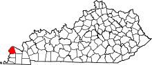 | |
| CDPs | ||
| Unincorporated communities | ||