La Union, New Mexico
| La Union, New Mexico | |
|---|---|
| Census-designated place | |
 La Union | |
| Coordinates: 31°57′02″N 106°39′42″W / 31.95056°N 106.66167°WCoordinates: 31°57′02″N 106°39′42″W / 31.95056°N 106.66167°W | |
| Country | United States |
| State | New Mexico |
| County | Doña Ana |
| Area[1] | |
| • Total | 4.143 sq mi (10.73 km2) |
| • Land | 4.143 sq mi (10.73 km2) |
| • Water | 0 sq mi (0 km2) |
| Elevation | 3,799 ft (1,158 m) |
| Population (2010)[1] | |
| • Total | 1,106 |
| • Density | 270/sq mi (100/km2) |
| Time zone | Mountain (MST) (UTC-7) |
| • Summer (DST) | MDT (UTC-6) |
| Area code(s) | 575 |
| GNIS feature ID | 920626[2] |
La Union is a census-designated place in Doña Ana County, New Mexico, United States. Its population was 1,106 as of the 2010 census.[1] New Mexico State Road 182 connects the community to New Mexico State Road 28.
Geography
La Union is located at 32°58′50″N 107°18′27″W / 32.980625°N 107.307469°W. According to the U.S. Census Bureau, the community has an area of 0.979 square miles (2.54 km2), all of it land.[1]
Education
The Gadsden Independent School District operates public schools, including La Union Elementary School.[3]
Local attractions
References
- 1 2 3 4 "2010 Census Gazetteer Files - Places: New Mexico". U.S. Census Bureau. Retrieved August 21, 2014.
- ↑ "La Union". Geographic Names Information System. United States Geological Survey.
- ↑ "Elementary schools." Gadsden Independent School District. Retrieved on August 19, 2015.
Municipalities and communities of Doña Ana County, New Mexico, United States | ||
|---|---|---|
| Cities | 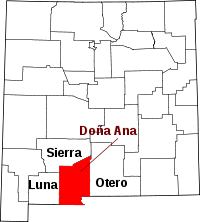 | |
| Town | ||
| Village | ||
| CDPs | ||
| Ghost towns | ||
This article is issued from Wikipedia - version of the 11/4/2015. The text is available under the Creative Commons Attribution/Share Alike but additional terms may apply for the media files.