Labette, Kansas
| Labette, Kansas | |
|---|---|
| City | |
 Location within Labette County and Kansas | |
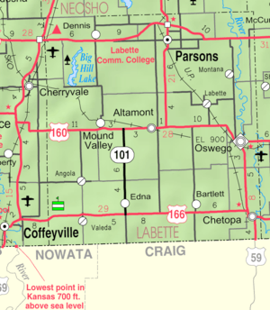 KDOT map of Labette County (legend) | |
| Coordinates: 37°13′49″N 95°11′2″W / 37.23028°N 95.18389°WCoordinates: 37°13′49″N 95°11′2″W / 37.23028°N 95.18389°W | |
| Country | United States |
| State | Kansas |
| County | Labette |
| Area[1] | |
| • Total | 0.22 sq mi (0.57 km2) |
| • Land | 0.22 sq mi (0.57 km2) |
| • Water | 0 sq mi (0 km2) |
| Elevation | 866 ft (264 m) |
| Population (2010)[2] | |
| • Total | 78 |
| • Estimate (2012[3]) | 77 |
| • Density | 354.5/sq mi (136.9/km2) |
| Time zone | Central (CST) (UTC-6) |
| • Summer (DST) | CDT (UTC-5) |
| ZIP code | 67356 |
| Area code(s) | 620 |
| FIPS code | 20-37375[4] |
| GNIS feature ID | 0469451[5] |
Labette is a city in Labette County, Kansas, United States. As of the 2010 census, the city population was 78.[6]
History
There have been three separate towns with the name Labette in Labette County since 1866.[7] The present one was founded in 1870.[8] It was named for Pierre Labette, a pioneer settler.[9]
Labette was a station on the Missouri–Kansas–Texas Railroad.[10]
Geography
Labette is located at 37°13′49″N 95°11′2″W / 37.23028°N 95.18389°W (37.230391, -95.183793).[11] According to the United States Census Bureau, the city has a total area of 0.22 square miles (0.57 km2), all land.[1]
Demographics
| Historical population | |||
|---|---|---|---|
| Census | Pop. | %± | |
| 1920 | 207 | — | |
| 1930 | 141 | −31.9% | |
| 1940 | 140 | −0.7% | |
| 1950 | 145 | 3.6% | |
| 1960 | 114 | −21.4% | |
| 1970 | 105 | −7.9% | |
| 1980 | 123 | 17.1% | |
| 1990 | 74 | −39.8% | |
| 2000 | 68 | −8.1% | |
| 2010 | 78 | 14.7% | |
| Est. 2015 | 75 | [12] | −3.8% |
| U.S. Decennial Census | |||
2010 census
As of the census[2] of 2010, there were 78 people, 32 households, and 21 families residing in the city. The population density was 354.5 inhabitants per square mile (136.9/km2). There were 36 housing units at an average density of 163.6 per square mile (63.2/km2). The racial makeup of the city was 98.7% White and 1.3% Native American.
There were 32 households of which 28.1% had children under the age of 18 living with them, 62.5% were married couples living together, 3.1% had a male householder with no wife present, and 34.4% were non-families. 34.4% of all households were made up of individuals and 12.5% had someone living alone who was 65 years of age or older. The average household size was 2.44 and the average family size was 3.05.
The median age in the city was 39.5 years. 21.8% of residents were under the age of 18; 8.9% were between the ages of 18 and 24; 25.7% were from 25 to 44; 32.1% were from 45 to 64; and 11.5% were 65 years of age or older. The gender makeup of the city was 50.0% male and 50.0% female.
2000 census
As of the census[4] of 2000, there were 68 people, 30 households, and 23 families residing in the city. The population density was 303.7 people per square mile (119.3/km²). There were 34 housing units at an average density of 151.8 per square mile (59.7/km²). The racial makeup of the city was 100.00% White.
There were 30 households out of which 20.0% had children under the age of 18 living with them, 70.0% were married couples living together, 6.7% had a female householder with no husband present, and 23.3% were non-families. 20.0% of all households were made up of individuals and 10.0% had someone living alone who was 65 years of age or older. The average household size was 2.27 and the average family size was 2.61.
In the city the population was spread out with 17.6% under the age of 18, 5.9% from 18 to 24, 20.6% from 25 to 44, 44.1% from 45 to 64, and 11.8% who were 65 years of age or older. The median age was 49 years. For every 100 females there were 94.3 males. For every 100 females age 18 and over, there were 86.7 males.
The median income for a household in the city was $25,000, and the median income for a family was $38,750. Males had a median income of $26,250 versus $16,875 for females. The per capita income for the city was $13,677. There were 14.3% of families and 24.6% of the population living below the poverty line, including 60.0% of under eighteens and none of those over 64.
References
- 1 2 "US Gazetteer files 2010". United States Census Bureau. Retrieved 2012-07-06.
- 1 2 "American FactFinder". United States Census Bureau. Retrieved 2012-07-06.
- ↑ "Population Estimates". United States Census Bureau. Retrieved 2013-05-29.
- 1 2 "American FactFinder". United States Census Bureau. Retrieved 2008-01-31.
- ↑ "US Board on Geographic Names". United States Geological Survey. 2007-10-25. Retrieved 2008-01-31.
- ↑ "2010 City Population and Housing Occupancy Status". U.S. Census Bureau. Retrieved March 18, 2012.
- ↑ Case, Nelson (1893). History of Labette County, Kansas: From the First Settlement to the Close of 1892. Crane & Company. p. 130.
- ↑ Blackmar, Frank Wilson (1912). Kansas: A Cyclopedia of State History. Standard Publishing Company. p. 82.
- ↑ "Profile for Labette, Kansas". ePodunk. Retrieved 12 June 2014.
- ↑ Gannett, Henry (1898). A Gazetteer of Kansas. Govt. Print. Off. p. 127.
- ↑ "US Gazetteer files: 2010, 2000, and 1990". United States Census Bureau. 2011-02-12. Retrieved 2011-04-23.
- ↑ "Annual Estimates of the Resident Population for Incorporated Places: April 1, 2010 to July 1, 2015". Retrieved July 2, 2016.
Further reading
- Labette County
- History of Labette County, Kansas, and Representative Citizens; Nelson Case; Biographical Publishing Company; 846 pages; 1901. (Download 50MB PDF eBook)
- Kansas
- History of the State of Kansas; William G. Cutler; A.T. Andreas Publisher; 1883. (Online HTML eBook)
- Kansas : A Cyclopedia of State History, Embracing Events, Institutions, Industries, Counties, Cities, Towns, Prominent Persons, Etc; 3 Volumes; Frank W. Blackmar; Standard Publishing Co; 944 / 955 / 824 pages; 1912. (Volume1 - Download 54MB PDF eBook),(Volume2 - Download 53MB PDF eBook), (Volume3 - Download 33MB PDF eBook)
External links
| Wikimedia Commons has media related to Labette, Kansas. |
- City
- Schools
- USD 506, local school district
- Maps
- Labette City Map, KDOT
Municipalities and communities of Labette County, Kansas, United States | ||
|---|---|---|
| Cities | 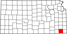 | |
| Unincorporated communities | ||
| Townships |
| |