Columbia County, Florida
| Columbia County, Florida | |
|---|---|
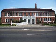
.jpg) Columbia County Courthouse in Lake City | |
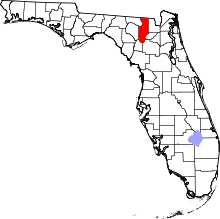 Location in the U.S. state of Florida | |
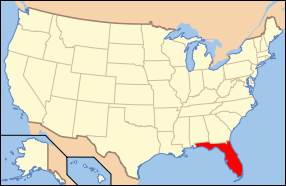 Florida's location in the U.S. | |
| Founded | February 4, 1832 |
| Seat | Lake City |
| Largest city | Lake City |
| Area | |
| • Total | 801 sq mi (2,075 km2) |
| • Land | 798 sq mi (2,067 km2) |
| • Water | 3.8 sq mi (10 km2), 0.5% |
| Population (est.) | |
| • (2015) | 68,348 |
| • Density | 85/sq mi (33/km²) |
| Congressional district | 3rd |
| Time zone | Eastern: UTC-5/-4 |
| Website |
www |
Columbia County county located in the U.S. state of Florida. As of the 2010 census, the population was 67,531.[1] Its county seat is Lake City.[2]
Columbia County comprises the Lake City, FL Micropolitan Statistical Area, which is included in the Gainesville-Lake City, FL Combined Statistical Area.
History
Columbia County was created in 1832. It took the name of Columbia, the poetic form for the United States.[3]
In 1958, the Columbia Amateur Radio Society was formed. This was a group of amateur radio operators that enjoyed the ability to communicate all over the world. This radio club still exists today.[4]
Geography
According to the U.S. Census Bureau, the county has a total area of 801 square miles (2,070 km2), of which 798 square miles (2,070 km2) is land and 3.8 square miles (9.8 km2) (0.5%) is water.[5]
Adjacent counties
- Echols County, Georgia - north
- Clinch County, Georgia - northeast
- Baker County - east
- Union County - southeast
- Alachua County - south
- Gilchrist County - southwest
- Suwannee County - west
- Hamilton County - northwest
National protected area
- Osceola National Forest (part)
Demographics
| Historical population | |||
|---|---|---|---|
| Census | Pop. | %± | |
| 1840 | 2,102 | — | |
| 1850 | 4,808 | 128.7% | |
| 1860 | 4,646 | −3.4% | |
| 1870 | 7,335 | 57.9% | |
| 1880 | 9,589 | 30.7% | |
| 1890 | 12,877 | 34.3% | |
| 1900 | 17,094 | 32.7% | |
| 1910 | 17,689 | 3.5% | |
| 1920 | 14,290 | −19.2% | |
| 1930 | 14,638 | 2.4% | |
| 1940 | 16,859 | 15.2% | |
| 1950 | 18,216 | 8.0% | |
| 1960 | 20,077 | 10.2% | |
| 1970 | 25,250 | 25.8% | |
| 1980 | 35,399 | 40.2% | |
| 1990 | 42,613 | 20.4% | |
| 2000 | 56,513 | 32.6% | |
| 2010 | 67,531 | 19.5% | |
| Est. 2015 | 68,348 | [6] | 1.2% |
| U.S. Decennial Census[7] 1790-1960[8] 1900-1990[9] 1990-2000[10] 2010-2015[1] | |||
As of the census[11] of 2000, there were 56,513 people, 20,925 households, and 14,919 families residing in the county. The population density was 71 people per square mile (27/km²). There were 23,579 housing units at an average density of 30 per square mile (11/km²). The racial makeup of the county was 79.72% White, 17.03% Black or African American, 0.53% Native American, 0.67% Asian, 0.04% Pacific Islander, 0.60% from other races, and 1.42% from two or more races. 2.74% of the population were Hispanic or Latino of any race.
There were 20,925 households out of which 32.10% had children under the age of 18 living with them, 53.70% were married couples living together, 12.90% had a female householder with no husband present, and 28.70% were non-families. 23.80% of all households were made up of individuals and 9.80% had someone living alone who was 65 years of age or older. The average household size was 2.56 and the average family size was 3.02.
In the county the population was spread out with 25.40% under the age of 18, 9.00% from 18 to 24, 27.70% from 25 to 44, 24.00% from 45 to 64, and 14.00% who were 65 years of age or older. The median age was 37 years. For every 100 females there were 102.90 males. For every 100 females age 18 and over, there were 101.70 males.
The median income for a household in the county was $30,881, and the median income for a family was $35,927. Males had a median income of $27,353 versus $21,738 for females. The per capita income for the county was $14,598. About 11.40% of families and 15.00% of the population were below the poverty line, including 17.10% of those under age 18 and 13.60% of those age 65 or over.
Politics
Voter Registration
According to the Secretary of State's office, Democrats maintain a narrow plurality among registered voters in Columbia County.
| Columbia County Voter Registration & Party Enrollment as of September 30, 2015[12] | |||||
|---|---|---|---|---|---|
| Political Party | Total Voters | Percentage | |||
| Democratic | 15,157 | 42.04% | |||
| Republican | 14,412 | 39.97% | |||
| Independent | 5,530 | 15.34% | |||
| Third Parties | 959 | 2.66% | |||
| Total | 36,058 | 100% | |||
Statewide Elections
| Year | Republican | Democratic | Third Parties |
|---|---|---|---|
| 2012 | 67.69% 18,429 | 31.08% 8,462 | 1.24% 336 |
| 2008 | 66.17% 18,670 | 32.50% 9,171 | 1.33% 374 |
| 2004 | 67.06% 16,758 | 32.14% 8,031 | 0.81% 202 |
| 2000 | 59.24% 10,968 | 38.07% 7,049 | 2.69% 497 |
| 1996 | 46.48% 7,588 | 40.98% 6,691 | 12.54% 2,047 |
| 1992 | 43.41% 6,489 | 36.97% 5,526 | 19.63% 2,934 |
| Year | Republican | Democratic | Third Parties |
|---|---|---|---|
| 2014 | 63.15% 11,604 | 31.63% 5,812 | 5.22% 958 |
| 2010 | 58.66% 11,089 | 37.39% 7,068 | 3.95% 748 |
| 2006 | 59.74% 9,313 | 36.97% 5,763 | 3.29% 514 |
| 2002 | 58.50% 9,554 | 40.43% 6,603 | 1.07% 174 |
| 1998 | 61.27% 7,698 | 38.71% 4,863 | 0.02% 3 |
| 1994 | 58.35% 7,408 | 41.65% 5,288 | 0.00% 0 |
Education
The Columbia County School District operates public schools.
Library
The Columbia County Public Library consists of 3 branches.
- Main Branch
- West Branch
- Fort White Branch
Transportation
Airports
Columbia County's main airport is Lake City Municipal Airport. Private airports also exist throughout the county.
Major roads
 Interstate 10 is the main west-to-east interstate highway in the county, and serves as the unofficial dividing line between northern and southern Columbia County. It contains three interchanges within the state; the first being I-75 in Springville (Exits 296 A-B), and the other two in Five Points, north of Lake City, US 41 (Exit 301), and US 441(Exit 303). Beyond this point I-10 runs through Osceola National Forest.
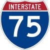 Interstate 75 is the southwest-to-northeast interstate highway in the county, which enters from Alachua County at bridges over the Santa Fe River. It has four interchanges in the county with US 41/441 in Ellisville (Exit 414), SR 47 (Exit 423), US 90 in Lake City (Exit 427) and I-10 in Springville (Exits 435 A-B).
 US 27 is another southeast-to-northwest road in southwestern Columbia County, that entets from a bridge over the Santa Fe River, runs through Fort White, and leaves at another bridge over the Ichetucknee River at Ichetucknee Springs State Park.
 US 41 runs north from High Springs in a concurrency with US 441 until just before it reaches Lake City, Then the two routes run parallel to each other until US 41 branches off to the northwest on its way to Hamilton County, Valdosta, Georgia, and points north.
 US 90 was the main west-to-east highway in the county, until it was surpassed by I-10. It enters the county from Wellborn in Suwannee County, and directly enters Lake City. East of the city, it runs along the southern edge of Osceola National Forest and serves as the address of two major prisons before crossing the Baker County Line and entering a portion of the forest itself.
 US 441 runs north from High Springs in a concurrency with US 41 until just before it reaches Lake City, Then the two routes run parallel to each other, but unlike US 41, US 441 stays in Columbia County and runs straight north and south until it crosses the Georgia State Line.
 State Road 2 is located on the far northeast corner of the county, and has no intersections whatsoever.
 State Road 47 is a northeast-to-southwest road that spans from Trenton in Gilchrist County to US 41 in Lake City. North of there it becomes a hidden state road along US 41 until it reaches US Truck Route 90, then turns east, only to turn north again onto US 441 where it remains for the duration until it crosses the Florida-Georgia State Line.
 State Road 100
 State Road 238
 State Road 247 is a northeast to southwest road that spans from Branford in Suwannee County, and terminates at US 90 in western Lake City, just east of US 90's interchange with I-75.
Railroads
Columbia County has at least three existing railroad lines. The primary one is a CSX line formerly owned by the Seaboard Air Line Railroad that served Amtrak's Sunset Limited until it was truncated to New Orleans in 2005 by Hurricane Katrina. Lake City (Amtrak station) was Columbia County's only active railroad station until that point. Another one is owned by the Georgia Southern and Florida Railway, and runs along US 41 from Lake City through Hamilton County. A third line runs along SR 100 into Union County.
Communities
City
Town
Unincorporated communities
- Columbia City
- Five Points
- Lulu
- Mikesville
- Newco
- Watertown
See also
References
- 1 2 "State & County QuickFacts". United States Census Bureau. Retrieved June 13, 2014.
- ↑ "Find a County". National Association of Counties. Archived from the original on 2011-05-31. Retrieved 2011-06-07.
- ↑ Publications of the Florida Historical Society. Florida Historical Society. 1908. p. 30.
- ↑ In 1958, the Columbia Amateur Radio Society was formed.
- ↑ "US Gazetteer files: 2010, 2000, and 1990". United States Census Bureau. 2011-02-12. Retrieved 2011-04-23.
- ↑ "County Totals Dataset: Population, Population Change and Estimated Components of Population Change: April 1, 2010 to July 1, 2015". Retrieved July 2, 2016.
- ↑ "U.S. Decennial Census". United States Census Bureau. Archived from the original on May 11, 2015. Retrieved June 13, 2014.
- ↑ "Historical Census Browser". University of Virginia Library. Retrieved June 13, 2014.
- ↑ "Population of Counties by Decennial Census: 1900 to 1990". United States Census Bureau. Retrieved June 13, 2014.
- ↑ "Census 2000 PHC-T-4. Ranking Tables for Counties: 1990 and 2000" (PDF). United States Census Bureau. Retrieved June 13, 2014.
- ↑ "American FactFinder". United States Census Bureau. Archived from the original on 2013-09-11. Retrieved 2011-05-14.
- ↑ http://dos.myflorida.com/elections/data-statistics/voter-registration-statistics/voter-registration-monthly-reports/voter-registration-current-by-county/
External links
| Wikimedia Commons has media related to Columbia County, Florida. |
Government links/Constitutional offices
- Columbia County Government / Board of County Commissioners
- Columbia County Supervisor of Elections
- Columbia County Property Appraiser
- Columbia County Tax Collector
- Columbia County Sheriff's Office
- Columbia County Tourism
Special districts
- Columbia County Public Schools
- Columbia County Public Libraries
- Suwannee River Florida Water Management District
- Columbia Amateur Radio Society since 1958
Judicial branch
- Columbia County Clerk of Courts
- Public Defender, 3rd Judicial Circuit of Florida serving Columbia, Dixie, Hamilton, Lafayette, Madison, Suwannee, and Taylor Counties
- Office of the State Attorney, 3rd Judicial Circuit of Florida
- Circuit and County Court, 3rd Judicial Circuit of Florida
Tourism links
- Lake City Weather dot Com Get LIVE Weather Reports here.
- Columbia County Tourism Development Council
- Suwannee Online
 |
Hamilton County | Echols County, Georgia | Clinch County, Georgia | |
| Suwannee County | |
Baker County | ||
| ||||
| | ||||
| Gilchrist County | Alachua County | Union County |
Municipalities and communities of Columbia County, Florida, United States | ||
|---|---|---|
| City | | |
| Town | ||
| CDPs | ||
| Unincorporated communities | ||
Coordinates: 30°14′N 82°38′W / 30.23°N 82.63°W