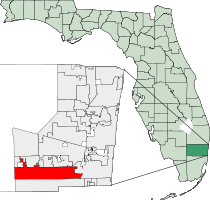
Pembroke Pines, Florida
| City of Pembroke Pines | ||
|---|---|---|
| City | ||
| ||
| Motto: "Join Us - Progress with Us" | ||
 | ||
| Coordinates: 26°0′45″N 80°18′49″W / 26.01250°N 80.31361°WCoordinates: 26°0′45″N 80°18′49″W / 26.01250°N 80.31361°W | ||
| Country |
| |
| State |
| |
| County |
| |
| Unofficially incorporated (village) | March 2, 1959[1] | |
| Incorporated (village) | January 16, 1960 | |
| Incorporated (city) | May 22, 1961 | |
| Government | ||
| • Type | Commission-Manager | |
| • Mayor | Frank C. Ortis (D)[2] | |
| • Vice Mayor | Iris A. Siple | |
| • Commissioners | Angelo Castillo, Carl Schecter, and Jay Schwartz | |
| • City Manager | Charles F. Dodge | |
| • City Clerk | Marlene Graham | |
| Area | ||
| • Total | 34.8 sq mi (90.2 km2) | |
| • Land | 33.1 sq mi (85.8 km2) | |
| • Water | 1.7 sq mi (4.4 km2) 4.88% | |
| Elevation | 7 ft (2 m) | |
| Population (2010)[3] | ||
| • Total | 154,750 | |
| • Estimate (2013)[4] | 162,329 | |
| • Density | 4,671.9/sq mi (1,803.8/km2) | |
| Time zone | Eastern (EST) (UTC-5) | |
| • Summer (DST) | EDT (UTC-4) | |
| ZIP codes | 33023-33029, 33330-33332 | |
| Area code(s) | 954, 754 | |
| FIPS code | 12-55775 | |
| GNIS feature ID | 0288686[5] | |
| Website | City of Pembroke Pines | |
Pembroke Pines is a city in Broward County, Florida, United States. The city had a population of 154,750 at the 2010 census,[6] making it the second-most populous city in Broward County and the 11th-most populous in Florida. It is a principal city of the Miami metropolitan area, which was home to an estimated 6,012,331 people at the 2015 census. Its official motto is "Join Us - Progress With Us."
History
Pembroke Pines was officially incorporated on January 16, 1960. The city's name, Pembroke Pines, is traced back to Sir Edward Reed, a Member of Britain's Parliament for the County of Pembroke in 1874, who purchased and farmed land in the 1880s which today occupies much of what is now the nearby city of Dania Beach. The road put through his land came to be known as Pembroke Road. When incorporating, the mayor (Dr. Kipnis) suggested the name Pembroke Pines because of the pine trees growing near Pembroke Road.
The first inhabitants of the area were American Indians who first appeared about 4,000 years ago. Skeletal remains of animal hunters dating back about 10,000 years were found around Broward County, showing that perhaps human beings had lived in the area even earlier.
The town started as agricultural land occupied by dairy farms and grew after World War II as servicemen were retiring, including large eastern sections that were part of the Waldrep Dairy Farm. The first two subdivisions were called Pembroke Pines. One of the first homes in the city belonged to Dr. and Mrs. Walter Smith Kipnis, built in 1956. Dr. Kipnis was also the first mayor. It was then known as the "Village of Pembroke Pines" and was incorporated into a village in 1959. Builders contested the incorporation, so a legal battle ensued concerning the boundaries of the new municipality. City services were added in the 1960s with the building of the first fire department building near North Perry Airport. However, University Drive was the western edge of habitable land for residents.
In January 1960, Pembroke Pines held another election, and the village became a city. This small property was less than a square mile and was between Hollywood Boulevard and SW 72nd Avenue, and had the Florida Turnpike to the east. Pembroke Pines sought to give citizens involvement so they organized the Pembroke Pines Civic Association. The square-mile city was unable to expand due to North Perry Airport and the South Florida State Hospital. Joseph LaCroix, a developer, had his 320 acres (1.3 km2) of land north of Pines Boulevard annexed to the city. This gave a new pathway to proceed westward. In 1977, a maximum security prison known as the Broward Correctional Institution was built in the northwestern part of town. This facility closed in 2012.[7] In 1980, property from Flamingo Road to U.S. 27 was incorporated into Pembroke Pines, doubling the size of the city. This expansion included the property that is currently C.B. Smith Park as well as what was once the Hollywood Sportatorium and the Miami-Hollywood Motorsports Park. At this time, I-75 was extended through the city.
The city's rapid population growth in the mid- to late 1990s was part of the effect of Hurricane Andrew in 1992. Thousands of southern Miami-Dade County residents moved northward to Broward County, many to Pembroke Pines. The resulting boom ranked the City of Pembroke Pines third in a list of "Fastest Growing Cities" in the United States in 1999.[8] Over the years, the increase in population has caused the need for schools. In 2003, Charles W. Flanagan High School had close to 6,000 students, making it the most populated high school in Florida. In response to Broward County's need to keep up with demands, Mayor Alex Fekete and City Manager Charles Dodge started a Charter School System. As of 2006, Pembroke Pines had the largest Charter School System in the county. The city is also home to campuses for Broward Community College and Florida International University. The city's population has grown from 65,452 in 1990 to 157,594 in 2011.[9]
In 2001, Pembroke Pines was home to the most dangerous road intersection (Pines Boulevard and Flamingo Road) in the United States, according to State Farm Insurance.[10] A bond initiative was passed by city residents to allow the city to begin construction to redesign the intersection. The intersection has since been expanded with additional east/west Pines Boulevard lanes.[11]
Over the past decade as developers expanded Pembroke Pines westward, more hurricanes have affected the city and its residents. In 1999 Hurricane Irene dumped up to 16 inches (410 mm) of rain in the city. The western communities, such as Chapel Trail and Silver Lakes, saw an estimated 19 inches (480 mm). Then in 2004, Hurricane Frances and Jeanne passed to the north (Palm Beach County) but brought tropical storm-force winds and left minor tree and shrub damage. The 2005 hurricane season left a mark on the city. Hurricane Katrina passed directly over the city as a category one storm. In its wake, it left some damage such as downed power lines and trees, especially in the Chapel Trail and Silver Lakes developments. In late October Hurricane Wilma's eye passed about 20 miles (32 km) toward the north of the city, which saw the strongest winds its residents had experienced in decades. The strongest wind officially recorded in the city was a 92-mile-per-hour (148 km/h) sustained wind, with a 101-mile-per-hour (163 km/h) wind gust. Most of the city was left without power for days, lights at intersections had been destroyed, a riot at a gas station which led to it being closed, most landscaping was destroyed or damaged beyond repair, and left minor structural damage (mainly roof and screen damage). In addition, schools remained closed for two weeks.
Geography
Pembroke Pines is located at 26°00′46″N 80°18′49″W / 26.012913°N 80.313689°W.[12]
According to the United States Census Bureau, the city has a total area of 34.8 square miles (90.2 km2), of which 33.1 square miles (85.8 km2) is land and 1.7 square miles (4.4 km2) (4.88%) is water, making it one of the largest cities in Broward County.[6]
Climate
Pembroke Pines has warm, dry winters and hot, muggy summers.
| Climate data for Pembroke Pines, FL | |||||||||||||
|---|---|---|---|---|---|---|---|---|---|---|---|---|---|
| Month | Jan | Feb | Mar | Apr | May | Jun | Jul | Aug | Sep | Oct | Nov | Dec | Year |
| Average high °F (°C) | 75 (24) |
77 (25) |
79 (26) |
82 (28) |
86 (30) |
89 (32) |
90 (32) |
90 (32) |
89 (32) |
86 (30) |
81 (27) |
77 (25) |
83.4 (28.6) |
| Average low °F (°C) | 57 (14) |
59 (15) |
62 (17) |
66 (19) |
71 (22) |
75 (24) |
75 (24) |
76 (24) |
75 (24) |
72 (22) |
66 (19) |
60 (16) |
67.8 (20) |
| Average precipitation inches (mm) | 2.62 (66.5) |
3.36 (85.3) |
3.58 (90.9) |
3.52 (89.4) |
6.20 (157.5) |
9.81 (249.2) |
7.41 (188.2) |
8.00 (203.2) |
9.45 (240) |
6.40 (162.6) |
3.90 (99.1) |
2.39 (60.7) |
66.64 (1,692.6) |
| Source: [13] | |||||||||||||
Surrounding areas
- Southwest Ranches, Davie, Cooper City, Hollywood
- The Everglades


 Hollywood
 - The Everglades

 Hollywood
 - The Everglades


 Hollywood
 - Miramar
The area of Pembroke Pines west of Flamingo Road is commonly known as West Pines, and consists mostly of subdivisions built since Hurricane Andrew.
Education
Broward County Public Schools serves Pembroke Pines. In addition, several charter schools are located in Pembroke Pines, and the City of Pembroke Pines operates its own charter school system.
Public high schools
- Charles W. Flanagan High School
- Pembroke Pines Charter High School
- West Broward High School
- McArthur High School (located in Hollywood, Florida)
- Somerset Academy Charter High School
- Everglades High School (located in Miramar, FL)
Public middle schools
- Franklin Academy Charter School [K-8]
- Glades Middle School (located in Miramar, Florida)
- Pembroke Pines Charter Middle School (Central and West)
- Pines Middle School
- Silver Trail Middle School
- Somerset Academy Charter Middle School
- Walter C. Young Middle School
Public elementary schools
- Chapel Trail Elementary School
- Franklin Academy Charter School [K-8]
- Lakeside Elementary School
- Palm Cove Elementary School
- Panther Run Elementary School
- Pasadena Lakes Elementary School
- Pembroke Lakes Elementary School
- Pembroke Pines Charter Elementary School (East, Central, West, and FSU campus)
- Pembroke Pines Elementary School
- Pines Lakes Elementary School
- Silver Palms Elementary School
- Silver Lakes Elementary School (located in Miramar, Florida)
- Somerset Academy Charter Elementary School
- Sunset Lakes Elementary School (located in Miramar, Florida)
- Greentree Preparatory Charter School
Higher education
- Florida Career College Pembroke Pines Campus
- The Broward-Pines Center regional campus of Barry University.
- The Broward-Pines Center regional campus of Broward College.
- The Broward-Pines Center regional campus of Florida International University.
- The South regional campus of Broward College
- Keiser University Pembroke Pines Campus.
Demographics
| Historical population | |||
|---|---|---|---|
| Census | Pop. | %± | |
| 1960 | 1,429 | — | |
| 1970 | 15,496 | 984.4% | |
| 1980 | 35,776 | 130.9% | |
| 1990 | 65,452 | 82.9% | |
| 2000 | 137,427 | 110.0% | |
| 2010 | 154,750 | 12.6% | |
| Est. 2015 | 166,611 | [14] | 7.7% |
| Pembroke Pines Demographics | |||
|---|---|---|---|
| 2010 Census | Pembroke Pines | Broward County | Florida |
| Total population | 154,750 | 1,748,066 | 18,801,310 |
| Population, percent change, 2000 to 2010 | +12.6% | +7.7% | +17.6% |
| Population density | 4,671.9/sq mi | 1,444.9/sq mi | 350.6/sq mi |
| White or Caucasian (including White Hispanic) | 67.3% | 63.1% | 75.0% |
| (Non-Hispanic White or Caucasian) | 32.9% | 43.5% | 57.9% |
| Black or African-American | 19.8% | 26.7% | 16.0% |
| Hispanic or Latino (of any race) | 41.4% | 25.1% | 22.5% |
| Asian | 4.9% | 3.2% | 2.4% |
| Native American or Native Alaskan | 0.3% | 0.3% | 0.4% |
| Pacific Islander or Native Hawaiian | 0.0% | 0.1% | 0.1% |
| Two or more races (Multiracial) | 3.3% | 2.9% | 2.5% |
| Some Other Race | 4.4% | 3.7% | 3.6% |
As of 2010, there were 61,703 households, with 7.8% of them being vacant. In 2000, 36.2% had children under the age of 18 living with them, 56.4% were married couples living together, 11.1% had a female householder with no husband present, and 29.1% were non-families. 24.1% of all households were made up of individuals and 12.5% had someone living alone who was 65 years of age or older. The average household size was 2.62 and the average family size was 3.13.
In 2000, the city the population was spread out with 25.6% under the age of 18, 6.4% from 18 to 24, 33.5% from 25 to 44, 19.3% from 45 to 64, and 15.2% who were 65 years of age or older. The median age was 36 years. For every 100 females there were 87.3 males. For every 100 females age 18 and over, there were 81.8 males.
In 2000, the median income for a household in the city was $52,629, and the median income for a family was $61,480. Males had a median income of $45,129 versus $32,531 for females. The per capita income for the city was $23,843. About 3.9% of families and 5.4% of the population were below the poverty line, including 5.2% of those under age 18 and 8.1% of those age 65 or over.
As of 2000, speakers of English as a first language were at 63.06%, while Spanish accounted for 27.91%, French made up 1.24%, French Creole comprised 0.99%, Portuguese was 0.94%, Italian was at 0.92%, Yiddish at 0.74%, and Tagalog was the mother tongue of 0.52% of the population.[16]
As of 2000, Pembroke Pines had the forty-fifth-highest percentage of Colombian residents in the US, at 3% of the city's population,[17] and the fiftieth-highest percentage of Cuban residents in the US, at 8.66% of the city's population.[18] It also had the twenty-fourth-highest percentage of Jamaicans in the US (tied with Wheatley Heights, New York,) at 5.1% of all residents.[19]
Notable people
- Eric Alejandro, olympian
- Angelia Alvarez, Contest on American's Next Top Model
- Kenny Anderson, former NBA player (current resident)
- Alex Avila, Major League Baseball player for the Detroit Tigers (former resident)
- Ethan Bortnick, pianist, singer, composer, songwriter, actor, musician and one of the youngest philanthropists in the world
- Conceited, Rapper and Cast member on Wild 'n Out
- Danny Farquhar, Major League Baseball player for the Tampa Bay Rays (former resident)
- Jeff Fiorentino, Major League Baseball player for the Baltimore Orioles (former resident)
- Frank Gore, professional football player for the Indianapolis Colts
- Shayne Gostisbehere, defenseman for Philadelphia Flyers
- DJ Khaled, 99 Jamz Radio DJ (current resident)
- Brandon Marinez, aka Concrete Zebra, aka B. Martini, aka Sentech Area Foreman. Music Producer, YouTube tutorial master (Craftmasters Production) spiritual guru
- Mike Napoli, Major League Baseball player who plays for the Cleveland Indians (current resident)
- Kendall Newson, former wide receiver for the Miami Dolphins (current resident)
- Manny Ramírez, Retired Major League Baseball player (current resident)
- Riley Reid, porn star
- Juan Sebastián Restrepo, Army medic killed in Afghanistan; lived here from 1999–2006
- Rick Ross, rapper
- Lawrence Taylor, former NFL star of the New York Giants (current resident)
- Niki Taylor, model
- Bella Thorne, actress and model
- Trina, rapper
- Walter C. Young, Florida businessman and legislator
References
- ↑ "Broward-by-the-Numbers (pages 3-5)" (PDF). www.broward.org. Retrieved 2015-02-15.
- ↑ "Frank Ortis's file". PolitiFact.com. Retrieved 12 April 2016.
Democrat from Florida
- ↑ "American FactFinder". United States Census Bureau. Retrieved 2014-08-01.
- ↑ "Population Estimates". United States Census Bureau. Retrieved 2014-08-01.
- ↑ "US Board on Geographic Names". United States Geological Survey. 2007-10-25. Retrieved 2008-01-31.
- 1 2 "Geographic Identifiers: 2010 Demographic Profile Data (G001): Pembroke Pines city, Florida; revised Jan. 14, 2013". U.S. Census Bureau, American Factfinder. Retrieved October 22, 2013.
- ↑ "Prison closings are a mixed bag, but mostly good". Highlands Today (Media General Communications Holdings, LLC.). 2012-01-16. Retrieved 2012-08-24.
- ↑ "Topic Galleries - South Florida". Sun-sentinel.com. Retrieved 2013-04-12.
- ↑ https://www.google.com/publicdata/explore?ds=kf7tgg1uo9ude_&met_y=population&idim=place:1255775&dl=en&hl=en&q=pembroke%20pines%20population%20statistics
- ↑ South Florida Intersection Tops Most Dangerous List - Miami News Story - WPLG Miami Archived September 26, 2011, at the Wayback Machine.
- ↑ "Is A Broward Intersection Still The Worst In The Nation?". CBS Miami. Retrieved October 8, 2016.
- ↑ "US Gazetteer files: 2010, 2000, and 1990". United States Census Bureau. 2011-02-12. Retrieved 2011-04-23.
- ↑ "Monthly Averages for Pembroke Pines, FL (33028)". Weather.com. Retrieved May 13, 2012.
- ↑ "Annual Estimates of the Resident Population for Incorporated Places: April 1, 2010 to July 1, 2015". Retrieved July 2, 2016.
- ↑ "Census of Population and Housing". Census.gov. Retrieved June 4, 2015.
- ↑ "MLA's Data Center Results for Pembroke Pines, Florida". Modern Language Association. Retrieved 2007-10-25.
- ↑ "Ancestry Map of Colombian Communities". Epodunk.com. Retrieved 2007-10-25.
- ↑ "Ancestry Map of Cuban Communities". Epodunk.com. Retrieved 2007-10-25.
- ↑ "Ancestry Map of Jamaican Communities". Epodunk.com. Retrieved 2007-10-25.
External links
-
 Media related to Pembroke Pines, Florida at Wikimedia Commons
 -
 Geographic data related to Pembroke Pines, Florida at OpenStreetMap
 - City of Pembroke Pines official website
- PINES CAM - Live webcam from Pembroke Pines, Florida
- "Pembroke Pines R&R Veterans Village" YouTube link to City of Pembroke Pines R&R Veterans Village.
Municipalities and communities of Broward County, Florida, United States | ||
|---|---|---|
| Cities | 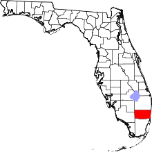 | |
| Towns | ||
| Villages | ||
| CDPs | ||
| Unincorporated community | ||
| Indian reservations | ||
| Ghost town | ||
| ||
| ||