Leyland, Lancashire
| Leyland | |
| — Town — | |
 Leyland |
|
| Population | 35,578 [1] (2001 census) |
|---|---|
| OS grid reference | SD549232 |
| District | South Ribble |
| Shire county | Lancashire |
| Region | North West |
| Country | England |
| Sovereign state | United Kingdom |
| Post town | LEYLAND |
| Postcode district | PR25, PR26 |
| Dialling code | 01772 |
| Police | Lancashire |
| Fire | Lancashire |
| Ambulance | North West |
| EU Parliament | North West England |
| UK Parliament | South Ribble |
|
|
Coordinates: 53°41′31″N 2°41′49″W / 53.692°N 2.697°W
Leyland is a town in the South Ribble district, in the county of Lancashire, England. It is approximately six miles (10 km) south of the city of Preston. The population of the town was estimated as 35,600 at the 2011 Census.
Throughout the 20th and 21st century, the community has seen a large growth in industry, population and farming, due to the establishment of Leyland Motors, housing developments and the surrounding usable arable land.
The name of the town is of old Anglo-Saxon origin, meaning "untilled land".
History
English Leyland was an area of fields, with Roman roads passing through, from ancient Wigan to Walton-le-Dale.
It was left undisturbed for many centuries until rediscovered shortly after the Battle of Hastings (1066). Leyland is mentioned in the Domesday Book (1085). In 1066 King Edward the Confessor presided over the whole of Leyland. The manor was divided into three large ploughlands, which were controlled by local noblemen. In the 12th century, it came under the barony of Penwortham.
The area of Worden, which is now Worden Park, was one of nine oxgangs of land granted to the Knights Hospitaller, by Roger de Lacy, in Lancashire, but the land was not assigned to any individual and a local man, who was a very close friend of de Lacy, Hugh Bussel, was assigned holder of the land in 1212.
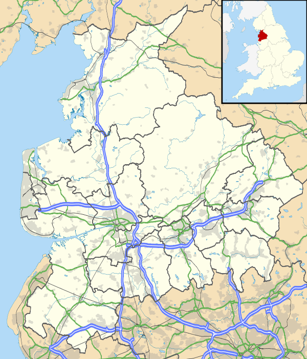
Notable features that remain include the St Andrew's Parish Church, built around 1200 AD and the large stone Leyland Cross, thought to date back to Saxon times.
Industry
The town is famous primarily for the bus and truck manufacturer Leyland Motors, which between the 1950s and 1970s expanded and grew to own several British motor manufacturers, including BMC, Standard-Triumph and Rover, culminating in the massive British Leyland company. The truck business still operates today as Leyland Trucks, and is owned by Paccar.
Leyland is also home to one of the UK's leading maintenance and utility companies, Enterprise Plc on Centurion Way. The Leyprint company is situated on Leyland Lane, a company which produces menus and other printed items.
A large Tesco superstore was built in 2002, and it stands near the police station. The old BTR Factory was knocked down to make way for new housing in 2004 and in 2006, the town was installed with a Morrisons, a Homebase (which closed down in 2014 and was replaced with The Range) and an Argos store.
The Leyland Band have also recently moved to the town, after several years in various other rehearsal locations, and now have a permanent home in Farington Business Park.
Transport
Leyland railway station is on the West Coast Main Line, the very placement of which moved the civic centre of the town briefly, including Leyland Police Station.
There is a marker adjacent to the old Leyland Motors Spurrier works declares the halfway point on the railway journey between Glasgow and London, some 198 miles in either direction.
John Fishwick & Son served the town's public transport needs. They also connected the town to Chorley and Preston. The company ceased trading on 24 October 2015 and Stagecoach Merseyside and South Lancashire have taken over their core route 111.[2]
Education
High schools
High schools in Leyland are Balshaw's CE High School near Leyland Cross, Leyland St Mary's Catholic High School, Academy@Worden, a smaller high school situated to the west of the town, and Wellfield High School near the town centre.[3]
Colleges
To the east of Worden Park is Runshaw College. The college received the best Ofsted report, for any further education college in the UK, for the year of 2005.
Architecture
Most of the housing in Leyland falls under the semi-detached, detached and bungalow categories. There are a few modern housing estates, but about 65% of the accommodation in the town was built in the 1970s.
Areas
Leyland is made up by six different areas, the town centre itself counts as the main retail side, with the railway station, library and shops nearby. The other areas include Broadfield, Moss Side, Worden Park, Turpin Green and the Wade Hall estate.
Geography
 |
Whitestake | Farington | Cuerden | |
| Midge Hall | |
Clayton-le-Woods | ||
| ||||
| | ||||
| Ulnes Walton | Euxton | Whittle-le-Woods |
People
Notable people who have grown up or lived in Leyland include:
- Fred Beardsworth, footballer
- William Bennett, 1920s footballer
- Clarke Carlisle, footballer, was educated at Balshaw's CE High School
- Trevor Hemmings, multi-millionaire philanthropist spent his teenage years in Leyland
- Allen Hill, played in the first ever cricket Test
- Phil Jones, footballer
- Frank Moss, football manager and former player, known for his six-year contract with Arsenal
- Danny Mayor, footballer
- Mike Salmon, retired goalkeeper, who currently works as a football manager
- Kevin Simm, Liberty X singer grew up in the area and attended St Anne's Primary School and St Mary's High School
- Mark Strange, martial arts expert and film producer
- Chris Tuson, rugby league player
- John Woodcock, executed by the Stuarts in 1646, for his Catholicism
Gallery
 Leyland Cross
.jpg) Old Police Station
Old Police Station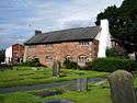 South Ribble Museum
 Balshaw's Grammar School
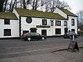 Eagle and Child pub
See also
- Listed buildings in Leyland, Lancashire
- Leyland Motors Ltd
- Leyland police station
- Leyland railway station
- Leyland Band
References
- ↑ Population of 35,578 is the sum of the following ward populations: Moss Side 3673; Earnshaw Bridge 3722; Golden Hill 3982; Seven Stars 3701; Lowerhouse 4050; Leyland St. Mary's 3562; Leyland Central 3626; Leyland St. Ambrose 3337; Leyland St. John's 5925. All accessed 30 September 2011.
- ↑ http://www.fishwicks.co.uk/
- ↑ GCSE success for Leyland students
- BBC Online (2006a) Schools in Lancashire, Education\League Tables, 19 January 2006 [accessed 27 June 2007]
- BBC Online (2006b) Institutions in Lancashire, Education\League Tables, 19 January 2006 [accessed 4 May 2007]
- Hunt, D., (1990), The History of Leyland and District, Carnegie Press, ISBN 0-948789-48-4
- Hunt, D. and Waring, W. (1995), The Archive Photograph Series: Leyland, Chalford Publishing Company, ISBN 0-7524-0348-6
- Smith, J., (2003), Then and Now: Leyland, Tempus Publishing, ISBN 0-7524-2672-9
- South Ribble Borough Council – Leyland Town Centre Masterplan [accessed 23 April 2008]
External links
| Wikimedia Commons has media related to Leyland, Lancashire. |
| Wikivoyage has a travel guide for Leyland. |
- Leyland Historical Society
- Leyland Round Table no.665
- South Ribble Borough Council
- Leyland Tennis Club
- Leyland Forum – A Community website
- Leyland Online – Community news and information
- Enterprise Plc
- The Leyland Project, Community support on the Wade Hall Estate