Ligonier, Indiana
| City of Ligonier | |
|---|---|
| City | |
|
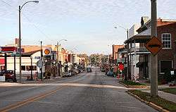
Downtown Ligonier. | |
| Motto: "City Of Murals" | |
 Location in the state of Indiana | |
| Coordinates: 41°27′51″N 85°35′29″W / 41.46417°N 85.59139°WCoordinates: 41°27′51″N 85°35′29″W / 41.46417°N 85.59139°W | |
| Country | United States |
| State | Indiana |
| County | Noble |
| Township | Perry |
| Government | |
| • Mayor | Patricia A. Fisel (R) |
| Area[1] | |
| • Total | 2.31 sq mi (5.98 km2) |
| • Land | 2.31 sq mi (5.98 km2) |
| • Water | 0 sq mi (0 km2) 0% |
| Elevation | 869 ft (265 m) |
| Population (2010)[2] | |
| • Total | 4,405 |
| • Estimate (2012[3]) | 4,388 |
| • Density | 1,906.9/sq mi (736.3/km2) |
| Time zone | EST (UTC-5) |
| • Summer (DST) | EDT (UTC-4) |
| ZIP code | 46767 |
| Area code(s) | 260 |
| FIPS code | 18-43686[4] |
| GNIS feature ID | 0437883[5] |
| Website | http://ligonier-in.org/ |
Ligonier is a city in Perry Township, Noble County, Indiana, United States. The population was 4,405 at the 2010 census.
History
Ligonier was platted in 1835.[6] The city was named for John Ligonier, a British army officer.[7]
The Ligonier Historical Museum is located in the 1889 building of the Ahavas Sholem Synagogue, one of the few surviving 19th-century synagogues in the United States.[8]
The Ahavas Shalom Reform Temple, Ligonier Historic District, and Jacob Straus House are listed on the National Register of Historic Places.[9]
Geography
Ligonier is located at 41°27′51″N 85°35′29″W / 41.46417°N 85.59139°W (41.464247, -85.591258).[10]
According to the 2010 census, Ligonier has a total area of 2.31 square miles (5.98 km2), all land.[1]
Demographics
| Historical population | |||
|---|---|---|---|
| Census | Pop. | %± | |
| 1870 | 1,514 | — | |
| 1880 | 2,010 | 32.8% | |
| 1890 | 2,195 | 9.2% | |
| 1900 | 2,231 | 1.6% | |
| 1910 | 2,173 | −2.6% | |
| 1920 | 2,037 | −6.3% | |
| 1930 | 2,064 | 1.3% | |
| 1940 | 2,178 | 5.5% | |
| 1950 | 2,375 | 9.0% | |
| 1960 | 2,595 | 9.3% | |
| 1970 | 3,034 | 16.9% | |
| 1980 | 3,134 | 3.3% | |
| 1990 | 3,443 | 9.9% | |
| 2000 | 4,357 | 26.5% | |
| 2010 | 4,405 | 1.1% | |
| Est. 2015 | 4,405 | [11] | 0.0% |

2010 census
As of the census[2] of 2010, there were 4,405 people, 1,333 households, and 978 families residing in the city. The population density was 1,906.9 inhabitants per square mile (736.3/km2). There were 1,550 housing units at an average density of 671.0 per square mile (259.1/km2). The racial makeup of the city was 69.6% White, 0.4% African American, 0.2% Native American, 0.5% Asian, 26.6% from other races, and 2.7% from two or more races. Hispanic or Latino of any race were 51.5% of the population.
There were 1,333 households of which 49.3% had children under the age of 18 living with them, 52.5% were married couples living together, 14.8% had a female householder with no husband present, 6.1% had a male householder with no wife present, and 26.6% were non-families. 22.1% of all households were made up of individuals and 8.4% had someone living alone who was 65 years of age or older. The average household size was 3.26 and the average family size was 3.83.
The median age in the city was 28.5 years. 34.7% of residents were under the age of 18; 9.6% were between the ages of 18 and 24; 28.3% were from 25 to 44; 19.5% were from 45 to 64; and 8% were 65 years of age or older. The gender makeup of the city was 49.8% male and 50.2% female.
2000 census
As of the census[4] of 2000, there were 4,357 people, 1,390 households, and 1,021 families residing in the city. The population density was 1,936.7 people per square mile (747.7/km²). There were 1,483 housing units at an average density of 659.2 per square mile (254.5/km²). The racial makeup of the city was 73.24% White, 0.53% African American, 0.16% Native American, 0.41% Asian, 24.70% from other races, and 0.96% from two or more races. Hispanic or Latino of any race were 33.30% of the population.
There were 1,390 households out of which 39.3% had children under the age of 18 living with them, 53.7% were married couples living together, 12.6% had a female householder with no husband present, and 26.5% were non-families. 21.4% of all households were made up of individuals and 9.6% had someone living alone who was 65 years of age or older. The average household size was 3.08 and the average family size was 3.52.
In the city the population was spread out with 31.4% under the age of 18, 13.0% from 18 to 24, 28.2% from 25 to 44, 17.2% from 45 to 64, and 10.3% who were 65 years of age or older. The median age was 28 years. For every 100 females there were 103.7 males. For every 100 females age 18 and over, there were 102.2 males.
The median income for a household in the city was $36,546, and the median income for a family was $42,757. Males had a median income of $31,596 versus $23,938 for females. The per capita income for the city was $14,448. About 7.5% of families and 14.3% of the population were below the poverty line, including 17.7% of those under age 18 and 6.0% of those age 65 or over.
Education
Ligonier is serviced by the West Noble School Corporation which maintains four schools at two locations in and around Ligonier.
West Noble Primary School serves students in Kindergarten & 1st Grade. It is located at 500 West Union Street.
West Noble Elementary School is located on the WNSC campus south of Ligonier on US-33. Grades 2-4 students who live outside Ligonier city limits attend WNES.
West Noble Middle School is located on the WNSC campus south of Ligonier on US-33. This building has grades 5-8.
West Noble High School is located on the WNSC campus south of Ligonier on US-33. All students grades 9-12 from Ligonier and the surrounding area attend this facility.
Newspaper
The Advance Leader, serving western Noble County, Ind., became part of KPC Media Group Inc. in May 1975. The weekly Cromwell Advance, founded in 1912 by Forrest Robbins, was purchased from Jim and Greta Wallace. The weekly Ligonier Leader, founded in 1880 by E.G. Thompson, was purchased from Norm Davis. The two mastheads were merged to form The Advance Leader, with the first issue published on May 14, 1975. The first co-editors were David Kurtz and Grace Witwer Housholder. The editor and general manager today is Robert Buttgen, who joined KPC in 1996.[13] The newspaper is published by KPC Media Group, with its website at kpcnews.com
Notable people
- Dwight H. Green, former Governor of Illinois
- Glen Steele, professional football player, attended West Noble High School, University of Michigan, NFL Cincinnati Bengals
- Douglas Rex, past president of American College of Gastroenterology
References
- 1 2 "G001 - Geographic Identifiers - 2010 Census Summary File 1". United States Census Bureau. Retrieved 2015-07-29.
- 1 2 "American FactFinder". United States Census Bureau. Retrieved 2012-12-11.
- ↑ "Population Estimates". United States Census Bureau. Retrieved 2013-06-25.
- 1 2 "American FactFinder". United States Census Bureau. Retrieved 2008-01-31.
- ↑ "US Board on Geographic Names". United States Geological Survey. 2007-10-25. Retrieved 2008-01-31.
- ↑ Goodspeed, Weston Arthur (1882). History of Whitley County. ill., ports. p. 145.
- ↑ Gannett, Henry (1905). The Origin of Certain Place Names in the United States. U.S. Government Printing Office. p. 186.
- ↑ Rediscovering Jewish Infrastructure: Update on United States Nineteenth Century Synagogues, Mark Gordon, American Jewish History 84.1 (1996) 20-27
- ↑ National Park Service (2010-07-09). "National Register Information System". National Register of Historic Places. National Park Service.
- ↑ "US Gazetteer files: 2010, 2000, and 1990". United States Census Bureau. 2011-02-12. Retrieved 2011-04-23.
- ↑ "Annual Estimates of the Resident Population for Incorporated Places: April 1, 2010 to July 1, 2015". Retrieved July 2, 2016.
- ↑ "Census of Population and Housing". Census.gov. Retrieved June 4, 2015.
- ↑ http://www.kpcnews.com/?x=about
External links
- City of Ligonier, Indiana website
- Noble County Convention and Visitors Bureau
- Operation Foundation Volunteer Project
Municipalities and communities of Noble County, Indiana, United States | ||
|---|---|---|
| Cities | ||
| Towns | ||
| Townships | ||
| CDP | ||
| Unincorporated communities |
| |
| Footnotes | ‡This populated place also has portions in an adjacent county or counties | |
| Counties | 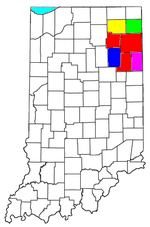 | |
|---|---|---|
| Municipalities with population over 10,000 in 2010 | ||
| Municipalities with population 1,000-10,000 in 2010 | ||
| Municipalities with population under 1,000 in 2010 | ||
| CDPs | ||