Lippitt Hill Historic District
|
Lippitt Hill Historic District | |
 | |
  | |
| Location | Cranston, Rhode Island |
|---|---|
| Coordinates | 41°44′23″N 71°32′6″W / 41.73972°N 71.53500°WCoordinates: 41°44′23″N 71°32′6″W / 41.73972°N 71.53500°W |
| Area | 140 acres (57 ha) |
| Architectural style | Greek Revival, Colonial, Federal |
| NRHP Reference # | 89000142 [1] |
| Added to NRHP | March 2, 1989 |
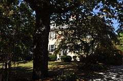
The Lippitt Hill Historic District is a historic district in Cranston, Rhode Island along Hope Road between Laten Knight Road and Hope Road's junction with Burlingame Road and Lippitt Avenue. This area was settled by Moses Lippitt, who in 1735 built a Georgian farmhouse for his son Christopher. Christopher later (1805) built a Federal style house for his son William. These two farmhouses are the anchors of this rural district, which also includes a historical cemetery in which many generations of Lippitts are buried, and which features a unique heart-shaped planting of pine trees.[2]
The district was added to the National Register of Historic Places in 1989.[1]
See also
References
- 1 2 National Park Service (2007-01-23). "National Register Information System". National Register of Historic Places. National Park Service.
- ↑ "NRHP nomination for Lippitt Hill Historic District" (PDF). Rhode Island Preservation. Retrieved 2014-08-01.
| Wikimedia Commons has media related to Lippitt Hill Historic District. |
| Topics | |
|---|---|
| Lists by states |
|
| Lists by insular areas | |
| Lists by associated states | |
| Other areas | |
| |
This article is issued from Wikipedia - version of the 11/26/2016. The text is available under the Creative Commons Attribution/Share Alike but additional terms may apply for the media files.