| Name |
Image |
Location |
Period |
UNESCO data |
Description |
Ref |
|---|
| Alto Douro Wine Region |
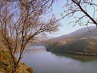 |
Douro Region
41°6′6″N 7°47′56″W / 41.10167°N 7.79889°W / 41.10167; -7.79889 (Alto Douro Wine Region) |
0000 !N/A |
2001 !1046; 2001; iii, iv, v; 24,600 ha (225,400 ha) |
| “ |
Wine has been produced by traditional landholders in the Alto Douro region for some 2,000 years. Since the 18th century, its main product, port wine, has been world famous for its quality. This long tradition of viticulture has produced a cultural landscape of outstanding beauty that reflects its technological, social and economic evolution. |
” |
|
[5] |
| Central Zone of the Town of Angra do Heroismo in the Azores |
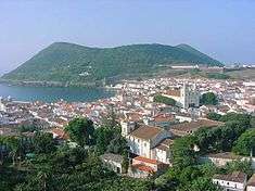 |
Terceira Island, Azores
38°39′18″N 27°13′12″W / 38.65500°N 27.22000°W / 38.65500; -27.22000 (Central Zone of the Town of Angra do Heroismo in the Azores) |
1500 !15th century |
1983 !206; 1983; iv, vi |
| “ |
Situated on one of the islands in the Azores archipelago, this was an obligatory port of call from the 15th century until the advent of the steamship in the 19th century. The 400-year-old San Sebastião and San João Baptista fortifications are unique examples of military architecture. Damaged by an earthquake in 1980, Angra is now being restored. |
” |
|
[6] |
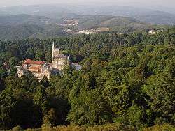
| Convent of Christ in Tomar |
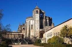 |
Tomar
39°36′17″N 8°25′3″W / 39.60472°N 8.41750°W / 39.60472; -8.41750 (Convent of Christ in Tomar) |
1200 !12th to 15th centuries |
1983 !265; 1983; i, vi |
| “ |
Originally designed as a monument symbolizing the Reconquest, the Convent of the Knights Templar of Tomar (transferred in 1344 to the Knights of the Order of Christ) came to symbolize just the opposite during the Manueline period – the opening up of Portugal to other civilizations. |
” |
|
[7] |
| Cultural Landscape of Sintra |
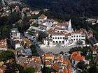 |
Sintra
38°47′0″N 9°25′0″W / 38.78333°N 9.41667°W / 38.78333; -9.41667 (Cultural Landscape of Sintra) |
1900 !19th century |
1995 !723; 1995; ii, iv, v; 946 ha (3,641 ha) |
| “ |
In the 19th century Sintra became the first centre of European Romantic architecture. Ferdinand II turned a ruined monastery into a castle where this new sensitivity was displayed in the use of Gothic, Egyptian, Moorish and Renaissance elements and in the creation of a park blending local and exotic species of trees. Other fine dwellings, built along the same lines in the surrounding serra , created a unique combination of parks and gardens which influenced the development of landscape architecture throughout Europe. |
” |
|
[8] |
| Garrison Border Town of Elvas and its Fortifications |
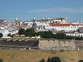 |
Elvas
38°52′50″N 7°9′48″W / 38.88056°N 7.16333°W / 38.88056; -7.16333 (Garrison Border Town of Elvas and its Fortifications) |
1700 !17th to 19th centuries |
2012 !1367; 2012; iv; 179 ha (608 ha) |
| “ |
The site, extensively fortified from the 17th to 19th centuries, represents the largest bulwarked dry-ditch system in the world. Within its walls, the town contains barracks and other military buildings as well as churches and monasteries. While Elvas contains remains dating back to the 10th century ad, its fortification began when Portugal regained independence in 1640. The fortifications designed by Dutch Jesuit padre Cosmander represent the best surviving example of the Dutch school of fortifications anywhere. The site also contains the Amoreira Aqueduct, built to enable the stronghold to withstand lengthy sieges. |
” |
|
[9] |
| Historic Centre of Évora |
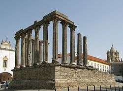 |
Évora
38°34′23″N 7°54′28″W / 38.57306°N 7.90778°W / 38.57306; -7.90778 (Historic Centre of Évora) |
0100 !1st to 18th centuries |
1986 !361; 1986; ii, iv |
| “ |
This museum-city, whose roots go back to Roman times, reached its golden age in the 15th century, when it became the residence of the Portuguese kings. Its unique quality stems from the whitewashed houses decorated with azulejos and wrought-iron balconies dating from the 16th to the 18th century. Its monuments had a profound influence on Portuguese architecture in Brazil. |
” |
|
[10] |
| Historic Centre of Guimarães |
 |
Guimarães, Minho Province
41°26′27″N 8°17′41″W / 41.44083°N 8.29472°W / 41.44083; -8.29472 (Historic Centre of Guimarães) |
1200 !12th to 19th centuries |
2001 !1031; 2001; ii, iii, iv; 16 ha (45 ha) |
| “ |
The historic town of Guimarães is associated with the emergence of the Portuguese national identity in the 12th century. An exceptionally well-preserved and authentic example of the evolution of a medieval settlement into a modern town, its rich building typology exemplifies the specific development of Portuguese architecture from the 15th to 19th century through the consistent use of traditional building materials and techniques. |
” |
|
[11] |
| Historic Centre of Oporto |
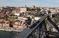 |
Porto
41°8′30″N 8°37′0″W / 41.14167°N 8.61667°W / 41.14167; -8.61667 (Historic Centre of Oporto) |
0800 !8th to 19th centuries |
1996 !755; 1996; iv |
| “ |
The city of Oporto, built along the hillsides overlooking the mouth of the Douro river, is an outstanding urban landscape with a 2,000-year history. Its continuous growth, linked to the sea (the Romans gave it the name Portus, or port), can be seen in the many and varied monuments, from the cathedral with its Romanesque choir, to the neoclassical Stock Exchange and the typically Portuguese Manueline-style Church of Santa Clara. |
” |
|
[12] |
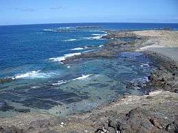
| Landscape of the Pico Island Vineyard Culture |
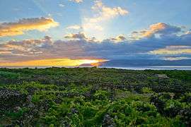 |
Pico Island, Azores
38°30′48″N 28°32′28″W / 38.51333°N 28.54111°W / 38.51333; -28.54111 (Landscape of the Pico Island Vineyard Culture) |
1500 !15th century |
2004 !1117; 2004; iii, v; 190 ha (2,445 ha) |
| “ |
The 987-ha site on the volcanic island of Pico, the second largest in the Azores archipelago, consists of a remarkable pattern of spaced-out, long linear walls running inland from, and parallel to, the rocky shore. The walls were built to protect the thousands of small, contiguous, rectangular plots (currais) from wind and seawater. Evidence of this viniculture, whose origins date back to the 15th century, is manifest in the extraordinary assembly of the fields, in houses and early 19th-century manor houses, in wine-cellars, churches and ports. The extraordinarily beautiful man-made landscape of the site is the best remaining area of a once much more widespread practice. |
” |
|
[13] |
| Laurisilva of Madeira |
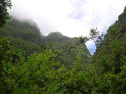 |
Madeira
32°46′0″N 17°0′0″W / 32.76667°N 17.00000°W / 32.76667; -17.00000 (Laurisilva of Madeira) |
0000 !N/A |
1999 !934; 1999; ix, x; 15,000 ha |
| “ |
The Laurisilva of Madeira is an outstanding relict of a previously widespread laurel forest type. It is the largest surviving area of laurel forest and is believed to be 90% primary forest. It contains a unique suite of plants and animals, including many endemic species such as the Madeiran long-toed pigeon. |
” |
|
[14] |
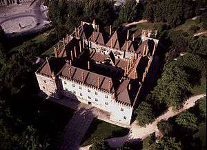
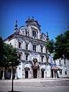
| Monastery of Alcobaça |
_2.jpg) |
Alcobaça
39°33′0″N 8°58′36″W / 39.55000°N 8.97667°W / 39.55000; -8.97667 (Monastery of Alcobaça) |
1200 !12th to 18th centuries |
1989 !505; 1989; i, iv |
| “ |
The Monastery of Santa Maria d'Alcobaça, north of Lisbon, was founded in the 12th century by King Alfonso I. Its size, the purity of its architectural style, the beauty of the materials and the care with which it was built make this a masterpiece of Cistercian Gothic art. |
” |
|
[15] |
| Monastery of Batalha |
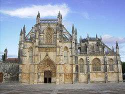 |
Batalha
39°39′28″N 8°49′37″W / 39.65778°N 8.82694°W / 39.65778; -8.82694 (Monastery of Batalha) |
1400 !14th century |
1983 !264; 1983; i, ii; 0.98 ha (86 ha) |
| “ |
The Monastery of the Dominicans of Batalha was built to commemorate the victory of the Portuguese over the Castilians at the battle of Aljubarrota in 1385. It was to be the Portuguese monarchy's main building project for the next two centuries. Here a highly original, national Gothic style evolved, profoundly influenced by Manueline art, as demonstrated by its masterpiece, the Royal Cloister. |
” |
|
[16] |
| Monastery of the Hieronymites and Tower of Belém in Lisbon |
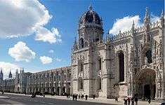
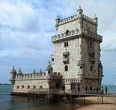 |
Lisbon
38°41′31″N 9°12′57″W / 38.69194°N 9.21583°W / 38.69194; -9.21583 (Monastery of the Hieronymites and Tower of Belém in Lisbon) |
1600 !16th to 17th centuries |
1983 !263; 1983, 2008 (extended);[nb 2] iii, iv; 2.66 ha (103 ha) |
| “ |
Standing at the entrance to Lisbon harbour, the Monastery of the Hieronymites – construction of which began in 1502 – exemplifies Portuguese art at its best. The nearby Tower of Belém, built to commemorate Vasco da Gama's expedition, is a reminder of the great maritime discoveries that laid the foundations of the modern world. |
” |
|
[17] |
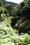
| Prehistoric Rock Art Sites in the Côa Valley and Siega Verde |
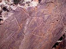 |
Douro Region (shared with Spain)
40°41′51″N 6°39′40″W / 40.69750°N 6.66111°W / 40.69750; -6.66111 (Prehistoric Rock Art Sites in the Côa Valley and Siega Verde) |
0001 !Paleolithic |
1998 !866; 1998, 2010 (extended);[nb 3] i, iii |
| “ |
The two Prehistoric Rock Art Sites in the Côa Valley (Portugal) and Siega Verde (Spain) are located on the banks of the rivers Agueda and Côa, tributaries of the river Douro, documenting continuous human occupation from the end of the Paleolithic Age. Hundreds of panels with thousands of animal figures (5,000 in Foz Côa and around 440 in Siega Verde) were carved over several millennia, representing the most remarkable open-air ensemble of Paleolithic art on the Iberian Peninsula. |
” |
|
[18] |
| University of Coimbra – Alta and Sofia |
.jpg) |
Coimbra
40°12′28.12″N 8°25′32.79″W / 40.2078111°N 8.4257750°W / 40.2078111; -8.4257750 (University of Coimbra – Alta and Sofia) |
1200 !12th to 20th centuries |
2013 !1387; 2013; ii, iii, iv, vi; 36 ha (82 ha) |
| “ |
Situated on a hill overlooking the city, the University of Coimbra with its colleges grew and evolved over more than seven centuries within the old town. (...) The University's edifices became a reference in the development of other institutions of higher education in the Portuguese-speaking world where it also exerted a major influence on learning and literature. Coimbra offers an outstanding example of an integrated university city with a specific urban typology as well as its own ceremonial and cultural traditions that have been kept alive through the ages. |
” |
|
[19] |
.jpg)


.jpg)