List of historic states of Italy
Part of a series on the |
|---|
| History of Italy |
 |
|
|
|
|
|
|
Italy after the dissolution of the Western Roman Empire in 476 and the successive barbarian invasions, up until the Italian unification in 1860, was a conglomeration of city-states, republics, and other independent entities. The following is a list of the various Italian states during that period.
Early Middle Ages
- Ostrogothic Kingdom
- Lombard Kingdom
- Exarchate of Ravenna (under the Byzantine Empire)
- Exarchate of Carthage (under the Byzantine Empire)
- Thema of Sicily (under the Byzantine Empire)
- Duchy of Benevento
- Papal States
- Kingdom of Italy (under the Carolingian Empire)
- Catepanate of Italy (under the Byzantine Empire)
High Middle Ages
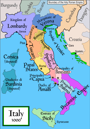
States of the Holy Roman Empire
- Kingdom of Italy (also called Kingdom of Lombardy)
- March of Tuscany
- March of Verona
- March of Treviso
- March of Ivrea
- March of Turin
- March of Montferrat
- March of Genoa
- Patriarchate of Aquileia (including March of Friuli and March of Istria)
- Duchy of Spoleto
- Bishopric of Brixen
- Bishopric of Trent
- County of Savoy
- County of Gorizia
- Marquisate of Saluzzo
- Marquisate of Ceva
- Marquisate of Incisa
- Marquisate of Finale
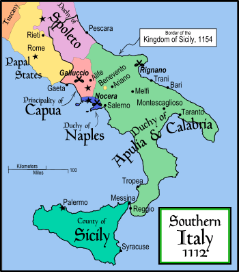
States in Southern Italy
- Catepanate of Italy (under the Byzantine Empire)
- Principality of Benevento
- Principality of Salerno
- Principality of Capua
- Duchy of Gaeta
- Duchy of Naples
- Duchy of Amalfi
- Duchy of Sorrento
- Emirate of Sicily (under the Fatimid Caliphate)
- County of Sicily
- County of Apulia
- Duchy of Apulia
- Duchy of Calabria
- Duchy of Apulia and Calabria
- Kingdom of Sicily
Giudicati of Sardinia
- Giudicato of Agugliastra
- Giudicato of Arborea
- Giudicato of Cagliari
- Giudicato of Gallura
- Giudicato of Logudoro
Other states
- Papal States
- Republic of Venice
- Republic of Genoa
- Republic of Pisa
- Republic of Florence
- Republic of Lucca
- Republic of Siena
- Republic of Ancona
- Republic of Noli
- Republic of Senarica
- Republic of Ragusa
- Republic of San Marino
Late Middle Ages
- Papal States
- Kingdom of Naples
- Kingdom of Sicily
- Kingdom of Sardinia and Corsica
- Duchy of Milan
- Duchy of Ferrara
- Duchy of Modena and Reggio
- Prince-Bishopric of Brixen
- Prince-Bishopric of Trent
- Marquisate of Saluzzo
- Marquisate of Montferrat
- Marquisate of Mantua
- Marquisate of Massa
- Marquisate of Finale
- Marquisate of Incisa
- Marquisate of Ceva
- Marquisate of Fosdinovo
- Marquisate of Bastia
- County of Savoy (raised to Duchy of Savoy in 1416)
- County of Urbino (raised to Duchy of Urbino in 1443)
- County of Mirandola
- County of Guastalla
- County of Nice (in personal union with Savoy)
- County of Gorizia
- County of Montechiarugolo
- County of Santa Fiora
- County of Asti
- County of Masserano
- County of Correggio
- County of Pitigliano
- County of Novellara
- County of Tende
- County of Sovana
- County of Scandiano
- Republic of Venice
- Republic of Genoa
- Republic of Lucca
- Republic of Florence
- Republic of Siena
- Republic of Ancona
- Republic of Noli
- Republic of Senarica
- Republic of Cospaia
- Republic of Ragusa
- Republic of San Marino
After the Italian Wars (1494–1559)
map from the Cambridge Modern History Atlas, 1912.
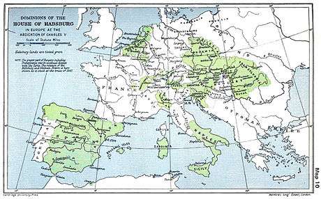
The Peace of Cateau-Cambrésis was signed between Elizabeth I of England and Henry II of France on 2 April and between Henry II and Philip II of Spain on 3 April 1559, at Le Cateau-Cambrésis. Under its terms, France restored Piedmont and Savoy to the Duke of Savoy, and Corsica to the Republic of Genoa. More importantly, the treaty confirmed Spanish direct control of Milan, Naples, Sicily, Sardinia, and the State of Presidi, and indirectly (through dominance of the rulers of Tuscany, Genoa, and other minor states) of northern Italy. The Pope was also their natural ally. The only truly independent entities on Italian soil were the Duchy of Savoy and the Republic of Venice.
- Papal States
- Kingdom of Naples (under Habsburg Spain)
- Kingdom of Sicily (under Habsburg Spain)
- Kingdom of Sardinia (under Habsburg Spain)
- Duchy of Savoy
- Duchy of Milan (under Habsburg Spain)
- Duchy of Mantua
- Duchy of Parma and Piacenza
- Duchy of Ferrara
- Duchy of Modena and Reggio (in personal union with Ferrara)
- Duchy of Florence (raised to Grand Duchy of Tuscany in 1569)
- Duchy of Urbino
- Duchy of Castro (in personal union with Parma)
- Prince-Bishopric of Brixen
- Prince-Bishopric of Trent
- Principality of Piombino
- Principality of Monaco
- Marquisate of Montferrat (raised to Duchy of Montferrat in 1574; in personal union with Mantua)
- Marquisate of Masserano (raised to Principality of Masserano in 1598)
- Marquisate of Sabbioneta (raised to Duchy of Sabbioneta in 1577)
- Marquisate of Finale
- Marquisate of Massa (raised to Principality of Massa in 1568)
- Marquisate of Carrara (in personal union with Massa)
- Marquisate of Castiglione (raised to Principality of Castiglione in 1609)
- Marquisate of Torriglia
- Marquisate of Fosdinovo
- Marquisate of Bastia
- County of Guastalla
- County of Mirandola
- County of Montechiarugolo
- County of Correggio (raised to Principality of Correggio in 1616)
- County of Novellara
- County of Pitigliano
- County of Tende
- County of Santa Fiora
- Republic of Venice
- Republic of Genoa
- Republic of Lucca
- Republic of Ragusa
- Republic of San Marino
- Republic of Noli
- Republic of Senarica
- Republic of Cospaia
- Malta (ruled by the Knights Hospitaller)
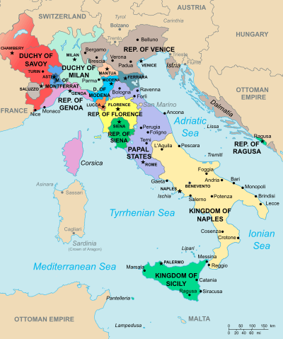
After the War of the Spanish Succession (1701–1714)
By the Treaty of Utrecht's provisions, the European empire of Spain was divided. In Italy, the Duchy of Savoy received Sicily and parts of the Duchy of Milan, while Charles VI (the Archduke of Austria) received the Kingdom of Naples, Sardinia, and the bulk of the Duchy of Milan along with other minor states.
- Papal States
- Kingdom of Naples (under Habsburg Monarchy up to 1734)
- Kingdom of Sicily (under Savoy from 1714 to 1720; under Habsburg Monarchy from 1720 to 1734; in personal union with Naples thereafter)
- Kingdom of Sardinia (under Habsburg Monarchy from 1714 to 1720; in personal union with Savoy thereafter)
- Grand Duchy of Tuscany
- Duchy of Savoy
- Duchy of Milan (under Habsburg Monarchy)
- Duchy of Mantua (under Habsburg Monarchy)
- Duchy of Parma and Piacenza (under Habsburg Monarchy from 1734 to 1748)
- Duchy of Guastalla (in personal union with Parma from 1748)
- Duchy of Modena and Reggio
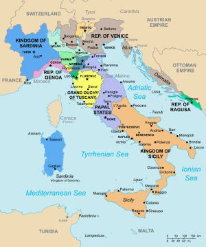 Political map of Italy in the year 1796.
 - Duchy of Massa and Carrara (in personal union with Modena from 1731)
- Duchy of Mirandola (in personal union with Modena from 1710)
- Prince-Bishopric of Brixen
- Prince-Bishopric of Trent
- Principality of Masserano
- Principality of Torriglia
- Principality of Piombino
- Principality of Monaco
- Marquisate of Fosdinovo
- Marquisate of Bastia
- Republic of Venice
- Republic of Genoa
- Republic of Lucca
- Republic of San Marino
- Republic of Ragusa
- Republic of Noli
- Republic of Senarica
- Republic of Cospaia
- Corsican Republic
- Malta (ruled by the Knights Hospitaller)
During Napoleonic times (1792–1815)
Sister republics of Revolutionary France
- Republic of Alba
- Republic of Bergamo
- Republic of Brescia
- Republic of Crema
- Republic of Pescara
- Piedmontese Republic
- Anconine Republic
- Cispadane Republic
- Transpadane Republic
- Cisalpine Republic
- Subalpine Republic
- Ligurian Republic
- Bolognese Republic
- Tiberina Republic
- Roman Republic
- Parthenopean Republic
- Italian Republic
Client states of the First French Empire
- Kingdom of Italy
- Kingdom of Etruria
- Kingdom of Naples
- Principality of Lucca and Piombino
- Principality of Benevento
- Principality of Pontecorvo
Other states
- Kingdom of Sardinia
- Kingdom of Sicily
- Anglo-Corsican Kingdom
- Principality of Elba (non-hereditary Monarchy under the exiled Emperor Napoleon)
- Republic of San Marino
- Republic of Cospaia
From the Restoration to the Unification
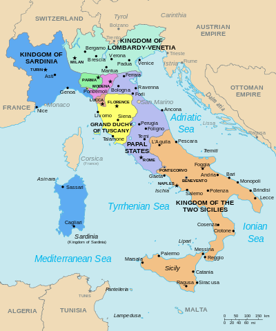
Following the defeat of Napoleonic France, the Congress of Vienna (1815) was convened to redraw the European continent. In Italy, the Congress restored the pre-Napoleonic patchwork of independent governments, either directly ruled or strongly influenced by the prevailing European powers, particularly Austria. The Congress also determined the end of two millenary republics: Genoa was annexed by Sardinia, and Venice was incorporated with Milan into a new kingdom of the Austrian Empire. At the time, the struggle for Italian unification was perceived to be waged primarily against the Habsburgs, since they directly controlled the predominantly Italian-speaking northeastern part of present-day Italy and were, together, the most powerful force against unification. The Austrian Empire vigorously repressed nationalist sentiment growing on the Italian peninsula, as well as in the other parts of Habsburg domains.
- Papal States
- Kingdom of Sardinia
- Kingdom of the Two Sicilies
- Kingdom of Lombardy–Venetia (under Austrian Empire)
- Kingdom of Illyria (under Austrian Empire)
- Grand Duchy of Tuscany
- Duchy of Parma, Piacenza and Guastalla
- Duchy of Modena and Reggio
- Duchy of Massa and Carrara
- Duchy of Lucca
- Principality of Monaco
- Republic of San Marino
- Republic of Cospaia
- Republic of San Marco
- Roman Republic
- United Provinces of Central Italy
See also
- Kingdom of Italy (1861–1946)
- List of former sovereign states
- List of historic states of Russia
- List of historic states of Germany
Italy articles | ||||||||
|---|---|---|---|---|---|---|---|---|
| History |
| | ||||||
| Geography | ||||||||
| Politics | ||||||||
| Economy | ||||||||
| Society |
| |||||||
| ||||||||