List of lighthouses in Oregon
This is a list of current and former lighthouses in Oregon.
Oregon Coast
This is a complete list of existing public and private lighthouses on the Oregon Coast, in order from north to south. Not all of them are currently used for navigation.
| Name | Image | Location | Height | Year lit | Year automated | Year deactivated | Description |
|---|---|---|---|---|---|---|---|
| Tillamook Rock Light |  |
Cannon Beach/Seaside 45°56′15″N 124°01′08″W / 45.9375°N 124.019°W |
62 ft (19 m) | 1881[1] | 1957[2] | Known as "Terrible Tillie" due to erratic weather conditions and the dangerous commute for keepers and suppliers.[2] Listed on the National Register of Historic Places (NRHP) in 1981.[3] | |
| Cape Meares Light | 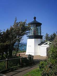 |
Oceanside/Tillamook 45°29′11.6″N 123°58′42.2″W / 45.486556°N 123.978389°W |
38 ft (12 m)[4] | 1890[5] | 1963[5] | Located at the south side of Tillamook Bay[6] and within a state park;[4] no old surrounding structures remain,[6] but the light still has its original lens;[4] listed on NRHP in 1993.[3] | |
| Yaquina Head Light | 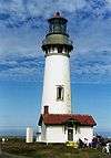 |
Newport 44°40′36.4″N 124°4′45.9″W / 44.676778°N 124.079417°W |
93 ft (28 m) | 1873[7] | 1966[7] | Located on a headland just north of Newport, listed on NRHP in 1993,[8] tallest lighthouse in Oregon [9] | |
| Yaquina Bay Light |  |
Newport 44°37′27″N 124°03′46″W / 44.62415°N 124.06290°W |
51 ft (16 m) | 1871–74, Reactivated 1996[5] | 1996 | Located at Yaquina Bay State Recreation Site south of Yaquina Head Light, deactivated in 1874 due to the new Yaquina Head Light,[10] added to NRHP in 1970,[3] re-lit in 1996 using a lens provided by lighthouse historian James A. Gibbs[11] | |
| Cleft of the Rock Light | 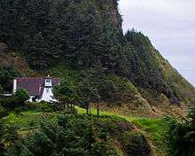 |
Yachats 44°17′26″N 124°06′39″W / 44.290479°N 124.110773°W |
34 ft (10 m) | 1976[12] | 1976 | Private aid to navigation, a wooden lighthouse about a mile south of Yachats built by James A. Gibbs in 1976, closed to the public[12][13] | |
| Heceta Head Light | 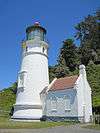 |
Florence 44°08′15″N 124°07′40″W / 44.13737°N 124.127835°W |
56 ft (17 m) | 1894[5] | 1963 | The brightest light on the Oregon Coast, visible 21 miles (34 km) out to sea, named for Spanish explorer Bruno de Heceta, added to NRHP in 1978, now part of a state park[14][15] | |
| Umpqua River Light | 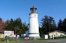 |
Winchester Bay 43°39′44″N 124°11′55″W / 43.662291°N 124.198476°W |
61 ft (19 m) | 1894 | 1966 | ||
| Cape Arago Light |  |
Coos Bay 43°20′28″N 124°22′32″W / 43.34123°N 124.37543°W |
44 ft (13 m) | 1934 | 1966 | 2006 | Added to NRHP list in 1993. |
| Coquille River Light |  |
Bandon 43°07′26″N 124°25′27″W / 43.123911°N 124.424222°W |
40 ft (12 m) | 1896 | 1939 | Added to NRHP list in 1974. | |
| Cape Blanco Light | 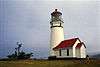 |
Port Orford 42°50′12″N 124°33′48″W / 42.8365897°N 124.5633023°W |
59 ft (18 m) | 1870 | 1980 | ||
| Port of Brookings Light[16] (Pelican Bay Light) |
Brookings 42°02′30″N 124°15′46″W / 42.04175°N 124.26279°W |
35 ft (11 m) | 1997 | 1997 | Private |
Former coastal lights
| Name | Location | Year lit | Year automated | Year deactivated | Year demolished | Description |
|---|---|---|---|---|---|---|
| Desdemona Sands Light | Astoria 46°13′31″N 123°57′13″W / 46.22528°N 123.95361°W |
1901 | 1934 | 1965 | 1965 | Located at the Columbia Bar; built on wooden pilings, rendered obsolete by the introduction of the Lightship Columbia |
| Point Adams Light | Astoria 46°11′18″N 123°58′40″W / 46.188333°N 123.977778°W |
1875 | 1899 | 1912 | Located at the Columbia Bar; rendered obsolete by south jetty extension, and subsequently burned to the ground | |
| United States lightship Columbia (WLV-604) | Moored offshore near the mouth of the Columbia | Commissioned 1951 | Decommissioned 1979 | Replaced by unmanned navigational buoy; now located at the Columbia River Maritime Museum in Astoria |
Current and former inland lights
| Name | Image | Location | Height | Year lit | Year automated | Year deactivated | Description |
|---|---|---|---|---|---|---|---|
| Warrior Rock Light |  |
On the Columbia River, on Sauvie Island near Portland 45°50′55″N 122°47′18″W / 45.84858°N 122.78835°W |
25 feet (7.6 m) | 1877 | 1930 | Oregon's smallest lighthouse and only current river lighthouse, if Umpqua River Light is considered to be on the coast. | |
| Willamette River Light | At the mouth of the Willamette River near the Columbia | 1895 | 1935 | Former lighthouse that burned in 1950s. | |||
See also
References
- ↑ Cowan, Ron (April 30, 2005). "Loud past, quiet future". Statesman Journal. Salem, Oregon. Retrieved November 11, 2014.
- 1 2 Yardley, William (October 24, 2007). "Terrible Tillie, Where the Departed Rest Not Quite in Peace". The New York Times. Retrieved November 11, 2014.
- 1 2 3 "Oregon National Register List" (PDF). Oregon Parks and Recreation Department. June 6, 2011. Retrieved November 11, 2014.
- 1 2 3 "Oregon Coast Lighthouses" (PDF). Oregon Parks and Recreation Department. p. 2. Retrieved January 2, 2015.
- 1 2 3 4 "Historic Light Station Information & Photography: Oregon". U.S. Coast Guard. Retrieved November 20, 2014.
- 1 2 "Cape Meares Light". Inventory of Historic Light Stations: Oregon Lighthouses. National Park Service, Maritime Heritage Program. March 6, 2002. Archived from the original on September 20, 2013.
- 1 2 "Yaquina Head Lighthouse". Bureau of Land Management. Retrieved November 11, 2014.
- ↑ "Yaquina Head Lighthouse (Newport, Oregon)". University of Oregon Libraries. Retrieved November 11, 2014.
- ↑ "Yaquina Head Outstanding Natural Area". Bureau of Land Management. Retrieved November 11, 2014.
- ↑ "Yaquina Bay Light (Old)". Inventory of Historic Light Stations: Oregon Lighthouses. National Park Service, Maritime Heritage Program. March 7, 2002. Archived from the original on September 20, 2013.
- ↑ "Yaquina Bay, OR". Lighthouse Friends. Retrieved November 22, 2014.
- 1 2 Young, Don; Young, Marjorie (2009). Adventure Guide to the Pacific Northwest. Edison, New Jersey: Hunter Publishing. p. 107. ISBN 1-58843-131-2.
- ↑ Engeman, Richard H. (2009). The Oregon Companion. Portland, Oregon: Timber Press. p. 222. ISBN 978-0-88192-899-0.
- ↑ "Heceta Head Lighthouse State Scenic Viewpoint". Oregon State Parks and Recreation Department. Retrieved December 7, 2014.
- ↑ "Heceta Head Lighthouse State Scenic Viewpoint: Park History". Oregon State Parks and Recreation Department. Retrieved December 7, 2014.
- ↑ "Oregon Almanac: Hydropower Projects to State Motto". Oregon Blue Book. Oregon Secretary of State. Retrieved November 20, 2014.
External links
| Wikimedia Commons has media related to Lighthouses in Oregon. |
- Illustrated map showing location, range, photos, height, visiting hours, etc.
This article is issued from Wikipedia - version of the 9/8/2016. The text is available under the Creative Commons Attribution/Share Alike but additional terms may apply for the media files.