Longton, Kansas
| Longton, Kansas | |
|---|---|
| City | |
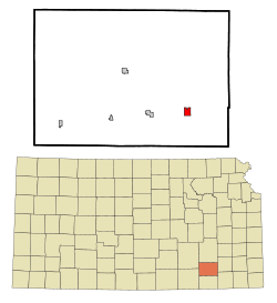 Location within Elk County and Kansas | |
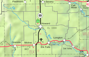 KDOT map of Elk County (legend) | |
| Coordinates: 37°22′39″N 96°4′58″W / 37.37750°N 96.08278°WCoordinates: 37°22′39″N 96°4′58″W / 37.37750°N 96.08278°W | |
| Country | United States |
| State | Kansas |
| County | Elk |
| Government | |
| • Type | Mayor–Council |
| Area[1] | |
| • Total | 1.16 sq mi (3.00 km2) |
| • Land | 1.15 sq mi (2.98 km2) |
| • Water | 0.01 sq mi (0.03 km2) |
| Elevation | 922 ft (281 m) |
| Population (2010)[2] | |
| • Total | 348 |
| • Estimate (2015)[3] | 311 |
| • Density | 300/sq mi (120/km2) |
| Time zone | CST (UTC-6) |
| • Summer (DST) | CDT (UTC-5) |
| ZIP code | 67352 |
| Area code | 620 |
| FIPS code | 20-42650 [4] |
| GNIS feature ID | 0469856 [5] |
| Website | City Website |
Longton is a city in Elk County, Kansas, United States, along the Elk River. As of the 2010 census, the city population was 348.[6]
History
Longton was founded in 1870.[7] It was named after Longton, in England.[8][9]
The first post office in Longton was established in August, 1870.[10]
Geography
Longton is located at 37°22′39″N 96°4′58″W / 37.37750°N 96.08278°W (37.377499, -96.082832).[11] According to the United States Census Bureau, the city has a total area of 1.16 square miles (3.00 km2), of which, 1.15 square miles (2.98 km2) is land and 0.01 square miles (0.03 km2) is water.[1]
Climate
The climate in this area is characterized by hot, humid summers and generally mild to cool winters. According to the Köppen Climate Classification system, Longton has a humid subtropical climate, abbreviated "Cfa" on climate maps.[12]
Demographics
| Historical population | |||
|---|---|---|---|
| Census | Pop. | %± | |
| 1880 | 255 | — | |
| 1890 | 624 | 144.7% | |
| 1900 | 564 | −9.6% | |
| 1910 | 611 | 8.3% | |
| 1920 | 583 | −4.6% | |
| 1930 | 744 | 27.6% | |
| 1940 | 629 | −15.5% | |
| 1950 | 478 | −24.0% | |
| 1960 | 401 | −16.1% | |
| 1970 | 304 | −24.2% | |
| 1980 | 396 | 30.3% | |
| 1990 | 389 | −1.8% | |
| 2000 | 394 | 1.3% | |
| 2010 | 348 | −11.7% | |
| Est. 2015 | 311 | [3] | −10.6% |
| U.S. Decennial Census | |||
2010 census
As of the census[2] of 2010, there were 348 people, 147 households, and 97 families residing in the city. The population density was 302.6 inhabitants per square mile (116.8/km2). There were 189 housing units at an average density of 164.3 per square mile (63.4/km2). The racial makeup of the city was 94.3% White, 1.4% Native American, 1.4% from other races, and 2.9% from two or more races. Hispanic or Latino of any race were 4.0% of the population.
There were 147 households of which 34.7% had children under the age of 18 living with them, 46.3% were married couples living together, 13.6% had a female householder with no husband present, 6.1% had a male householder with no wife present, and 34.0% were non-families. 32.0% of all households were made up of individuals and 19% had someone living alone who was 65 years of age or older. The average household size was 2.37 and the average family size was 2.93.
The median age in the city was 38.3 years. 29.6% of residents were under the age of 18; 7.5% were between the ages of 18 and 24; 22.4% were from 25 to 44; 23.2% were from 45 to 64; and 17.2% were 65 years of age or older. The gender makeup of the city was 50.3% male and 49.7% female.
2000 census
As of the census[4] of 2000, there were 394 people, 163 households, and 98 families residing in the city. The population density was 342.6 people per square mile (132.3/km²). There were 193 housing units at an average density of 167.8 per square mile (64.8/km²). The racial makeup of the city was 94.67% White, 2.28% Native American, 0.25% Pacific Islander, 0.76% from other races, and 2.03% from two or more races. Hispanic or Latino of any race were 3.30% of the population.
There were 163 households out of which 35.0% had children under the age of 18 living with them, 44.8% were married couples living together, 10.4% had a female householder with no husband present, and 39.3% were non-families. 38.0% of all households were made up of individuals and 24.5% had someone living alone who was 65 years of age or older. The average household size was 2.42 and the average family size was 3.25.
In the city the population was spread out with 32.0% under the age of 18, 7.6% from 18 to 24, 21.3% from 25 to 44, 20.6% from 45 to 64, and 18.5% who were 65 years of age or older. The median age was 36 years. For every 100 females there were 87.6 males. For every 100 females age 18 and over, there were 84.8 males.
The median income for a household in the city was $20,469, and the median income for a family was $29,625. Males had a median income of $23,750 versus $16,477 for females. The per capita income for the city was $10,802. About 13.9% of families and 20.1% of the population were below the poverty line, including 23.9% of those under age 18 and 23.9% of those age 65 or over.
References
- 1 2 "US Gazetteer files 2010". United States Census Bureau. Retrieved 2012-07-06.
- 1 2 "American FactFinder". United States Census Bureau. Retrieved 2012-07-06.
- 1 2 "Annual Estimates of the Resident Population for Incorporated Places: April 1, 2010 to July 1, 2015". Retrieved July 2, 2016.
- 1 2 "American FactFinder". United States Census Bureau. Retrieved 2008-01-31.
- ↑ "US Board on Geographic Names". United States Geological Survey. 2007-10-25. Retrieved 2008-01-31.
- ↑ "2010 City Population and Housing Occupancy Status". U.S. Census Bureau. Retrieved June 18, 2011.
- ↑ "Elk County". Blue Skyways. Kansas State Library. Retrieved 9 June 2014.
- ↑ Kansas State Historical Society (1916). Biennial Report of the Board of Directors of the Kansas State Historical Society. Kansas State Printing Plant. p. 185.
- ↑ Gannett, Henry (1905). The Origin of Certain Place Names in the United States. U.S. Government Printing Office. p. 190.
- ↑ "Kansas Post Offices, 1828-1961 (archived)". Kansas Historical Society. Archived from the original on October 9, 2013. Retrieved 8 June 2014.
- ↑ "US Gazetteer files: 2010, 2000, and 1990". United States Census Bureau. 2011-02-12. Retrieved 2011-04-23.
- ↑ Climate Summary for Longton, Kansas
External links
| Wikimedia Commons has media related to Longton, Kansas. |
- City
- Schools
- USD 283, local school district
- Maps
- Longton City Map, KDOT
Municipalities and communities of Elk County, Kansas, United States | ||
|---|---|---|
| Cities | 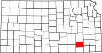 | |
| Unincorporated communities | ||
| Townships | ||