Loriol-du-Comtat
| Loriol-du-Comtat | ||
|---|---|---|
|
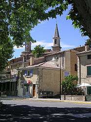
The centre of the village of Loriol-du-Comtat | ||
| ||
 Loriol-du-Comtat | ||
|
Location within Provence-A.-C.d'A. region  Loriol-du-Comtat | ||
| Coordinates: 44°04′38″N 5°00′05″E / 44.0772°N 5.0014°ECoordinates: 44°04′38″N 5°00′05″E / 44.0772°N 5.0014°E | ||
| Country | France | |
| Region | Provence-Alpes-Côte d'Azur | |
| Department | Vaucluse | |
| Arrondissement | Carpentras | |
| Canton | Carpentras-Nord | |
| Intercommunality | Ventoux-Comtat Venaissin | |
| Government | ||
| • Mayor | Michel Nicolet | |
| Area1 | 11.29 km2 (4.36 sq mi) | |
| Population (2006)2 | 2,234 | |
| • Density | 200/km2 (510/sq mi) | |
| Time zone | CET (UTC+1) | |
| • Summer (DST) | CEST (UTC+2) | |
| INSEE/Postal code | 84067 / 84870 | |
| Elevation |
31–93 m (102–305 ft) (avg. 65 m or 213 ft) | |
|
1 French Land Register data, which excludes lakes, ponds, glaciers > 1 km² (0.386 sq mi or 247 acres) and river estuaries. 2 Population without double counting: residents of multiple communes (e.g., students and military personnel) only counted once. | ||
.svg.png)
Loriol-du-Comtat is a commune in the Vaucluse department in the Provence-Alpes-Côte d'Azur region in southeastern France.
See also
References
| Wikimedia Commons has media related to Loriol-du-Comtat. |
This article is issued from Wikipedia - version of the 10/8/2016. The text is available under the Creative Commons Attribution/Share Alike but additional terms may apply for the media files.