Pernes-les-Fontaines
| Pernes-les-Fontaines | ||
|---|---|---|
|
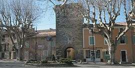
City gate | ||
| ||
 Pernes-les-Fontaines | ||
|
Location within Provence-A.-C.d'A. region  Pernes-les-Fontaines | ||
| Coordinates: 43°59′55″N 5°03′35″E / 43.9986°N 5.0597°ECoordinates: 43°59′55″N 5°03′35″E / 43.9986°N 5.0597°E | ||
| Country | France | |
| Region | Provence-Alpes-Côte d'Azur | |
| Department | Vaucluse | |
| Arrondissement | Carpentras | |
| Canton | Pernes-les-Fontaines | |
| Intercommunality | Les Sorgues du Comtat | |
| Government | ||
| • Mayor (2001–2008) | Pierre Gabert | |
| Area1 | 51.12 km2 (19.74 sq mi) | |
| Population (2006)2 | 10,607 | |
| • Density | 210/km2 (540/sq mi) | |
| Time zone | CET (UTC+1) | |
| • Summer (DST) | CEST (UTC+2) | |
| INSEE/Postal code | 84088 / 84210 | |
| Elevation |
36–263 m (118–863 ft) (avg. 82 m or 269 ft) | |
|
1 French Land Register data, which excludes lakes, ponds, glaciers > 1 km² (0.386 sq mi or 247 acres) and river estuaries. 2 Population without double counting: residents of multiple communes (e.g., students and military personnel) only counted once. | ||
.svg.png)
Pernes-les-Fontaines is a commune in the Vaucluse department in the Provence-Alpes-Côte d'Azur region in southeastern France.
See also
References
| Wikimedia Commons has media related to Pernes-les-Fontaines. |
This article is issued from Wikipedia - version of the 1/28/2015. The text is available under the Creative Commons Attribution/Share Alike but additional terms may apply for the media files.