Robion
| Robion | ||
|---|---|---|
|
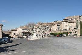
Robion's square | ||
| ||
 Robion | ||
|
Location within Provence-A.-C.d'A. region  Robion | ||
| Coordinates: 43°50′42″N 5°06′48″E / 43.845°N 5.1133°ECoordinates: 43°50′42″N 5°06′48″E / 43.845°N 5.1133°E | ||
| Country | France | |
| Region | Provence-Alpes-Côte d'Azur | |
| Department | Vaucluse | |
| Arrondissement | Apt | |
| Canton | Cavaillon | |
| Government | ||
| • Mayor (2014–2020) | Patrick Sintès | |
| Area1 | 17.07 km2 (6.59 sq mi) | |
| Population (2006)2 | 1,027 | |
| • Density | 60/km2 (160/sq mi) | |
| Time zone | CET (UTC+1) | |
| • Summer (DST) | CEST (UTC+2) | |
| INSEE/Postal code | 84099 / 84440 | |
| Website | http://www.robion.fr | |
|
1 French Land Register data, which excludes lakes, ponds, glaciers > 1 km² (0.386 sq mi or 247 acres) and river estuaries. 2 Population without double counting: residents of multiple communes (e.g., students and military personnel) only counted once. | ||
.svg.png)
Robion is a commune in the Vaucluse department in the Provence-Alpes-Côte d'Azur region in southeastern France. The new part of the village runs along the D2 road, and the old part of the village is clustered at the foot of the Luberon mountain.
Geography
The Calavon, locally called Coulon, flows westward through the middle of the commune.
See also
References
| Wikimedia Commons has media related to Robion. |
This article is issued from Wikipedia - version of the 9/23/2016. The text is available under the Creative Commons Attribution/Share Alike but additional terms may apply for the media files.