Cumberland Parkway
| |
|---|---|
| Route information | |
| Length: | 92.313 mi[1] (148.563 km) |
| Major junctions | |
| West end: |
|
| East end: |
|
| Location | |
| Counties: | Barren, Metcalfe, Adair, Russell, Pulaski |
| Highway system | |

The Louie B. Nunn Cumberland Parkway is an 92-mile-long (148 km) east–west controlled-access highway in the U.S. state of Kentucky, extending from Barren County in the west to the east side Somerset in the east. It is one of nine highways that are part of Kentucky's parkway system.
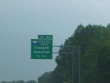
The parkway begins at an interchange with Interstate 65 (exit 43) between Smiths Grove and Park City. It travels east through rolling farmland to its eastern terminus at Kentucky Route 80 on the east side of Somerset. The road parallels Kentucky Route 80 for its entire length. The parkway passes the cities of Glasgow, Edmonton, Columbia, and Russell Springs. It passes near two popular state parks: Lake Cumberland State Resort Park and Barren River Lake State Resort Park. The length of the parkway is designated unsigned Kentucky Route 9008 (LN 9008).
The road is named after Louie B. Nunn, a former Kentucky governor from Barren County who was instrumental in the road's creation. Originally called the Cumberland Parkway from its opening in 1972-1973, it was renamed for Nunn in 2000.
Presumably, the Nunn Parkway was built to Interstate Highway standards at its time of construction aside from some at-grade intersections and traffic signals near its east end, which were eliminated in 2010 by constructing a northwestern bypass around Somerset. The east end of the parkway is currently a partial cloverleaf at U.S. 27. An extension to complete the northern bypass is in the works.
History
The Nunn Parkway, as with all nine parkways, was originally a toll road. By Kentucky state law, toll collection ceases when enough toll has been collected or funds received from other sources, such as a legislative appropriation, to pay off the construction bonds for the parkway. In the case of the Nunn, toll booths were removed in 2003 because of a bill in the United States Congress sponsored by Hal Rogers (R-KY), which included an appropriation to pay off the bonds on the parkway as well as the Daniel Boone Parkway in eastern Kentucky. The state legislature then renamed the Boone Parkway for Rogers, which sparked a controversy among residents of the region and the offspring of Boone. Nunn tried to calm the controversy by suggesting the state rename the Nunn Parkway for Rogers instead, restoring the Boone name, saying that the Cumberland Parkway had been named for Nunn without his consent anyway.
Toll plazas
The road had three toll plazas:
- Mile Marker 3 — Bon Ayr (in Barren County)
- Exit 27 (Edmonton)[2]
- Exit 62 (Russell Springs)
New interchange in Glasgow
On May 28, 2015, a new interchange on the Louie B. Nunn Cumberland Parkway west of Glasgow was opened to serve the western extension of the Veterans Outer Loop. The eastern extension of that road has been opened in early 2012, complete with the opening of exit 15, which serves the eastern extension of Veterans Outer Loop, designated at KY 1519. The state highway designation for the western extension was announced as Kentucky Route 3600. Upon completion of the new western extension of the Veterans Outer Loop, it includes the new on- and off-ramps of the Cumberland Parkway, and a new at-grade intersection with Kentucky Route 1297[3][4][5][6][7]
Eastern extension
In the early 2010s, the parkway was re-routed from its original alignment near Somerset to end at US 27 north of town. Most recently in the mid 2010s, the parkway was extended further to include two additional interchanges to serve KY 2227 KY 1247 and KY 39, and to end at an interchange with KY 80 on the northeast side of town. That project was completed in 2016.
Exit list
| County | Location | mi[1] | km | Exit | Destinations | Notes |
|---|---|---|---|---|---|---|
| Barren | | 0.000 | 0.000 | 1 | Western terminus; signed as exits 1B (south) and 1A (north) | |
| Glasgow | 8.704 | 14.008 | 8 | Opened May 28, 2015 | ||
| 11.467 | 18.454 | 11 | ||||
| 14.027 | 22.574 | 14 | ||||
| 15.374 | 24.742 | 15 | ||||
| Metcalfe | Edmonton | 27.400 | 44.096 | 27 | ||
| 29.795 | 47.950 | 30 | Opened late 2014 | |||
| Adair | Columbia | 46.000 | 74.030 | 46 | ||
| 48.886 | 78.674 | 49 | ||||
| Russell | Russell Springs | 62.419 | 100.454 | 62 | ||
| Pulaski | | 78.349 | 126.090 | 78 | ||
| Somerset | 86.104 | 138.571 | 86 | |||
| 88.258 | 142.037 | 88 | Cloverleaf interchange; signed as exits 88A (south) and 88B (north) | |||
| 89.111 | 143.410 | 89 | ||||
| 90.331 | 145.374 | 90 | Single-point urban interchange | |||
| 91.311 | 146.951 | 91 | ||||
| 92.343 | 148.612 | 92 | Eastern terminus | |||
| 1.000 mi = 1.609 km; 1.000 km = 0.621 mi | ||||||
References
- 1 2 "Kentucky Transportation Cabinet - Division of Planning - Highway Information System Official Milepoint Route Log Extract". Archived from the original on 2007-04-30. Retrieved 2007-04-08.
- ↑ Elkins, H.B. (2001). Signs and sights in Metcalfe County, Ky.. Retrieved June 16, 2016.
- ↑ Forsythe, Lauren. "Glasgow Outer Loop to be Completed Next Year".
- ↑ "Multiple road projects on tap". The Daily News. Kentucky.
- ↑ Times, BY GINA KINSLOW Glasgow Daily. "Expect lane closures this week on Happy Valley Road".
- ↑ Kinslow, Gina (June 5, 2015). "Roadway project comes full circle". Glasgow Daily Times, pages A1 and A8. Retrieved June 5, 2015.
- ↑ GLASGOW OUTER LOOP RIBBON CUTTING CEREMONY Archived July 15, 2015, at the Wayback Machine.. WBKO. June 4, 2015. Retrieved June 8, 2015.