Elizabethtown, Kentucky
| Elizabethtown, Kentucky | |
|---|---|
| City | |
|
Hardin County Courthouse in downtown Elizabethtown | |
| Nickname(s): E-town or E'town | |
 Location of Elizabethtown, Kentucky | |
| Coordinates: 37°42′N 85°52′W / 37.700°N 85.867°WCoordinates: 37°42′N 85°52′W / 37.700°N 85.867°W | |
| Country | United States |
| State | Kentucky |
| County | Hardin |
| Area | |
| • Total | 25.8 sq mi (66.9 km2) |
| • Land | 25.4 sq mi (65.7 km2) |
| • Water | 0.5 sq mi (1.2 km2) |
| Elevation | 725 ft (221 m) |
| Population (2010) | |
| • Total | 28,531 |
| • Density | 936.6/sq mi (361.6/km2) |
| Time zone | Eastern (EST) (UTC-5) |
| • Summer (DST) | EDT (UTC-4) |
| ZIP codes | 42701–42702 |
| Area code(s) | 270 & 364 |
| FIPS code | 21-24274 |
| GNIS feature ID | 0491640 |
| Website |
www |

Elizabethtown is a home rule-class city[1] in Hardin County, Kentucky, in the United States. It is the seat of its county. The population was estimated at 29,335 by the United States Census in 2012, making it the 10th-largest city in the state.[2] It is included in (and the principal city of) the Elizabethtown–Fort Knox, Kentucky Metropolitan Statistical Area, which is included in the Louisville/Jefferson County–Elizabethtown–Madison, Kentucky-Indiana Combined Statistical Area.
Geography
According to the United States Census Bureau, the city has a total area of 25.8 square miles (67 km2), of which 25.4 square miles (66 km2) is land and 0.5 square miles (1 km2) (1.77%) is water.
On the list (by population) of all metropolitan statistical areas as defined by the United States Census Bureau, Elizabethtown has a population of 28,531. Population estimates are current as of the 2010 Census. Metropolitan statistical area names are current as of December 1, 2005. The Elizabethtown metropolitan area includes Radcliff, a city about three-fourths the size of Elizabethtown; the housing areas of the Fort Knox Military Installation; the unincorporated town of Rineyville, where Abraham Lincoln's school teacher, Zachariah Riney lived; and other communities such as Vine Grove, Glendale, Sonora, West Point, and Upton.
Climate
The climate in this area is characterized by hot, humid summers and generally mild to cool winters. According to the Köppen Climate Classification system, Elizabethtown has a humid subtropical climate, abbreviated "Cfa" on climate maps.[3]
History
Established in 1793, the Hardin County was named for Colonel John Hardin, an Indian fighter who worked with tribes in the local area. In a few years, professional men and tradesmen came to live in the area. In 1793, Colonel Hynes had 30 acres (120,000 m2) of land (until then known as the Severn's Valley Settlement[4]) surveyed and laid off into lots and streets to establish Elizabethtown. Named in honor of his wife, Elizabethtown was legally established in 1797.[5][6]
Thomas Lincoln helped Samuel Haycraft build a millrace at Haycraft's mill on Valley Creek. After Lincoln married Nancy Hanks in 1806, they lived in a log cabin built in Elizabethtown. Their daughter, Sarah, was born there in 1807. Soon after, they moved to the Sinking Spring Farm, where Abraham Lincoln was born in 1809. Thomas Lincoln took his family to Indiana in 1816. After his wife died in 1818, he returned to Elizabethtown and married Sarah Bush Johnston, widowed since 1816. She and her three children accompanied Thomas back to Indiana, where Sarah was stepmother to Thomas' two children.
On March 5, 1850, the Commonwealth of Kentucky granted a charter to the Louisville and Nashville Railroad Company authorizing it to raise funds and built a railroad from Louisville to the Tennessee state line in the direction of Nashville. John L. Helm, the grandson of Capt. Thomas Helm, became the president of the railroad in October 1854; he directed construction of the main stem of the rail line through Elizabethtown. The rail line was completed to Elizabethtown in 1858, with the first train arriving on June 15, 1858. The opening of the railroad brought economic growth to Elizabethtown, which became an important trade center along the railroad and a strategic point during the Civil War.
On December 27, 1862, Confederate General John Hunt Morgan and his 3,000-man cavalry attacked Elizabethtown. During the battle, more than 100 cannonballs were fired into the town. Although he successfully captured Elizabethtown, Morgan's chief goal was to disrupt the railroad and northern transportation. He proceeded north along the railroad, burning trestles and destroying sections of the track. After the battle, one cannonball was found lodged in the side of a building on the public square. After the building burned in 1887 and was rebuilt, the cannonball was replaced in the side wall, as close to its original site as possible, where it remains in the present day.
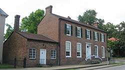
From 1871 to 1873 during the Reconstruction era, the Seventh Cavalry and a battalion of the Fourth Infantry, led by General George Armstrong Custer, were stationed in Elizabethtown. The military were assigned to suppress the local Ku Klux Klan under the Enforcement Acts, as their members had been attacking freedmen and other Republicans. They also broke up illegal distilleries, which began to flourish in the South after the Civil War. General Custer and his wife Elizabeth lived in a small cottage behind Aunt Beck Hill's boarding house, now known as the Brown-Pusey House.
Culture
The town is regionally referred to as "E-town" (sometimes with an apostrophe in place of the dash). It is notable as one of two larger towns (the other being Bowling Green) along I-65 between Louisville and Nashville. The movie Elizabethtown (2005) was named after the town; most of the footage was filmed in Versailles and Louisville because Elizabethtown has lost much of its historic architecture in recent years due to commercial development.
Alcohol sales
Elizabethtown is officially classified by the Kentucky Department of Alcoholic Beverage Control (ABC) as being in a "moist county". Under ABC terminology, "moist" indicates that at least one city within a county has approved packaged alcohol sales. In popular usage, the term "moist" more often refers to the city's former status as allowing by-the-drink sales in restaurants, but not package sales.
Despite the county being a dry county, alcoholic drink sales have long been allowed in restaurants seating at least 100 diners and deriving at least 70% of their total sales from food. Beer, wine and spirits can be purchased at licensed liquor stores, drug stores and grocery outlets, beer can be purchased at most convenience stores . The locals classify this as a "damp" or "moist" county. In 2011, the residents of Elizabethtown, Radcliff, and Vine Grove voted to allow properly licensed businesses to sell package liquor, wine, and beer.[7]
Transportation
The city is served by the Elizabethtown Regional Airport (EKX) and the Elizabethtown Airport Board is currently exploring options to bring commercial services to the city.[8]
Demographics
| Historical population | |||
|---|---|---|---|
| Census | Pop. | %± | |
| 1810 | 181 | — | |
| 1830 | 601 | — | |
| 1840 | 979 | 62.9% | |
| 1860 | 556 | — | |
| 1870 | 1,743 | 213.5% | |
| 1880 | 2,526 | 44.9% | |
| 1890 | 2,260 | −10.5% | |
| 1900 | 1,861 | −17.7% | |
| 1910 | 1,970 | 5.9% | |
| 1920 | 2,530 | 28.4% | |
| 1930 | 2,590 | 2.4% | |
| 1940 | 3,667 | 41.6% | |
| 1950 | 5,807 | 58.4% | |
| 1960 | 9,641 | 66.0% | |
| 1970 | 11,748 | 21.9% | |
| 1980 | 15,380 | 30.9% | |
| 1990 | 18,167 | 18.1% | |
| 2000 | 22,542 | 24.1% | |
| 2010 | 28,531 | 26.6% | |
| Est. 2015 | 29,678 | [9] | 4.0% |
As of the census of 2010,[11] there were 28,531 people, 15,711 households, and 9,345 families residing in the city. The population density was 936.6/mi2 (361.6/km2). There were 12,664 housing units at an average density of 490.5/mi² (189.4/km²). The racial makeup of the city was 80.4% White (78.1% non-Hispanic), 19.6% African American, 0.34% Native American, 2.6% Asian, 0.18% Pacific Islander, 1.3% from other races, and 3.4% from two or more races. Hispanics or Latinos of any race were 4.3% of the population.
There were 15,711 households out of which 30.5% had children under the age of 18 living with them, 43.2% were married couples living together, 15.1% had a female householder with no husband present, 4.4% had a male householder with no wife present, and 37.3% were non-families. 32.1% of all households were made up of individuals and 10.9% had someone living alone who was 65 years of age or older. The average household size was 2.34 and the average family size was 2.94.
The age distribution was 25.1% under 18, 9.8% from 18 to 24, 27.5% from 25 to 44, 24.4% from 45 to 64, and 13.2% who were 65 or older. The median age was 35.4 years. For every 100 females there were 91.9 males. For every 100 females age 18 and over, there were 87.4 males.
Full economic data for Kentucky locations from the 2010 Census has not yet been released. As of the 2010 Census, median income for a household in the city was $40,720, and the median income for a family was $54,699. Full-time male workers had a median income of $43,406 versus $30,310 for females. The per capita income for the city was $23,627. As of the 2000 Census,[12] about 8.5% of families and 10.5% of the population were below the poverty line, including 14.6% of those under age 18 and 9.1% of those age 65 or over.
In 2000, Hardin County, Kentucky and LaRue County, Kentucky were defined as the Elizabethtown, KY Metropolitan Statistical Area by the Bureau of the Census; the name of the region was changed in 2013 to Elizabethtown–Fort Knox, KY Metropolitan Statistical Area. It is part of the Louisville-Elizabethtown-Madison, KY-IN Combined Statistical Area.
Education
Elizabethtown Independent Schools
- Elizabethtown High School
- T.K. Stone Middle School
- Morningside Elementary School
- Helmwood Heights Elementary School
- Valley View Educational Center
Hardin County Schools
The Hardin County Schools are another district that encompasses some of the city limits.
Here are the schools located within the city limits:
- Bluegrass Middle School
- Central Hardin High School[13]
- G.C. Burkhead Elementary School
- Heartland Elementary School
- Lincoln Trail Elementary School
- New Highland Elementary School
Although New Highland Elementary, Bluegrass Middle School, and John Hardin High School have an Elizabethtown mailing address, and some Elizabethtown residents are zoned into those schools, they are actually within the city limits of neighboring Radcliff.[13] Conversely, Central Hardin High is within the city limits of Elizabethtown but has a mailing address of Cecilia.
Private schools
- Saint James Catholic Regional School
- Elizabethtown Christian Academy
- Gloria Dei Lutheran School
Post-secondary education
Elizabethtown is home to Elizabethtown Community and Technical College, a member of the Kentucky Community and Technical College System, as well as Empire Beauty School formerly the Hair Design School on Westport Road. Also, Western Kentucky University has a regional campus located on post at Fort Knox and in a building that is shared with ECTC in Elizabethtown.
Weekend education
The Elizabethtown Japanese School (エリザベスタウン日本人補習校 Erizabesutaun Nihonjin Hoshūkō), a weekend Japanese program, holds its classes at the Elizabethtown Community and Technical College.[14][15]
Sister cities
Elizabethtown has one sister city, as designated by Sister Cities International:
Churches
The first Baptist settlement west of the Alleghany Mountains was in Elizabethtown at Severns Valley Baptist Church, named after the first name of Elizabethtown. Catholics came west from Nelson County and settled at Colesburg at St. Claire Parish before coming to St. James Parish in Elizabethtown. Lucinda Helm helped bring United Methodists into Elizabethtown and they immortalized her in naming the Helm Memorial United Methodist Church, today simply called MUMC. More than 12 denominations are represented by over 100 churches in Elizabethtown.
Notable people
- Nathan Adcock, current MLB pitcher for the Kansas City Royals[17]
- Philip Arnold, confidence trickster, most famous for the diamond hoax of 1872[18]
- Antwain Barbour, American professional basketball player and former member of the Kentucky Wildcats men's basketball team.[19]
- Ben M. Bogard, clergyman, founder of the American Baptist Association, born in Elizabethtown in 1868[20]
- Mark Bradley (baseball), an outfielder for the New York Mets and Los Angeles Dodgers from 1981-1983.[21]
- John Y. Brown, 31st Governor of Kentucky and former Representative of Kentucky's 2nd district (1873–1877) & 5th district (1859–1861)[22]
- Brandon Deaderick, NFL defensive tackle drafted by the New England Patriots and currently plays for the Jacksonville Jaguars[23]
- Steve Delabar, MLB relief pitcher for the Toronto Blue Jays[24]
- Greg Downs, award-winning author[25]
- Sarah Lincoln Grigsby, sister of Abraham Lincoln, was born in Elizabethtown
- Benjamin Hardin Helm, Brigadier General, Confederate States Army[26]
- John LaRue Helm, 18th and 24th Governor of Kentucky[27]
- Walter Dee Huddleston, U.S. Senator from 1973 to 1985[28]
- Andrew Hynes, founder of Elizabethtown, which he named after his wife[29]
- Steve Jameson, award-winning painter and children's book illustrator[30]
- Joshua Jewett, former Representative of the 5th district, (1855–1859)[31]
- Keen Johnson, 45th Governor of Kentucky[32]
- Sarah Bush Johnston, second wife of Thomas Lincoln and stepmother to President Abraham Lincoln
- Thomas Lincoln, father of President Abraham Lincoln
- Danny Lloyd, actor in The Shining
- Douglas Lucas, singer-songwriter and musician with Sony/ATV Music Publishing[33][34]
- Charles B. Middleton, stage and film actor, famous for his role as Ming the Merciless in the Flash Gordon movie serials[35]
- Kenny Perry, professional PGA Tour golfer[36]
- Todd Perry, former NFL offensive guard for the Chicago Bears and Miami Dolphins[37]
- Steffphon Pettigrew, professional basketball player
- Kelly Rutherford, film actress, famous for her roles on Generations, Melrose Place, Gossip Girl and The Adventures of Brisco County, Jr.[38][39][40]
- Chris Todd, Auburn Tigers quarterback[41]
- Daniel Martin Moore, the singer-songwriter and musician was born in Elizabethtown.
In fiction
Elizabethtown is the eponym of the film Elizabethtown starring Orlando Bloom and Kirsten Dunst. The film was known for the Manic Pixie Dream Girl trope being created in a review of Dunst's character.
References
- ↑ "Summary and Reference Guide to House Bill 331 City Classification Reform" (PDF). Kentucky League of Cities. Retrieved December 30, 2014.
- ↑ Finley, Marty (2013). "Census population estimates: E'town breaks into Ky.'s top 10". The News-Enterprise. Retrieved 2013-09-20.
- ↑ "Elizabethtown, Kentucky Köppen Climate Classification (Weatherbase)". Weatherbase.
- ↑ Commonwealth of Kentucky. Office of the Secretary of State. Land Office. "Elizabethtown, Kentucky". Accessed 25 Jul 2013.
- ↑ Rennick, Robert M. (1987). Kentucky Place Names. University Press of Kentucky. p. 90. Retrieved 2013-04-28.
- ↑ Gannett, Henry (1905). The Origin of Certain Place Names in the United States. Govt. Print. Off. p. 116.
- ↑ Finley, Marty (October 4, 2011). "Elizabethtown residents choose to expand sales". The News-Enterprise. Elizabethtown, Kentucky. Retrieved March 1, 2012.
- ↑ "Progress slows in deal to bring airline to E'town".
- ↑ "Annual Estimates of the Resident Population for Incorporated Places: April 1, 2010 to July 1, 2015". Retrieved July 2, 2016.
- ↑ "Census of Population and Housing". Census.gov. Retrieved June 4, 2015.
- ↑ "American FactFinder". United States Census Bureau. Retrieved 2011-05-14.
- ↑ "American FactFinder". United States Census Bureau. Retrieved 2008-01-31.
- 1 2 "State Primary Road System: Hardin County" (PDF). Kentucky Transportation Cabinet. July 2011. Retrieved August 5, 2011. On this map, Elizabethtown is displayed with a pink background and Radcliff in green. For Central Hardin's location, follow U.S. 62 west of downtown Elizabethtown. For John Hardin High's location, zoom in to the region where the two cities meet.
- ↑ "補習授業校リスト" (Archive). Consulate General of Japan in Nashville. Retrieved on February 15, 2015. "(2)エリザ スタウン日本人補習校 ( Elizabethtown Japanese School ) 学校所在地 c/o Elizabethtown Community and Technical College 600 College Street Road, Elizabethtown , KY 42701"
- ↑ Home. Elizabethtown Japanese School. Retrieved on April 5, 2015. "エリザベスタウン日本人補習校 c/o ECTC 600 College Street Road Elizabethtown, Kentucky, U.S.A."
- ↑ Sister City
- ↑ "Nathan Adcock Statistics and History - Baseball-Reference.com". Baseball-Reference.com.
- ↑ Woodard, Bruce A. (1967). Diamonds in the Salt. Boulder, CO: Pruett Press. p. 200.
- ↑ University of Kentucky. "UK Wildcats - Basketball (M)". University of Kentucky - Official Athletics Site.
- ↑ "Benjamin Marcus Bogard (1868–1951)". encyclopediaofarkansas.net. Retrieved August 4, 2013.
- ↑ "Mark Bradley Statistics and History - Baseball-Reference.com". Baseball-Reference.com.
- ↑ Harrison in The Kentucky Encyclopedia, pp. 129–130
- ↑ "Brandon Deaderick". NFL.com.
- ↑ Caple, Jim (2011-09-14). "Steve Delabar, Alex Liddi, Austin Romine exemplify great MLB stories of September - ESPN". Espn.go.com. Retrieved 2011-09-15.
- ↑ Sarah Goebel. "Elizabethtown Book".
- ↑ Barefoot, Daniel W. (2005). Let Us Die Like Brave Men: Behind the Dying Words of Confederate Warriors. North Carolina: John F. Blair. ISBN 0-89587-311-7.
- ↑ "Kentucky Governor John Larue Helm". National Governors Association. Retrieved April 2, 2012.
- ↑ http://www.forbes.com/profile/walter-huddleston
- ↑ http://www.touretown.com/portals/0/pdf/Driving%20Tour%20PDF.pdf
- ↑ "NWS - National Watercolor Society - Home". National Watercolor Society. Retrieved 2012-01-23.
- ↑
- United States Congress. "Elizabethtown, Kentucky (id: J000106)". Biographical Directory of the United States Congress.
- ↑ "Kentucky Governor Keen Johnson". National Governors Association. Retrieved April 4, 2012.
- ↑ "Handsome Death". LEO Weekly.
- ↑ "Douglas Lucas". Myspace.
- ↑ "Charles B Middleton - Moviefone". AOL Moviefone.
- ↑ "Kenny Perry".
- ↑ "Todd Perry". ESPN.com.
- ↑ "Yahoo TV".
- ↑ Kyle Darbyson. "Kelly Rutherford". AskMen.
- ↑ http://www.tvguide.com/celebrities/kelly-rutherford/bio/160328
- ↑ "Chris Todd". Auburn University.
Further reading
- McMurtry, Gerald R. (April 1938). "Elizabethtown, Kentucky, 1779–1879". Filson Club History Quarterly. 12 (2). Retrieved 2011-11-29.
External links
- City of Elizabethtown official site
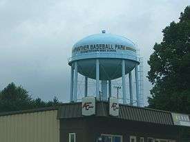
- "Elizabethtown's new $29 million, 150-acre youth sports complex"—The New York Times, September 6, 2011
Municipalities and communities of Hardin County, Kentucky, United States | ||
|---|---|---|
| Cities | 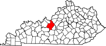 | |
| CDPs | ||
| Other unincorporated communities | ||
| Footnotes | ‡This populated place also has portions in an adjacent county or counties | |
