Lucas, Ohio
| Lucas, Ohio | |
|---|---|
| Village | |
|
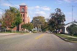
West Main Street in 2007 | |
 Location of Lucas, Ohio | |
 Location of Lucas in Richland County | |
| Coordinates: 40°42′14″N 82°25′12″W / 40.70389°N 82.42000°WCoordinates: 40°42′14″N 82°25′12″W / 40.70389°N 82.42000°W | |
| Country | United States |
| State | Ohio |
| County | Richland |
| Government | |
| • Mayor | Todd R. Hall |
| Area[1] | |
| • Total | 0.69 sq mi (1.79 km2) |
| • Land | 0.69 sq mi (1.79 km2) |
| • Water | 0 sq mi (0 km2) |
| Elevation[2] | 1,093 ft (333 m) |
| Population (2010)[3] | |
| • Total | 615 |
| • Estimate (2012[4]) | 606 |
| • Density | 891.3/sq mi (344.1/km2) |
| Time zone | Eastern (EST) (UTC-5) |
| • Summer (DST) | EDT (UTC-4) |
| ZIP code | 44843 |
| Area code(s) | 419 |
| FIPS code | 39-45276[5] |
| GNIS feature ID | 1048396[2] |
Lucas is a village in southeastern Richland County, Ohio, United States. Lucas is part of the Mansfield, Ohio Metropolitan Statistical Area.[6]
History
David Tucker, a New Hampshire resident, moved to Richland County in 1819, where he set in a proposal to buy land in the rural country of the county. He was granted this proposal in 1824, allowing him to buy land from the state at $1.25 per acre. After purchasing a mass quantity of land from the state, Tucker hired Mr. Steward to survey the land for auctioning out. David's brother, John, was placed in charge as the head attorney authored to sell land to incoming settlers and pioneers in 1829. The auction was advertised in the local handbill "The Mansfield Shield and Banner", in which the land was described as "as good as a wheat growing country as the state can have." In response to this statement, the land for three major wheat mills was bought that year and mills were built in the following months. The town officially built and commissioned a postal office later that year. In 1830, the Chicago Railroad Company paid for tracks to be laid down on the south side of town of the town as well as a depot. By 1834, the Lucas area was full of houses and shops, becoming a major rural center for Richland County, mostly due to being the first town in the county to receive federal aid in its building because the land where Lucas presided was a campsite of General John Brooks (governor) as he marched north from Mansfield during the War of 1812, thus qualifying it as a historical site at the time.[7] Currently three theories exist on how the Village of Lucas acquired its name:
- The town was named after the current at the time and 12th governor of Ohio, Robert Lucas.
- The town was named in honor of Governor Lucas's brother, a major land owner for the town.
- The town was named in honor of the Tucker brothers' mother's maiden name, Lucas.[8]
However the name came to be, the town of Lucas was officially established according to Ohio standards at the time in 1836.
Geography
Lucas is located at 40°42′14″N 82°25′12″W / 40.70389°N 82.42000°W (40.703773, -82.420024).[9] It lies southeast of Mansfield, a few miles from Interstate 71 on State Route 39. Lucas is surrounded by the Rocky Fork and Black Fork rivers, and the Charles Mill Lake to the east, and the Pleasant Hill Lake to the south. Lucas has many hills and forests and is part of the Mohican Valley area, along with Loudonville, Perrysville, Butler and Bellville. According to the United States Census Bureau, the village has a total area of 0.69 square miles (1.79 km2), all land.[1]
Demographics
| Historical population | |||
|---|---|---|---|
| Census | Pop. | %± | |
| 1870 | 312 | — | |
| 1880 | 381 | 22.1% | |
| 1890 | 347 | −8.9% | |
| 1900 | 306 | −11.8% | |
| 1910 | 272 | −11.1% | |
| 1920 | 337 | 23.9% | |
| 1930 | 369 | 9.5% | |
| 1940 | 484 | 31.2% | |
| 1950 | 573 | 18.4% | |
| 1960 | 719 | 25.5% | |
| 1970 | 771 | 7.2% | |
| 1980 | 753 | −2.3% | |
| 1990 | 730 | −3.1% | |
| 2000 | 620 | −15.1% | |
| 2010 | 615 | −0.8% | |
| Est. 2015 | 604 | [10] | −1.8% |
| Sources:[11][12] | |||
2010 census
As of the census[3] of 2010, there were 615 people, 237 households, and 176 families residing in the village. The population density was 891.3 inhabitants per square mile (344.1/km2). There were 269 housing units at an average density of 389.9 per square mile (150.5/km2). The racial makeup of the village was 98.0% White, 0.3% African American, and 1.6% from two or more races.
There were 237 households of which 42.2% had children under the age of 18 living with them, 50.2% were married couples living together, 16.9% had a female householder with no husband present, 7.2% had a male householder with no wife present, and 25.7% were non-families. 21.5% of all households were made up of individuals and 8.4% had someone living alone who was 65 years of age or older. The average household size was 2.59 and the average family size was 2.97.
The median age in the village was 34.9 years. 29.1% of residents were under the age of 18; 9.4% were between the ages of 18 and 24; 27.8% were from 25 to 44; 21.9% were from 45 to 64; and 11.7% were 65 years of age or older. The gender makeup of the village was 49.1% male and 50.9% female.
2000 census
As of the census[5] of 2000, there were 620 people, 246 households, and 172 families residing in the village. The population density was 1,037.1 people per square mile (399.0/km²). There were 268 housing units at an average density of 448.3 per square mile (172.5/km²). The racial makeup of the village was 97.42% White, 0.81% African American, 0.48% Native American, 0.16% from other races, and 1.13% from two or more races. Hispanic or Latino of any race were 0.16% of the population.
There were 246 households out of which 33.7% had children under the age of 18 living with them, 53.7% were married couples living together, 12.2% had a female householder with no husband present, and 29.7% were non-families. 24.4% of all households were made up of individuals and 11.4% had someone living alone who was 65 years of age or older. The average household size was 2.52 and the average family size was 3.01.
In the village the population was spread out with 27.6% under the age of 18, 7.4% from 18 to 24, 31.3% from 25 to 44, 20.3% from 45 to 64, and 13.4% who were 65 years of age or older. The median age was 36 years. For every 100 females 8=)there were 96.2 males. For every 100 females age 18 and over, there were 87.1 males.
The median income for a household in the village was $37,813, and the median income for a family was $42,917. Males had a median income of $36,094 versus $20,625 for females. The per capita income for the village was $17,653. About 2.7% of families and 6.2% of the population were below the poverty line, including 3.3% of those under age 18 and 7.8% of those age 65 or over.
Education and athletics
Lucas is in the Lucas Local School District. The district enrolls 584 students and administers 3 public schools including Lucas Elementary School, Lucas Heritage Middle School, and Lucas High School.[13]
The Lucas "Cubs" are a member of the Mid-Buckeye Conference, participating in sports such as baseball, football, basketball, track, cross country, girls volleyball and girls softball. With class sizes around 40 students, Lucas is one of the smallest schools in the state of Ohio with an athletic program.
In 2005, Angela Foss won the school's only individual state championship. She took first place at the state meet in the Pole Vault.
In 1991, The baseball team reached the final four (state semi-finals), and lost 1-0 (on an unearned run) to the eventual state champions, Parkway High School. Still, to this day, this is the only time in which a team from Lucas made the State Semi-finals.
In popular culture
In the film, The Shawshank Redemption, Andy tells Red about a hayfield in Buxton, Maine where Andy asked his wife to marry him. After being paroled, Red visits the field to retrieve items left for him by Andy near what has become known as the Shawshank tree. The actual site where that scene was filmed was in Lucas.
Notable people
- Louis Bromfield, Pulitzer Prize–winning author and world-famous conservationist
- Tim Seder, Dallas Cowboys and Jacksonville Jaguars placekicker
References
- 1 2 "US Gazetteer files 2010". United States Census Bureau. Retrieved 2013-01-06.
- 1 2 "US Board on Geographic Names". United States Geological Survey. 2007-10-25. Retrieved 2008-01-31.
- 1 2 "American FactFinder". United States Census Bureau. Retrieved 2013-01-06.
- ↑ "Population Estimates". United States Census Bureau. Retrieved 2013-06-17.
- 1 2 "American FactFinder". United States Census Bureau. Retrieved 2008-01-31.
- ↑ Baughman, Abraham J. (1908). History of Richland County, Ohio, from 1808 to 1908. S. J. Clarke. pp. 428–443.
- ↑ Lucas, OH: The Pleasant Valley of Homes. retrieved: September 28, 2104
- ↑ Spirit of Lucas. retrieved: September 28, 2014
- ↑ "US Gazetteer files: 2010, 2000, and 1990". United States Census Bureau. 2011-02-12. Retrieved 2011-04-23.
- ↑ "Annual Estimates of the Resident Population for Incorporated Places: April 1, 2010 to July 1, 2015". Retrieved July 2, 2016.
- ↑ "Census of Population and Housing". United States Census Bureau. Retrieved 2013-12-24.
- ↑ Data in historical populations table from US Census, 1890; US Census, 1920; US Census, 1950; US Census, 1970; US Census, 2000; "American Factfinder". United States Census Bureau. Retrieved 2013-12-24.
- ↑ greatschools. "Lucas Local School District Profile". Retrieved 2013-12-04.
Municipalities and communities of Richland County, Ohio, United States | ||
|---|---|---|
| Cities | 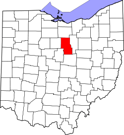 | |
| Villages | ||
| Townships | ||
| Unincorporated communities | ||
| Ghost towns | ||
| Footnotes | ‡This populated place also has portions in an adjacent county or counties | |