Lunar Orbiter 2
| Mission type | Lunar orbiter |
|---|---|
| Operator | NASA |
| COSPAR ID | 1966-100A |
| SATCAT № | 2534 |
| Mission duration | 339 days |
| Spacecraft properties | |
| Manufacturer | Langley Research Center |
| Launch mass | 385.6 kilograms (850 lb) |
| Start of mission | |
| Launch date | November 6, 1966, 23:21:00 UTC |
| Rocket | Atlas SLV-3 Agena-D |
| Launch site | Cape Canaveral LC-13 |
| End of mission | |
| Decay date | October 11, 1967 |
| Orbital parameters | |
| Reference system | Selenocentric |
| Semi-major axis | 2,694 kilometers (1,674 mi) |
| Eccentricity | 0.3499999940395355 |
| Periselene | 52 kilometers (32 mi) |
| Aposelene | 1,850 kilometers (1,150 mi) |
| Inclination | 11.899999618530273° |
| Period | 208.07000732421875 minutes |
| Lunar orbiter | |
| Orbital insertion | November 10, 1966 |
| Impact site | 3°00′N 119°06′E / 3.0°N 119.1°E |
| Orbits | 2,346 |
The Lunar Orbiter 2 spacecraft, part of the Lunar Orbiter Program, was designed primarily to photograph smooth areas of the lunar surface for selection and verification of safe landing sites for the Surveyor and Apollo missions. It was also equipped to collect selenodetic, radiation intensity, and micrometeoroid impact data.
The spacecraft was placed in a cislunar trajectory and injected into an elliptical near-equatorial lunar orbit for data acquisition after 92.5 hours flight time. The initial orbit was 196 by 1,850 kilometres (122 mi × 1,150 mi) at an inclination of 11.8 degrees. The perilune was lowered to 49.7 kilometres (30.9 mi) five days later after 33 orbits. A failure of the amplifier on the final day of readout, December 7, resulted in the loss of six photographs. On December 8, 1966 the inclination was altered to 17.5 degrees to provide new data on lunar gravity.
The spacecraft acquired photographic data from November 18 to 25, 1966, and readout occurred through December 7, 1966. A total of 609 high resolution and 208 medium resolution frames were returned, most of excellent quality with resolutions down to 1 metre (3 ft 3 in). These included a spectacular oblique picture of Copernicus crater, which was dubbed by the news media as one of the great pictures of the century. Accurate data were acquired from all other experiments throughout the mission. Three micrometeorite impacts were recorded. The spacecraft was used for tracking purposes until it impacted upon the lunar surface on command at 3.0 degrees N latitude, 119.1 degrees E longitude (selenographic coordinates) on October 11, 1967.
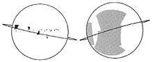
In 2011, NASA's Lunar Reconnaissance Orbiter Camera (LROC) was able to locate and image the precise impact point of the spacecraft. The debris from an impact angle of 45 degrees or more spreads out like butterfly wings.[1]
| Lunar Photographic Studies | Evaluation of Apollo and Surveyor landing sites |
|---|---|
| Meteoroid Detectors | Detection of micrometeoroids in the lunar environment |
| Caesium Iodide Dosimeters | Radiation environment en route to and near the Moon |
| Selenodesy | Gravitational field and physical properties of the Moon |
 Photograph taken by Lunar Orbiter 2 on November 20, 1966, 29 miles (47 km) above the lunar surface, over the Sea of Tranquility.
See also
- Lunar Orbiter Image Recovery Project
- Exploration of the Moon
- Lunar Orbiter 1
- Lunar Orbiter 3
- Lunar Orbiter 4
- Lunar Orbiter 5
References
- ↑ "Lunar Lost and Found - Rediscovering Old Wrecks on the Moon". Popular Mechanics. Retrieved 2011-11-04.
External links
- DESTINATION MOON: A history of the Lunar Orbiter Program (html version) 1976
- Lunar Orbiter Photo Gallery - Mission 2 at the Lunar and Planetary Institute
| Missions | .jpg) | |
|---|---|---|
| Related | ||
Spacecraft missions to the Moon | |||||||||||||||||||||||||||||||
|---|---|---|---|---|---|---|---|---|---|---|---|---|---|---|---|---|---|---|---|---|---|---|---|---|---|---|---|---|---|---|---|
| Current |
| ||||||||||||||||||||||||||||||
| Past |
| ||||||||||||||||||||||||||||||
| Planned |
| ||||||||||||||||||||||||||||||
| Proposed | |||||||||||||||||||||||||||||||
| Cancelled | |||||||||||||||||||||||||||||||
| See also | |||||||||||||||||||||||||||||||
Manned missions in italics. | |||||||||||||||||||||||||||||||
| Policy and history |
| |||||||
|---|---|---|---|---|---|---|---|---|
| Robotic programs |
| |||||||
| Human spaceflight programs |
| |||||||
| Individual featured missions (human and robotic) | ||||||||
| Communications and Navigation | ||||||||
| NASA lists | ||||||||
| ||||||||