Mahaska, Kansas
| Mahaska, Kansas | |
|---|---|
| City | |
 Location within Washington County and Kansas | |
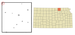
 KDOT map of Washington County (legend) | |
| Coordinates: 39°59′13″N 97°21′9″W / 39.98694°N 97.35250°WCoordinates: 39°59′13″N 97°21′9″W / 39.98694°N 97.35250°W | |
| Country | United States |
| State | Kansas |
| County | Washington |
| Area[1] | |
| • Total | 0.25 sq mi (0.65 km2) |
| • Land | 0.25 sq mi (0.65 km2) |
| • Water | 0 sq mi (0 km2) |
| Elevation | 1,598 ft (487 m) |
| Population (2010)[2] | |
| • Total | 83 |
| • Estimate (2012[3]) | 83 |
| • Density | 330/sq mi (130/km2) |
| Time zone | Central (CST) (UTC-6) |
| • Summer (DST) | CDT (UTC-5) |
| ZIP code | 66955 |
| Area code | 785 |
| FIPS code | 20-44150 [4] |
| GNIS feature ID | 0472620 [5] |
Mahaska is a city in Washington County, Kansas, United States. As of the 2010 census, the city population was 83.[6]
History
Mahaska was founded in 1887 by L. Bonham.[7] It was likely named for Chief Mahaska.[8]
The first post office in Mahaska was established in December 1887.[9]
In 1854, the Sixth Principal Meridian or 40th Parallel, approximately 1 mile northwest of the present day Mahaska. Originally marked in 1856, this site was the beginning point for land surveys for all land in Kansas, Nebraska, three-fourths of Colorado, most of Wyoming, and part of South Dakota. The original marker was rediscovered in 1976, then a new monument was dedicated in 1987.[7]
Geography
Mahaska is located at 39°59′13″N 97°21′9″W / 39.98694°N 97.35250°W (39.987024, -97.352376).[10] According to the United States Census Bureau, the city has a total area of 0.25 square miles (0.65 km2), all of it land.[1]
Mahaska is approximately 0.6 miles (0.97 km) south of the Nebraska-Kansas state line.
Demographics
| Historical population | |||
|---|---|---|---|
| Census | Pop. | %± | |
| 1910 | 246 | — | |
| 1920 | 210 | −14.6% | |
| 1930 | 218 | 3.8% | |
| 1940 | 195 | −10.6% | |
| 1950 | 179 | −8.2% | |
| 1960 | 160 | −10.6% | |
| 1970 | 122 | −23.7% | |
| 1980 | 119 | −2.5% | |
| 1990 | 98 | −17.6% | |
| 2000 | 107 | 9.2% | |
| 2010 | 83 | −22.4% | |
| Est. 2015 | 80 | [11] | −3.6% |
| U.S. Decennial Census | |||
2010 census
As of the census[2] of 2010, there were 83 people, 30 households, and 23 families residing in the city. The population density was 332.0 inhabitants per square mile (128.2/km2). There were 47 housing units at an average density of 188.0 per square mile (72.6/km2). The racial makeup of the city was 97.6% White and 2.4% from two or more races.
There were 30 households of which 43.3% had children under the age of 18 living with them, 66.7% were married couples living together, 10.0% had a female householder with no husband present, and 23.3% were non-families. 20.0% of all households were made up of individuals. The average household size was 2.77 and the average family size was 3.22.
The median age in the city was 37.5 years. 33.7% of residents were under the age of 18; 4.8% were between the ages of 18 and 24; 28.8% were from 25 to 44; 16.8% were from 45 to 64; and 15.7% were 65 years of age or older. The gender makeup of the city was 54.2% male and 45.8% female.
2000 census
As of the census[4] of 2000, there were 107 people, 39 households, and 31 families residing in the city. The population density was 430.8 people per square mile (165.3/km²). There were 49 housing units at an average density of 197.3 per square mile (75.7/km²). The racial makeup of the city was 93.46% White, 0.93% African American, 1.87% Native American, and 3.74% from two or more races.
There were 39 households out of which 38.5% had children under the age of 18 living with them, 64.1% were married couples living together, 12.8% had a female householder with no husband present, and 20.5% were non-families. 17.9% of all households were made up of individuals and 7.7% had someone living alone who was 65 years of age or older. The average household size was 2.74 and the average family size was 3.03.
In the city the population was spread out with 31.8% under the age of 18, 7.5% from 18 to 24, 26.2% from 25 to 44, 23.4% from 45 to 64, and 11.2% who were 65 years of age or older. The median age was 34 years. For every 100 females there were 101.9 males. For every 100 females age 18 and over, there were 97.3 males.
The median income for a household in the city was $24,375, and the median income for a family was $26,250. Males had a median income of $20,000 versus $19,583 for females. The per capita income for the city was $13,162. There were 19.2% of families and 21.6% of the population living below the poverty line, including 30.4% of under eighteens and none of those over 64.
Notable people
- Charles D. McAtee, former director of Kansas prison system
See also
References
- 1 2 "US Gazetteer files 2010". United States Census Bureau. Retrieved 2012-07-06.
- 1 2 "American FactFinder". United States Census Bureau. Retrieved 2012-07-06.
- ↑ "Population Estimates". United States Census Bureau. Retrieved 2013-05-29.
- 1 2 "American FactFinder". United States Census Bureau. Retrieved 2008-01-31.
- ↑ "US Board on Geographic Names". United States Geological Survey. 2007-10-25. Retrieved 2008-01-31.
- ↑ "2010 City Population and Housing Occupancy Status". U.S. Census Bureau. Retrieved November 3, 2011.
- 1 2 Mahaska City Website
- ↑ Kansas State Historical Society (1916). Biennial Report of the Board of Directors of the Kansas State Historical Society. Kansas State Printing Plant. p. 312.
- ↑ "Kansas Post Offices, 1828-1961, page 2". Kansas Historical Society. Archived from the original on October 9, 2013. Retrieved 27 June 2014.
- ↑ "US Gazetteer files: 2010, 2000, and 1990". United States Census Bureau. 2011-02-12. Retrieved 2011-04-23.
- ↑ "Annual Estimates of the Resident Population for Incorporated Places: April 1, 2010 to July 1, 2015". Retrieved July 2, 2016.
External links
| Wikimedia Commons has media related to Mahaska, Kansas. |
- City
- Schools
- USD 108, local school district
- Maps
- Mahaska City Map, KDOT
Municipalities and communities of Washington County, Kansas, United States | ||
|---|---|---|
| Cities | 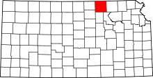 | |
| Unincorporated communities | ||
| Footnotes | ‡This populated place also has portions in an adjacent county or counties | |