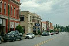
Marion Historic District (Marion, South Carolina)
|
Marion Historic District | |
 | |
  | |
| Location |
Roughly bounded by E. and W. Dozier, N. Montgomery, W. Baptist, and N. Wilcox Sts. (original), Roughly bounded by Railroad and N. Wilcox Aves., N. Main and W. Dozier Sts., also Wheeler, Lee and Arch Sts. (increase), Marion, South Carolina |
|---|---|
| Coordinates | 34°10′40″N 79°23′53″W / 34.17778°N 79.39806°WCoordinates: 34°10′40″N 79°23′53″W / 34.17778°N 79.39806°W |
| Area | 115 acres (47 ha) |
| Built | 1800 (original) and 1880 (increase) |
| Architectural style | Greek Revival (original) and Classical Revival, Late Victorian, Queen Anne (increase) |
| NRHP Reference # |
73001720[1] (original) 79003320[1] (increase) |
| Significant dates | |
| Added to NRHP | October 4, 1973 |
| Boundary increase | April 20, 1979 |
Marion Historic District dates from 1800.[2][3][4] It was listed on the National Register of Historic Places in 1973 and its boundaries were increased in 1979.[1]
References
- 1 2 3 National Park Service (2009-03-13). "National Register Information System". National Register of Historic Places. National Park Service.
- ↑ McClendon, Mrs. J. Malcolm; Mary Ann Eaddy (August 29, 1973). "Marion Historic District" (pdf). National Register of Historic Places - Nomination and Inventory. Retrieved 24 July 2012.
- ↑ Eaddy, Mary Ann; Mrs. J. Malcolm McClendon; Kappy McNulty (August 7, 1978). "Marion Historic District" (pdf). National Register of Historic Places - Nomination and Inventory. Retrieved 24 July 2012.
- ↑ "Marion Historic District, Marion County (Marion)". National Register Properties in South Carolina. South Carolina Department of Archives and History. Retrieved 24 July 2012.
| Topics |   | |
|---|---|---|
| Lists by county |
| |
| Lists by city | ||
| Other lists | ||
This article is issued from Wikipedia - version of the 11/28/2016. The text is available under the Creative Commons Attribution/Share Alike but additional terms may apply for the media files.