Marion Memorial Bridge
| Marion Memorial Bridge | |
|---|---|
 | |
| Carries |
|
| Crosses | Tennessee River and Nickajack Lake |
| Characteristics | |
| Design | Truss bridge |
| Total length | 1,870 feet |
| Longest span | 369 feet |
| History | |
| Opened | 1929 |
| Closed | 2012, demolished 2015 |
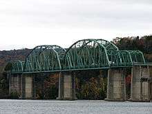
The Marion Memorial Bridge was a 4-span metal truss bridge which formerly carried U.S. Route 41 in Marion County, Tennessee. It was built in 1929. The main span was 369 feet, and the bridge had a total length of 1870 feet. The bridge was historic, and the Marion Memorial Bridge was listed on the National Register of Historic Places on October 25, 2007. The bridge featured an unusual truss configuration that is a hybrid of the Parker and K-Truss configurations. This bridge crossed the Tennessee River and Nickajack Lake. The bridge was replaced by a new concrete and box girder span which opened in November 2014, slightly delayed from its original completion date of August 2013 by conditions encountered in the construction of the replacement bridge footings. Since the construction of the new bridge's footings would involve blasting within 30 feet of the Marion Memorial Bridge, state officials closed the bridge to vehicle and pedestrian traffic on January 9, 2012, with traffic being re-routed to the Interstate 24 bridge south of the span. All of the metal trusses of the bridge were demolished and removed by June 2015. The bridge was delisted from the National Register in June 2016.
Some people in the community expressed the opinion that they would like to see the bridge preserved in some way.[1] Tennessee Department of Transportation officials say the bridge is costly to maintain, citing as an example the repainting cost of $1 million.[2]
This bridge was built before Nickajack Dam, a few miles downriver. The higher mean pool of the new reservoir was reason for the bridge to be raised from its original height.
A bridge of similar design in Meigs County, Tennessee, that carried Tennessee Highway 58 across the Hiwassee River was imploded in November, 2007,[3] along with another similar bridge that carried Highway 58 over the Tennessee River in Roane County.
See also
-
 Bridges portal
 -
 Tennessee portal
References
- ↑ Chattanooga Times Free Press, Marion Memorial Bridge span to be demolished, July 9, 2011
- ↑ Chattanooga Times Free Press, History falls in Hiwassee River, November 6, 2007
- ↑ Chattanooga Times Free Press, Bridge on National Register, November 4, 2007
External links
- Historic Bridges of Michigan and Elsewhere: Marion Memorial Bridge - Photos and information for the Marion Memorial Bridge.
| Crossings of the Tennessee River | ||||
|---|---|---|---|---|
| ||||
| Topics | |
|---|---|
| Lists by states |
|
| Lists by insular areas | |
| Lists by associated states | |
| Other areas | |
| |
Coordinates: 35°01′41″N 85°32′37″W / 35.0280°N 85.5435°W