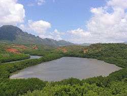
Menehune Fishpond
|
Menehune Fishpond | |
 | |
 | |
| Location | On the Hulēʻia River south of Lihue (viewable from lookout on south side of Puhi Road) |
|---|---|
| Nearest city | Lihue, Hawaii |
| Coordinates | 21°57′09″N 159°22′31″W / 21.9525°N 159.375278°WCoordinates: 21°57′09″N 159°22′31″W / 21.9525°N 159.375278°W |
| Area | 5 acres (2.0 ha) |
| Architectural style | Hawaiian fishpond |
| NRHP Reference # | 73000677[1] |
| Added to NRHP | March 14, 1973 |
The Menehune Fishpond, near Lihue, Hawaii, on Kauai, is a historic Hawaiian fishpond. Also known as Alekoko Fishpond, it has been listed on the U.S. National Register of Historic Places.
Also called Alekoko or Niumalu Pond, it is bounded by a wall 900 yards long at a large bend in Hulēʻia River[2] It has been deemed "the most significant fishpond on Kauai, both in Hawaiian legends and folklore and in the eyes [of] Kauai's people today. It is so old that its construction is attributed to the Menehunes, a mythical people inhabiting Hawaii before the Hawaiians arrived....Additionally, it is the best example of an inland fishpond in the entire state."[3] It was listed on the U.S. National Register in 1973; the listing included one contributing site and one contributing structure.[1]
References
- 1 2 National Park Service (2010-07-09). "National Register Information System". National Register of Historic Places. National Park Service.
- ↑ Kirch, Patrick Vinton (1996). "Menehune Fishpond". Legacy of the Landscape: An Illustrated Guide to Hawaiian Archaeological Sites. Honolulu: University of Hawaii Press. p. 23. ISBN 0-8248-1739-7.
- ↑ B. Jean Martin (September 29, 1971). "National Register of Historic Places Inventory/Nomination: Menehune Fishpond / Alekoko Fishpond" (PDF). National Park Service. and accompanying two photos from 1973
| Topics | |
|---|---|
| Lists by states |
|
| Lists by insular areas | |
| Lists by associated states | |
| Other areas | |
| |