Metro Naga
| Metro Naga | |
|---|---|
| Metropolitan Area | |
|
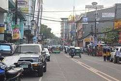
The Elias Angeles Street in Naga City | |
.svg.png) Metro Naga Map of the Philippines | |
| Coordinates: PH 13°37′N 123°10′E / 13.617°N 123.167°ECoordinates: PH 13°37′N 123°10′E / 13.617°N 123.167°E | |
| Country | Philippines |
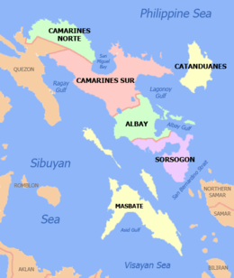
| Region | Bicol Region (Region V) |
| Province | Camarines Sur |
| Established | June 18, 1993 |
| Subdivisions | 15 LGU's (1 city, 14 municipalities) |
| Area[1] | |
| • Total | 1,258.54 km2 (485.93 sq mi) |
| Population (2010)[2] | |
| • Total | 741,925 |
| • Density | 590/km2 (1,500/sq mi) |
| Time zone | PST (UTC+8) |
| Website | Metro Naga Development Council |
Metro Naga is a metropolitan area in the Bicol Region of the Philippines, centering on the city of Naga and includes 14 neighboring municipalities of Camarines Sur province. The metropolitan area, which is managed by the Metro Naga Development Council, also includes Pili, the capital of the Camarines Sur, and covers most of the 2nd district of the province and part of its 1st, 3rd and 4th districts. Metro Naga comprise about 40% of the total population of the province, while covering 22.9% of the province in area.[1][3]
History
When there came a world oil crisis in 1991 as a result of the Gulf War, developmental planners in Naga and its surrounding municipalities had to rethink their goal and direction. They had to address more of their commonality rather than their diversity, resource sharing rather than politicking.
Inasmuch as almost all of the gasoline stations in Metro Naga are located in Naga, its then city mayor convened the mayors of the adjacent municipalities to map out their needs and priorities in setting the system and procedure for rationing available fuel supply. The resulting scheme kept vital services running and its success paved the way for other cooperative efforts and undertakings – all leading to the creation of an institution – the Metro Naga Development Council—that would address these cross-boundary issues and problems.
Another impetus was the enactment of the Local Government Code (LGC) of 1991 which mandated the absorption of devolved personnel, creating chaos in the budgets of many Local government units (LGUs). Again, the mayors of Naga and its neighboring municipalities held informal meetings to share experiences and formulate common strategies to overcome the initial difficulties that accompanied the implementation of the LGC.
Then the senior citizens of the neighboring municipalities clamored that they also be granted the same benefits enjoyed by their colleagues in Naga. As early as 1989, Naga has in place a senior citizens program that granted the elderly various discounts from public institutions and private establishments. The mayors again met, "Metro Naga" was coined, and the Metro Naga Senior Citizens League was subsequently formed to facilitate the grant of discount privileges to Metro Naga elderly. This was the third event.
Soon after, requests for the use of the city's heavy equipment came from the municipal mayors bringing to the fore the need for a mechanism to facilitate such sharing of resources between the city and its neighbors. The new LGC gave the answer with its grant of expanded powers and prerogatives to LGUs allowing them to pool their efforts and resources for commonly beneficial projects and activities. A task force was formed to study the mechanics for the exercise of such powers. The rest, as they say, is history.
What was left was to forge a memorandum of agreement (MOA) formally detailing the covenants of roles and responsibilities of the different LGUs and have the MOA approved by their respective legislative councils. This MOA was signed on April 23, 1993 in Naga with then Secretary Rafael Alunan III of the Department of Interior and Local Government as principal witness.
Thus was born the Metro Naga Development Council, a cooperative effort necessitated by the backlash of the Gulf War that later evolved into a partnership for the joint development of 15 LGUs. This local initiative was affirmed by then President Ramos himself through Executive Order No. 102 issued on June 18, 1993.[4]
Cities and municipalities
| Local government unit | Population (2015 census)[2] |
Area[1] (km²) | Income Classification[1] |
|---|---|---|---|
| Bombon | 16,512 | 28.73 | 4th class municipality |
| Bula | 69,430 | 167.64 | 1st class municipality |
| Calabanga | 83,033 | 163.80 | 1st class municipality |
| Camaligan | 24,109 | 4.68 | 4th class municipality |
| Canaman | 34,210 | 43.27 | 3rd class municipality |
| Gainza | 11,262 | 14.75 | 5th class municipality |
| Magarao | 25,694 | 44.97 | 4th class municipality |
| Milaor | 31,150 | 33.64 | 3rd class municipality |
| Minalabac | 52,390 | 126.10 | 3rd class municipality |
| Naga | 196,003 | 84.48 | 1st class city |
| Ocampo | 45,934 | 118.33 | 1st class municipality |
| Pamplona | 36,390 | 80.60 | 2nd class municipality |
| Pasacao | 49,035 | 149.54 | 1st class municipality |
| Pili (provincial capital) | 89,545 | 126.25 | 1st class municipality |
| San Fernando | 35,258 | 71.76 | 2nd class municipality |
Transportation
Metro Naga is very accessible by air, road and rail transport making the location an easy getaway destination. Philippine Airlines and Cebu Pacific fly twice daily each between Manila and Naga with a flight time of only 50 minutes.
By road, the area is connected with Manila by the new Andaya Highway reducing travel time to only 6 hours and daily rail services to and from Manila are provided by the Philippine National Railways.
Metro Naga transport facilities provide as major gateways to Metro Manila, in the north, and to Metro Cebu, in the south. A fleet replacement incentive program for bus operators likewise modernized the buses serving the Bicol-Manila route. Combined, these enhanced the integration of Metro Naga's economy with the rest of the country.[5]
Power supply
Assuring the growth of Metro Naga's economy is the adequate supply of electricity. At present, four electric cooperatives combine to supply the area with stable power from the national grid.
The four electric utility firms operating in Metro Naga provide the area with a combined rated capacity of 55 MVA and are still expanding their networks by tapping into other renewable and cost-efficient sources of energy.[6]
Water supply
Metro Naga's lush forests are the main sources of potable water in the area. The major water utility firm in the area, the Metropolitan Naga Water District (MNWD), gets its water mainly from the three springs of Mount Isarog. Likewise, several mineral water bottling companies source their water from this mountain.
MNWD has a combined capacity of 1048.5 liters per second, while household demand is currently pegged at 465 liters per second. Other springs and groundwater are also tapped to supply the increasing demand for potable water for Metro Naga's industries and increasing population.[7]
Communication facilities
Metro Naga has the most up-to-date telecommunication facilities. BayanTel and Digitel, the two major telephone companies in the country, have over 138,000 subscribers in the metro area, while three major cellphone companies - Smart Communications, Globe Telecom and Sun Cellular - offer wireless communication and Short Message Service (SMS).
Broadband internet access is widely available through the DSL facilities of the landline telephone companies and the cable TV companies. These are complemented by at least eight Internet Service Providers (ISPs) and several internet cafes, which offer connections at affordable rates.[8]
Health services
Metro Naga has modern and well-equipped medical facilities. Naga alone has four secondary hospitals, one regional medical center and one infirmary. Aside from these, a district hospital is located in the municipality of Ocampo with a 24-hour emergency service. Furthermore, Metro Naga has over 800 private dental and medical clinics and excellent laboratory facilities.
Health care is of a high standard with experienced and well-trained medical practitioners and hospital support services.[9]
Literacy
Computer literacy in Metro Naga begins at an early age when for the first time most children are exposed to a variety of computer-based technologies. Aside from the availability of PCs in most schools, desktop computers and leisure games such as PlayStations are popular in many households. Internet use by households is increasing because of high telephone-to-household density and the affordability of connection costs.[10]
Recreation and leisure
The biodiversity of the landscape is a popular lure for the domestic and international adventure tourism markets. Eco-tourism locations, diving, mountain climbing and trekking, complemented with some of the Philippines' most famous historical landmarks including the Shrine of the Virgin of Peñafrancia and other Spanish architecture of archaeological importance. A number of resorts exist in and around Naga and local guest houses are found in the municipal towns of the surrounding areas.
Day and evening entertainment facilities are numerous and the availability of local artists offers unlimited opportunities for establishing jazz lounges and coffee bars.
There are opportunities to establish tourism niche market packages offering a wide variety of activities including hiking, scuba diving, bungee jumping and even fruit-picking in a rural environment.[11]
| Local government unit |
Development Role |
|---|---|
| Bombon | Primary food bowl; water resource development |
| Bula | Primary food bowl |
| Calabanga | Primary food bowl; fishing industry development |
| Camaligan | Auxiliary food supplier; gifts and home decors industry development |
| Canaman | Expansion area for middle-class housing |
| Gainza | Auxiliary food supplier; gifts and home decors industry development |
| Magarao | Primary food bowl |
| Milaor | Warehousing and bulk storage center |
| Minalabac | Auxiliary food supplier |
| Naga | Business, education and cultural center; base of operations for firms that want to tap the potentials of the regional markets |
| Ocampo | Primary food bowl |
| Pamplona | Industrial estate development; cattle and dairy industry development |
| Pasacao | Gateway to major markets through the Pasacao Port; cattle and dairy industry development; fishing industry development |
| Pili | Secondary trading center; agro-industrial development |
| San Fernando | Cattle and dairy industry development; water resource development |
References
- 1 2 3 4 "Camarines Sur - Municipalities and Cities". Philippine Statistics Coordination Board. Retrieved on 2012-05-15.
- 1 2 (2010-05-01). "Total Population by Province, City, Municipality and Barangay: as of May 1, 2010", pp. 30-62. National Statistics Office. Retrieved on 2014-01-29.
- ↑ "Pupolation Growth, by LGU". Metro Naga Development Council. Retrieved on 2012-05-15.
- ↑ "About Us - More". Metro Naga Development Council. Retrieved on 2012-05-15.
- ↑ "Transportation". Metro Naga Development Council. Retrieved on 2012-05-15.
- ↑ "Power Supply". Metro Naga Development Council. Retrieved on 2012-05-15.
- ↑ "Water Supply. Metro Naga Development Council. Retrieved on 2012-05-15.
- ↑ "Telecommunications". Metro Naga Development Council. Retrieved on 2012-05-15.
- ↑ "Health Services". Metro Naga Development Council. Retrieved on 2012-05-15.
- ↑ "Literacy". Metro Naga Development Council. Retrieved on 2012-05-15.
- ↑ "Recreation and Leisure". Metro Naga Development Council. Retrieved on 2012-05-15.
External links
Pili (capital) | |
| Municipalities | |
| Component city | |
| Independent component city |
|
| Administrative Divisions |
|  | ||||||
|---|---|---|---|---|---|---|---|---|
| Geography | ||||||||
| History | ||||||||
| Religion | ||||||||
| Public Utilities and Services |
| |||||||
| Transportation | ||||||||
| Education | ||||||||
| Landmarks |
| |||||||