Mildred, Kansas
| Mildred, Kansas | |
|---|---|
| City | |
 Location within Allen County and Kansas | |
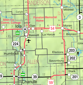 KDOT map of Allen County (legend) | |
| Coordinates: 38°1′22″N 95°10′25″W / 38.02278°N 95.17361°WCoordinates: 38°1′22″N 95°10′25″W / 38.02278°N 95.17361°W | |
| Country |
|
| State |
|
| County | Allen |
| Government | |
| • Type | Mayor–Council |
| Area[1] | |
| • Total | 0.21 sq mi (0.54 km2) |
| • Land | 0.21 sq mi (0.54 km2) |
| • Water | 0 sq mi (0 km2) |
| Elevation | 1,063 ft (324 m) |
| Population (2010)[2] | |
| • Total | 28 |
| • Estimate (2012[3]) | 28 |
| • Density | 130/sq mi (52/km2) |
| Time zone | Central (CST) (UTC-6) |
| • Summer (DST) | CDT (UTC-5) |
| FIPS code | 20-46500 [4] |
| GNIS feature ID | 0478129 [5] |
Mildred is a city in Allen County, Kansas, United States. As of the 2010 census, the city population was 28.[6]
History
Mildred was founded in 1907 when a cement plant was established there.[7] The city was named for the daughter of J. W. Wagner a local industrialist.[8][9] For much of the twentieth century, the city was served by the Missouri–Kansas–Texas Railroad, which maintained a passenger depot in the city, as well as spur lines that served the cement plant and the grain elevator.
Geography
Mildred is located at 38°1′22″N 95°10′25″W / 38.02278°N 95.17361°W (38.022777, -95.173512).[10] According to the United States Census Bureau, the city has a total area of 0.21 square miles (0.54 km2), all of it land.[1]
Demographics
| Historical population | |||
|---|---|---|---|
| Census | Pop. | %± | |
| 1920 | 336 | — | |
| 1930 | 341 | 1.5% | |
| 1940 | 155 | −54.5% | |
| 1950 | 79 | −49.0% | |
| 1960 | 60 | −24.1% | |
| 1970 | 42 | −30.0% | |
| 1980 | 64 | 52.4% | |
| 1990 | 46 | −28.1% | |
| 2000 | 36 | −21.7% | |
| 2010 | 28 | −22.2% | |
| Est. 2015 | 26 | [11] | −7.1% |
| U.S. Decennial Census | |||
2010 census
As of the census[2] of 2010, there were 28 people, 14 households, and 6 families residing in the city. The population density was 133.3 inhabitants per square mile (51.5/km2). There were 21 housing units at an average density of 100.0 per square mile (38.6/km2). The racial makeup of the city was 82.1% White, 10.7% African American, and 7.1% Native American. Hispanic or Latino of any race were 7.1% of the population.
There were 14 households of which 28.6% had children under the age of 18 living with them, 35.7% were married couples living together, 7.1% had a male householder with no wife present, and 57.1% were non-families. 57.1% of all households were made up of individuals and 21.4% had someone living alone who was 65 years of age or older. The average household size was 2.00 and the average family size was 3.33.
The median age in the city was 46 years. 25% of residents were under the age of 18; 3.4% were between the ages of 18 and 24; 14.3% were from 25 to 44; 39.3% were from 45 to 64; and 17.9% were 65 years of age or older. The gender makeup of the city was 57.1% male and 42.9% female.
2000 census
As of the census[4] of 2000, there were 36 people, 19 households, and 9 families residing in the city. The population density was 151.7 people per square mile (57.9/km²). There were 24 housing units at an average density of 101.1 per square mile (38.6/km²). The racial makeup of the city was 94.44% White, and 5.56% from two or more races.
There were 19 households out of which 21.1% had children under the age of 18 living with them, 26.3% were married couples living together, 10.5% had a female householder with no husband present, and 52.6% were non-families. 52.6% of all households were made up of individuals and 15.8% had someone living alone who was 65 years of age or older. The average household size was 1.89 and the average family size was 2.89.
In the city the population was spread out with 22.2% under the age of 18, 8.3% from 18 to 24, 27.8% from 25 to 44, 25.0% from 45 to 64, and 16.7% who were 65 years of age or older. The median age was 40 years. For every 100 females there were 111.8 males. For every 100 females age 18 and over, there were 115.4 males.
The median income for a household in the city was $21,250, and the median income for a family was $14,167. Males had a median income of $20,625 versus $11,250 for females. The per capita income for the city was $8,372. There were 16.7% of families and 15.6% of the population living below the poverty line, including 18.2% of under eighteens and none of those over 64.
References
- 1 2 "US Gazetteer files 2010". United States Census Bureau. Retrieved 2012-07-06.
- 1 2 "American FactFinder". United States Census Bureau. Retrieved 2012-07-06.
- ↑ "Population Estimates". United States Census Bureau. Retrieved 2013-05-29.
- 1 2 "American FactFinder". United States Census Bureau. Retrieved 2008-01-31.
- ↑ "US Board on Geographic Names". United States Geological Survey. 2007-10-25. Retrieved 2008-01-31.
- ↑ "2010 City Population and Housing Occupancy Status". U.S. Census Bureau. Retrieved April 6, 2011.
- ↑ "Mildred". Allen County. Retrieved 18 May 2014.
- ↑ Capace, Nancy (2000). Encyclopedia of Kansas. Somerset Publishers. p. 236.
- ↑ "Profile for Mildred, Kansas". ePodunk. Retrieved 29 June 2014.
- ↑ "US Gazetteer files: 2010, 2000, and 1990". United States Census Bureau. 2011-02-12. Retrieved 2011-04-23.
- ↑ "Annual Estimates of the Resident Population for Incorporated Places: April 1, 2010 to July 1, 2015". Retrieved July 2, 2016.
Further reading
- County
- Atlas and plat book of Allen County, Kansas; Kenyon Company; 90 pages; 1921.
- Plat book of Allen County, Kansas; North West Publishing Co. ; 33 pages; 1906.
External links
| Wikimedia Commons has media related to Mildred, Kansas. |
- City
- Schools
- USD 256, local school district
- Maps
- Mildred City Map, KDOT
Municipalities and communities of Allen County, Kansas, United States | ||
|---|---|---|
| Cities | 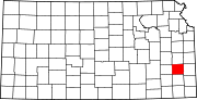 | |
| Unincorporated communities | ||
| Townships | ||