La Harpe, Kansas
| La Harpe, Kansas | |
|---|---|
| City | |
|
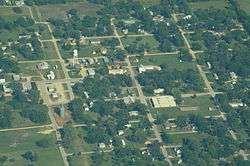
Aerial View of La Harpe (2013) | |
 Location within Allen County and Kansas | |
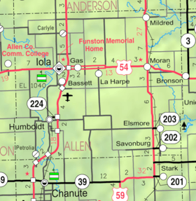 KDOT map of Allen County (legend) | |
| Coordinates: 37°54′56″N 95°17′59″W / 37.91556°N 95.29972°WCoordinates: 37°54′56″N 95°17′59″W / 37.91556°N 95.29972°W | |
| Country | United States |
| State | Kansas |
| County | Allen |
| Government | |
| • Type | Mayor–Council |
| Area[1] | |
| • Total | 0.82 sq mi (2.12 km2) |
| • Land | 0.82 sq mi (2.12 km2) |
| • Water | 0 sq mi (0 km2) |
| Elevation | 1,033 ft (315 m) |
| Population (2010)[2] | |
| • Total | 578 |
| • Estimate (2012[3]) | 576 |
| • Density | 700/sq mi (270/km2) |
| Time zone | Central (CST) (UTC-6) |
| • Summer (DST) | CDT (UTC-5) |
| ZIP code | 66751 |
| Area code(s) | 620 |
| FIPS code | 20-37725 [4] |
| GNIS feature ID | 0474511 [5] |
La Harpe is a city in Allen County, Kansas, United States.[6] As of the 2010 census, the city population was 578.[7]
History
La Harpe was founded by the Fort Scott, Wichita & Western Railroad company (later the Missouri Pacific), and was platted in 1881.[8] It was named after La Harpe, Illinois.[9]
When natural gas was discovered in the immediate vicinity in 1899 the city began to grow more rapidly and soon rose to be a city of importance. It was incorporated as a city of the second class, and in 1910 had some of the largest zinc smelters in the world, two banks, an opera house, several good mercantile establishments, a newspaper, and all the municipal improvements usually found in cities of that class. The population that year was 2,080. Its post office, first opened in November 1881,[10] was authorized to issue international money orders, and two rural routes supplied mail to the surrounding country.[11]
Geography
La Harpe is located at 37°54′56″N 95°17′59″W / 37.91556°N 95.29972°W (37.915631, -95.299729).[12] Situated along U.S. Route 54 in the central part of Allen County, La Harpe is about 5½ miles east of the city of Iola (the county seat), 2½ miles east of Gas, and about seven miles west of the junction of U.S. Routes 54 and 59 and the city of Moran.
According to the United States Census Bureau, the city has a total area of 0.82 square miles (2.12 km2), all of it land.[1]
Demographics
| Historical population | |||
|---|---|---|---|
| Census | Pop. | %± | |
| 1900 | 610 | — | |
| 1910 | 2,080 | 241.0% | |
| 1920 | 1,001 | −51.9% | |
| 1930 | 756 | −24.5% | |
| 1940 | 624 | −17.5% | |
| 1950 | 511 | −18.1% | |
| 1960 | 529 | 3.5% | |
| 1970 | 509 | −3.8% | |
| 1980 | 687 | 35.0% | |
| 1990 | 650 | −5.4% | |
| 2000 | 706 | 8.6% | |
| 2010 | 578 | −18.1% | |
| Est. 2015 | 543 | [13] | −6.1% |
| U.S. Decennial Census | |||
2010 census
As of the census[2] of 2010, there were 578 people, 234 households, and 161 families residing in the city. The population density was 704.9 inhabitants per square mile (272.2/km2). There were 273 housing units at an average density of 332.9 per square mile (128.5/km2). The racial makeup of the city was 93.6% White, 1.4% African American, 1.2% Native American, 0.9% Asian, 1.0% from other races, and 1.9% from two or more races. Hispanic or Latino of any race were 1.6% of the population.
There were 234 households of which 28.6% had children under the age of 18 living with them, 49.6% were married couples living together, 12.0% had a female householder with no husband present, 7.3% had a male householder with no wife present, and 31.2% were non-families. 26.1% of all households were made up of individuals and 12% had someone living alone who was 65 years of age or older. The average household size was 2.47 and the average family size was 2.91.
The median age in the city was 42.2 years. 22.3% of residents were under the age of 18; 9% were between the ages of 18 and 24; 24.1% were from 25 to 44; 27.9% were from 45 to 64; and 16.8% were 65 years of age or older. The gender makeup of the city was 52.1% male and 47.9% female.
2000 census
As of the census[4] of 2000, there were 706 people, 268 households, and 191 families residing in the city. The population density was 819.4 people per square mile (317.0/km²). There were 298 housing units at an average density of 345.9 per square mile (133.8/km²). The racial makeup of the city was 93.77% White, 0.99% African American, 2.12% Native American, and 3.12% from two or more races. Hispanic or Latino of any race were 0.85% of the population.
There were 268 households out of which 35.8% had children under the age of 18 living with them, 57.1% were married couples living together, 9.7% had a female householder with no husband present, and 28.4% were non-families. 23.5% of all households were made up of individuals and 11.2% had someone living alone who was 65 years of age or older. The average household size was 2.63 and the average family size was 3.08.
In the city the population was spread out with 28.6% under the age of 18, 9.8% from 18 to 24, 29.6% from 25 to 44, 21.4% from 45 to 64, and 10.6% who were 65 years of age or older. The median age was 34 years. For every 100 females there were 103.5 males. For every 100 females age 18 and over, there were 100.8 males.
The median income for a household in the city was $24,219, and the median income for a family was $32,981. Males had a median income of $22,102 versus $16,058 for females. The per capita income for the city was $12,196. About 8.9% of families and 13.4% of the population were below the poverty line, including 16.1% of those under age 18 and 11.8% of those age 65 or over.
Notable people
- Ad Brennan, baseball player
References
- 1 2 "US Gazetteer files 2010". United States Census Bureau. Retrieved 2012-07-06.
- 1 2 "American FactFinder". United States Census Bureau. Retrieved 2012-07-06.
- ↑ "Population Estimates". United States Census Bureau. Retrieved 2013-05-29.
- 1 2 "American FactFinder". United States Census Bureau. Retrieved 2008-01-31.
- ↑ "US Board on Geographic Names". United States Geological Survey. 2007-10-25. Retrieved 2008-01-31.
- ↑ "Geographic Names Information System". United States Geological Survey. Retrieved 2008-01-31.
- ↑ "2010 City Population and Housing Occupancy Status". U.S. Census Bureau. Retrieved April 6, 2011.
- ↑ "La Harpe". Allen County. Retrieved 18 May 2014.
- ↑ "Profile for La Harpe, Kansas". ePodunk. Retrieved 29 June 2014.
- ↑ "Kansas Post Offices Database". Kansas State Historical Society. Retrieved 2007-12-15. Containing information taken from Baughman, Robert W. Kansas Post Offices, May 29, 1828–August 3, 1961. Kansas Postal History Society.
- ↑ Frank W. Blackmar, ed. (1912). "La Harpe". Kansas: a cyclopedia of state history, embracing events, institutions, industries, counties, cities, towns, prominent persons, etc ... II. Chicago: Standard Pub Co. p. 92. Retrieved 2007-12-15.
- ↑ "US Gazetteer files: 2010, 2000, and 1990". United States Census Bureau. 2011-02-12. Retrieved 2011-04-23.
- ↑ "Annual Estimates of the Resident Population for Incorporated Places: April 1, 2010 to July 1, 2015". Retrieved July 2, 2016.
Further reading
- County
- Atlas and plat book of Allen County, Kansas; Kenyon Company; 90 pages; 1921.
- Plat book of Allen County, Kansas; North West Publishing Co. ; 33 pages; 1906.
External links
| Wikimedia Commons has media related to La Harpe, Kansas. |
- City
- Schools
- USD 257, local school district
- Maps
- La Harpe City Map, KDOT
Municipalities and communities of Allen County, Kansas, United States | ||
|---|---|---|
| Cities | 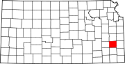 | |
| Unincorporated communities | ||
| Townships | ||