Morrissey Boulevard
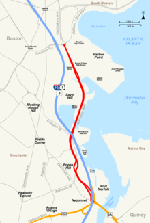 Morrissey Boulevard highlighted in red | |
| Maintained by | the Department of Conservation and Recreation |
|---|---|
| Length | 2.71 mi[1] (4.36 km) |
| From |
|
| To | Kosciuszko Circle |
Morrissey Boulevard is a six-lane divided coastal road in the Dorchester neighborhood of Boston, Massachusetts. It is owned and maintained by the Massachusetts Department of Conservation and Recreation (DCR).
Route description
A parkway, Morrissey Boulevard leaves Neponset Circle at its northeast quadrant as the left two lanes of a three lane exit, with the rightmost lane splitting to the east as an entrance ramp to the Southeast Expressway (Interstate 93). Traveling under the expressway within a landscaped park area fronting the DCR-operated Devine Memorial ice rink,[2] the road then travels north through the Neponset and Popes Hill sections of Dorchester with commercial establishments on both sides. The road splits as it passes under the tracks of the MBTA Red Line rapid transit route at what was previously Popes Hill Station of the Old Colony Railroad.[3][4] A Dunkin' Donuts store now occupies the area between the two roadways. The entrance to Tenean Beach, part of the DCR's Dorchester Shores Reservation, is located off the right roadway in this section.[5]
Morrissey Boulevard proceeds north past the Richard J. Murphy Elementary School and is flanked by heavy commercial development over the following 0.5 miles (0.80 km) to Freeport Street. At Freeport, the road again passes beneath the expressway and travels to the east of it from that point to the end of the boulevard. As a northbound exit ramp from the expressway enters on the right, the view east is dominated by a 140-foot (43 m) LNG storage tank which is painted with Rainbow Swash, an iconic work by Corita Kent that has made the gas tank a Boston landmark.[6] The parkway passes over the inlet from Dorchester Bay to Savin Hill Bay carried by the John J. Beades Memorial Bridge, a drawbridge which opens to allow passage to Dorchester Yacht Club.[7] Savin Hill Beach, Malibu Beach, Savin Hill Yacht Club and the Vietnam Veterans Memorial of Dorchester are located along Morrissey Boulevard in this area adjacent to Savin Hill and featured as part of Boston Harborwalk.[8]
The University of Massachusetts Boston, Boston College High School, John F. Kennedy Presidential Library and Museum and The Boston Globe are among the institutions located on Morrissey Boulevard in its northernmost stretch beyond Savin Hill. The road ends as it intersects Columbia Road and Day Boulevard at Kosciuszko Circle, adjacent to the Harbor Point section of Dorchester and JFK/UMass subway and commuter rail station.[9]
History
The road was designed as early as 1906 as an urban parkway to be constructed along the route of the Old Colony Railroad to give travelers to Quincy and Massachusetts South Shore locations a way to bypass city streets.[10] In planning for nearly two decades, it was finally completed in 1924 and named Old Colony Parkway.[11] The originally proposed route paralleling the railroad was changed and moved to the shore of Dorchester Bay on the Atlantic Ocean due in part to land reclamation efforts prior to completion of the road. Old Colony Parkway was renamed William T. Morrissey Boulevard in 1951 in honor of the former head of the Metropolitan District Commission, now the Massachusetts Department of Conservation and Recreation (DCR).[11] The older commission constructed many parkways within Greater Boston and the DCR continues to own and maintain Morrissey Boulevard.[10]
References
- ↑ Executive Office of Transportation, Office of Transportation Planning - 2007 Road Inventory
- ↑ "DCR Skating Rinks". Commonwealth of Massachusetts. Retrieved 1 January 2011.
- ↑ O'Regan, Gerry. "MBTA Red Line". nycsubway.org. Retrieved 1 January 2011.
- ↑ Cassani, Janice. "Pope's Hill". Dorchester Atheneum. Retrieved 1 January 2011.
- ↑ "Dorchester Shores Reservation". Commonwealth of Massachusetts. Retrieved 1 January 2011.
- ↑ "Wartime Visions". National Public Radio. Retrieved 1 January 2011.
- ↑ Forry, Bill (June 4, 2003). "State Officials: Morrissey Drawbridge Work to End by Late Summer". Dorchester Reporter. Retrieved 1 January 2011.
- ↑ "Dorchester: Malibu Beach / Savin Hill Beach". Places to go. The Boston Harbor Association. Retrieved 1 January 2011.
- ↑ "JFK/UMass Statiom". MBTA. Retrieved 1 January 2011.
- 1 2 Seasholes, Nancy S. (2003). Gaining Ground: A History of Landmaking in Boston. Boston: MIT Press. p. 342. ISBN 978-0-262-19494-5. OCLC 51810749. Retrieved 2009-10-31.
- 1 2 Vrabel, Jim (2004). When in Boston: A Time Line and Almanac. Boston: Northeastern University Press. p. 277. ISBN 978-1-55553-621-3. OCLC 54759462. Retrieved 2009-10-31.
External links
- Map of the route
- The Norman B. Leventhal Map Center at the Boston Public Library 1926 Boston street map published by the Boston City Planning Board
Coordinates: 42°18′2.5″N 71°2′57.6″W / 42.300694°N 71.049333°W