Mount San Antonio
| Mount San Antonio | |
|---|---|
%2C_California.jpg) Aerial view of Mt. San Antonio, facing north. | |
| Highest point | |
| Elevation | 10,064 ft (3,068 m) NAVD 88[1] |
| Prominence | 6,224 ft (1,897 m) ↓ Cajon Pass [1] |
| Isolation | 42.52 mi (68.43 km) → San Bernardino Peak |
| Listing | |
| Coordinates | 34°17′20″N 117°38′48″W / 34.2888927°N 117.6467218°WCoordinates: 34°17′20″N 117°38′48″W / 34.2888927°N 117.6467218°W [3] |
| Geography | |
 Mount San Antonio  Mount San Antonio Location in California | |
| Location | Los Angeles / San Bernardino counties, California U.S. |
| Parent range | San Gabriel Mountains |
| Topo map | USGS Mount San Antonio |
| Geology | |
| Mountain type | Granitic |
| Climbing | |
| Easiest route | Ski lift to Baldy Notch, Devil's Backbone Trail (hike) |
Mount San Antonio, colloquially referred to as Mount Baldy, is the highest peak of the San Gabriel Mountains, and the highest point in Los Angeles County, California. The peak is within the San Gabriel Mountains National Monument and Angeles National Forest.
Mount San Antonio's sometimes snow-capped peaks are visible on clear days and dominate the view of the Los Angeles Basin skyline.
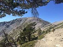
The peak is pyramid shaped, with a steep south face (Baldy Bowl) and a shallower north face. The summit is accessible via a number of connecting ridges along hiking trails from the north, east, south and southwest.
Name
The mountain is almost always referred to as "Mount Baldy" by locals, to the point where many would not recognize the name "Mount San Antonio".
The mountain was named by a local rancher after Saint Anthony of Padua. When American settlers arrived and surveyed the land, "Baldy", a reference to the bare fell-field of Baldy Bowl that dominates the south face visible from Los Angeles, became the predominant name, and it has stuck. Nonetheless, "Mount San Antonio" is the official name according to the GNIS, and is still used by a number of institutions (e.g. Mount San Antonio College).
Geography
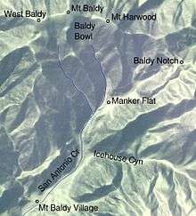
The summit has two peaks: the main peak, elevation 10,064 feet (3,068 m), and a sub-peak, West Baldy, at 9,988 feet (3,044 m).[4] The main peak marks the boundary between San Bernardino County and Los Angeles County.[5] The mountain is in the Angeles National Forest.
The mountain's southern watershed drains into San Antonio Creek, the north side into Lytle Creek and the Fish Fork of the San Gabriel River. San Antonio and Lytle Creeks are part of the Santa Ana River watershed. San Antonio Creek descends through a deep canyon which has several waterfalls, the last about 75 feet (23 m) high.[6]
East of the summit is Mount Harwood, which is in turn connected by a narrow ridge, "The Devil's Backbone," to a pass known as the Baldy Notch. At the Notch there is a ski resort, the closest one to Los Angeles. South of the resort, and connected to its ski lift by an asphalt road, lies Mt Baldy Village.
There are no roads or maintained trails connecting the mountain to the less populated region to its north, but a use trail leads over Dawson and Pine Mountains to Wright Mountain and the Pacific Crest Trail, overlooking the town of Wrightwood.
Natural history
Geology
Mount San Antonio lies in the front range of the San Gabriel Mountains, one of the Transverse Ranges of Southern California, formed around the San Andreas Fault system. The Transverse Ranges were formed because of a dog-leg bend in the San Andreas, which is a transform fault. The bend makes it difficult for the two plates to move smoothly past one another, and mountains were raised as a result.
The prehistoric Hog Back landslide lies in the canyon of San Antonio Creek at 4000' elevation. When the slide occurred, it dammed the river, whose depth built up until the water was released catastrophically, forming a slot canyon which now holds some of the area's few good rock climbing routes (difficulty 5.11, sport).
In modern times, notable floods have occurred in 1938 and 1969. The San Antonio Dam was completed in 1956, after a pause due to World War II, in an effort to prevent future floods as severe as the one in 1938, which damaged the low-elevation, highly populated areas below. The dam succeeded in significantly reducing the damage done by the 1969 flood. Hydroelectric plants along San Antonio Creek are tied to the electric grid.

Plants
The lower land area of the mountain consists of an ecological community known as yellow pine forest.[7] Tree species include lodgepole pine, Jeffrey pine (also known as western yellow pine), white fir, and some sugar pine.[8] Limber pine occurs at the higher elevations.[9] These forests are fairly sparse, and are intermixed with chaparral and oak savannah.
Higher up, the yellow pine forest community gives way to a pure lodgepole forest. Near 9000 ft (2750 m) these become increasingly krummholzed, and beyond about 9500 ft (2900 m) lies an unforested subalpine zone.
The dominant shrubs at the higher elevations are manzanita and bush chinquapin As the elevation increases, there is a higher ratio of chinquapin to manzanita. Other shrubs on the mountain include mountain whitethorn, buckwheat, and mountain gooseberry.
Wildflower species include Galium parishii, San Gabriel alumroot, gray monardella, pumice alpinegold, Parry's pussypaws, Nuttall's sandwort, and caulanthus. There are also Ross's sedge and rockcress. Oreonana vestita, a type of mountainparsley, is adapted to talus.[10]
Animals
Desert bighorn sheep (Ovis canadensis nelsoni) are found in the area, mostly above 7000', and they lamb in the area.[11] Their population is less threatened than those of other subspecies in California. Unlike animals of this subspecies in the Mojave Desert, those in the San Gabriel Mountains cannot be legally hunted and need not compete with aggressive feral burros for food or water.[12]
.jpg)
Grizzly bears, featured on the state flag, were once common in the Transverse Ranges, but were driven to extinction in California in the late 19th century, with one of the last animals in the San Gabriels being shot in 1894 by Walter L. Richardson. Black bears did not naturally exist in the San Gabriel Mountains, but in 1933 eleven black bears from Yosemite Valley that had shown problematic behavior were moved to Southern California and released near Crystal Lake.[11] All black bears in the San Gabriels are believed to be descended from this group. Black bears are relatively shy and are almost never known to harm humans.
Rabbits and coyotes are found near San Antonio Creek at low elevations, typically below 2000'. The most common species of rabbits are the black-tailed jackrabbit (Lepus californicus) and the desert cottontail (Sylvilagus audubonii),[13] the jackrabbit being distinguished by its huge ears. Western gray squirrels live in oak forests at low elevations, on both the south side and the desert side of the range.[11] Merriam's chipmunk (Tamias merriami) inhabits the San Gabriels in low-elevation areas containing manzanita, below the yellow pine forest community.
Rodents found at higher elevations in the San Gabriels include lodgepole chipmunks (Tamias speciosus), all the way up to the tree line,[11] and the California ground squirrel (Otospermophilus beecheyi) in the yellow pine forest on the south side of the range. They hibernate in winter. Rabbits may also occasionally be observed at high elevations.[11]
The two species of chipmunk are difficult to distinguish visually, and firm identification may require examination of their pubic bones, but the Lodgepole chipmunk has brighter white stripes.[14] It is easier to distinguish the western gray squirrel (gray, with a white belly and a big, bushy tail) from the California ground squirrel, which is spotted and has a gray area on the back of its neck.
Recreation
Hiking trails reach the summit from four sides of the mountain,[15] and one route can be completed with assistance from the nearby ski lift.[16]

For mountaineers, the winter and spring offer a snow climbing challenge. The "Baldy Bowl" south of the summit is often climbed with crampons and ice ax, depending on snow conditions. The bowl can be treacherous for inexperienced climbers as some sections have slopes of 45° to 50°. Avalanches and rock fall are both hazards. There are also a number of summer routes to the summit involving cross-country travel or scrambling,[17] and it is possible to rappel down the canyon of San Antonio Creek.[18]
For road cyclists the climb through Mt. Baldy Village to the base of the ski lifts is popular. It has been used as the finish of the penultimate stage of the 2011 and 2012 Amgen Tour of California.
Since 1965, each Labor Day, the San Antonio Canyon Town Hall has sponsored a "Run to the Top" on Mt. Baldy in which a 8-mile (13 km) course over roads and trails ends at the 10,064-foot (3,068 m) summit for a 4,000-foot (1,200 m) elevation gain.[19]
Dogs are legal in Angeles National Forest, but must be on a leash. Hunting is allowed, but is regulated and requires a license.[20]
History
Exploitation of resources
The Tongva tribe call the mountain Yoát or Joat, which means snow, and the Mohave call it Avii Kwatiinyam.[21] The name Mount San Antonio was probably bestowed by Antonio Maria Lugo, owner of a rancho near present-day Compton, ca. 1840, in honor of his patron saint Anthony of Padua.[22]
The first development in the area came in the Civil War era, and was focused on exploitation of the area's resources both by independent homesteaders and for use by the populated lowland areas. Some of the first people to live permanently in the area were Mormon settlers in Lytle Creek Canyon (1851), orange farmer Madison Kincaid (1865) and fruit farmer and beekeper A.A. Dexter (ca. 1875).[23] A sawmill was built in 1870 upstream from today's Mt. Baldy Village, but it either burned down or was destroyed in the flood of 1884.[24]
Ever since 1882, the San Antonio Water Company has controlled the water rights in San Antonio Canyon, including its three hydroelectric plants.
A tributary of San Antonio Creek flows through what is now known as Icehouse Canyon. Because the canyon is deep, its north-facing slope retains snow late into the spring, and in 1859 Victor Beaudry and Damien Marchessault built an icehouse there. The ice was brought down from the mountains to Los Angeles by mule and wagon and sold door to door, as well as being used at Beaudry and Marchessault's ice cream saloon, the only one in the city.[25][26][27] (Marchesseault was later mayor of Los Angeles.)
Gold mining did not begin in the area until decades after the California Gold Rush, with the earliest historical record being of the death of miner Jacob Skinner in 1879 in his mine at the Hog Back slide.[28] Placer mining gave way to hydraulic mining in the 1880s and continued through the 90's. The Banks (Hocumac) Mine was built in 1893 near the Baldy Notch. It was supplied with water by a mile-long pipeline, remnants of which can still be seen, running all the way from San Antonio Creek.[29][30] The remains of the Gold Ridge Diggings (a.k.a. Agamemnon mine) (1897-ca. 1904) are found near the headwaters of San Antonio Canyon, in the canyon below the Ski Hut.[31] The miners were kept supplied by sheep hunter turned merchant Fred Dell, who built Dell's Camp near the present Mt. Baldy Village, and by mule driver Fletcher Manker, who built a store at what is now known as Manker Flat. Gold mining began in Icehouse Canyon in 1892. The Hocumac and Gold Ridge mines were unsuccessful due to the uncertain water supply, the low amount of gold in the ore, and a water-pollution lawsuit filed by downslope farmers.[32]
Resort era

The late 19th century saw increased interest in the area for its own qualities and for recreation rather than for its resources. In 1875 an army surveying party made the first recorded ascent to the mountain's summit, via Lytle Creek, and estimated the height of the peak.[33] In 1880, W.H. Stoddard, brother-in-law of railroad baron Collis P. Huntington, built a resort in what is now called Stoddard Canyon. Frank Keyes converted Dell's Camp from a mining support station into a rental resort. Early mountain guide William B. Dewey led parties of guests to the summit on a loop corresponding to the present-day Mt. Baldy Trail and Devil's Backbone Trail. Rental cabins were also built in Evey Canyon. Access to the upper canyon was impeded by the precarious nature of the trail going over the Hog Back slide, but by the turn of the century Dell's Camp nevertheless entertained as many as a hundred guests in a weekend.
Charles Baynham built a second camp nearby in 1907, and in the following year the canyon became accessible by automobile.[34] In 1910, Dewey built the Baldy Summit Inn, 80 feet below the mountaintop.[35] Despite the grand name, it consisted of only a set of tents and some storage buildings. It was damaged by a cooking fire in 1913 and never rebuilt.[22] By the early 1920s there were numerous trail camps and resorts such as the Icehouse Canyon Resort,[36] Bear Canyon Resort[37] Eleven Oaks,[38] Baynham Camp,[39] Alpine Woods,[40] Trail Inn,[41] Snow Crest,[42] and Kelly's Camp.[43]
The shift from exploitation of natural resources to recreational use of San Antonio Canyon resulted in a series of bitter conflicts between the San Antonio Water Company and the camp owners. Pollution of the watershed and an 1899 brush fire led the company to buy Dell's Camp and close it, wrest legal control of the road away from Baynham, close off the canyon with locked gates, and station armed guards to keep out intruders. But after some time and various legal battles, the company decided to profit from recreation rather than discouraging it. It bought Baynham's Camp in 1907 but then hired Baynham to manage it, charging tolls on the road from 1908 to 1922. The camp was renamed Camp Baldy in 1910.
When the area became a national forest in 1908, the forest service began offering 99-year leases of plots of land in Icehouse Canyon for vacation cabins. By 1938 there were 105 cabins and additional cabins at a resort owned by the Chapman family. Leases were also sold, both by the government and by the water company, at Camp Baldy and Manker Flat.
Between 1922 and 1927 American physicist Albert A. Michelson performed a number of experiments involving bouncing a beam of light off a reflector at Lookout Mountain,[44] a prominence 3.2 miles (5.1 km) southwest of the peak, from the observatory at Mount Wilson some 22 miles (35 km) away. The distance was accurately measured with state-of-the-art surveying techniques,[45] and the speed of light calculated to be 299,796±4 km/s.[46] The concrete piers on Lookout Mountain still exist.[47]

Prohibition
During Prohibition, the area became known as a place where one could get a drink away from the watchful eyes of the police.[48] Former Yosemite concessionaire Foster Curry, his wife Ruth Curry, and Ruth's second husband, movie star Edmund Burns, turned Camp Baldy into a playground for affluent residents of Los Angeles, with a swimming pool, casino, and a dance pavilion.[49][50]
In 1935–1936 the Civilian Conservation Corps built a wide trail along the Devil's Backbone from Mt. Baldy Notch to the summit, a route which had previously been a narrow and dangerous due to the precipitous drops on one, or in some areas both, sides.[51]
Aurelia Harwood, the first female president of the Sierra Club, was active in the area. Mount Harwood, a subsidiary peak of Mount Baldy, is named for her. The Sierra Club built a lodge, also named after her, at Manker Flats in 1930. It is open to Sierra Club members. In 1935 the club added a mountain hut, known as the "ski hut," by the base of the Baldy Bowl near the headwaters of San Antonio Creek. The ski hut burned down that year but was immediately replaced and remains standing today.
After the 1938 flood
The flood of 1938 destroyed most of the manmade structures in Camp Baldy and Icehouse Canyon. The casino was destroyed, but the hotel (today's Buckhorn Lodge) survived. No new building has been allowed in Icehouse Canyon, and the Icehouse Canyon resort was destroyed in 1988 by a suspicious fire.[52] Camp Baldy was rebuilt and later became Mt. Baldy Village. The ski lift dates to 1952 and was expanded and modernized in 1975.[22] As the surviving privately owned cabins in Icehouse Canyon, Baldy Village, and Manker Flats come to the end of their 99-year leases on their lots, the Forest Service, no longer wishing to be a landlord, is converting them to private ownership. A Zen Center was established at Manker Flats in 1971. As of 2014, the only resorts and lodges serving the general public are the Mt. Baldy Lodge[53] and Buckhorn Lodge in Mt. Baldy Village, and there is also a restaurant at the Baldy Notch ski area.
Today, Mt. Baldy Village has its own fire department,[54] church,[55] visitor's center[56] and school district. Mt. Baldy School (the abbreviation is the standard usage) has about 105 students.[57] The visitor center is tended by unpaid volunteer rangers. As of 2013, the Forest Service does not have any paid rangers on duty in the area.
 Looking Northwest at Baldy Summit from Baldy Bowl
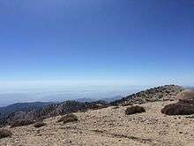 Looking Southwest from Mt. Baldy Summit
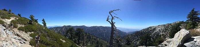 Panorama of LA just below Mt. Baldy summit
See also
- List of highest points in California by county
- List of Ultras of the United States
- Mt. Baldy Joint School District
- Mount Baldy Ski Lifts
- San Gabriel Mountains National Monument
References
- 1 2 "Mount San Antonio". Peakbagger.com. Retrieved 2009-01-25.
- ↑ "Hundred Peaks Section List". Angeles Chapter, Sierra Club. Retrieved 2016-08-10.
- ↑ "Mount San Antonio". Geographic Names Information System. United States Geological Survey. Retrieved 2016-08-10.
- ↑ "West Baldy, California". Peakbagger.com. Retrieved 2009-08-14.
- ↑ "Official Boundaries of the County of Los Angeles". Los Angeles Almanac. Retrieved 2008-08-30.
- ↑ "San Antonio Falls". Geographic Names Information System. United States Geological Survey. Retrieved 2009-08-14.
- ↑ Schoenherr, Allan A. (1992). A Natural History of California. University of California Press. ISBN 0-520-06922-6.
- ↑ Johnston, Verna R. California Forests and Woodlands: A Natural History. p. 158.
- ↑ Robinson, Trails of the Angels, p. 200
- ↑ "Mount San Antonio". BioHere. Retrieved 12 December 2014.
- 1 2 3 4 5 Vaughan, Mammals of the San Gabriel Mountains of California, 1954
- ↑ Schoenherr, A Natural History of California, pp. 216, 515
- ↑ Vaughan, Mammals of the San Gabriel Mountains of California, 1954
- ↑ Kays and Wilson, Mammals of North America
- ↑ "Dan's Hiking Pages: Introducing Mt. Baldy". Simpsoncity.com. Retrieved 12 December 2014.
- ↑ "Scenic Chair Rides". Mtbaldy.com. Retrieved 2010-10-04.
- ↑ "Mount San Antonio (Mount Baldy)". Summitpost.org. Retrieved 12 December 2014.
- ↑ "San Antonio Falls (Mt. Baldy)". Canyonbeta.com. Retrieved 12 December 2014.
- ↑ "Mount Baldy Run to the Top". Run2top.com. Retrieved 12 December 2014.
- ↑ "Angeles National Forest - Hunting". Fs.usda.gov. Retrieved 12 December 2014.
- ↑ Munro, Pamela; Brown, Nellie; Crawford, Judith G. (1992). "A Mojave dictionary". UCLA occasional papers in linguistics. Los Angeles: University of California, Los Angeles. 10. OCLC 28561333.
- 1 2 3 Sierra Club Hundred Peaks Section, 100 Peaks Lookout newsletter, May 1969
- ↑ National Association of Geology Teachers, Field Trip Guidebook to San Antonio Canyon, Mount San Antonio, Cajon Pass, and Wrightwood Areas, Southern California (hereinafter NAGT), pp. 3–37
- ↑ Osborne, A guide to Mt. Baldy and San Antonio Canyon (hereinafter Osborne), p. 3
- ↑ John Robinson, Trails Of the Angels, p. 230
- ↑ "Explore Historic California September 2011". Explorehistoricalif.com. Retrieved 12 December 2014.
- ↑ John W. Robinson, Los Angeles in Civil War Days, 1860–1865, p. 19
- ↑ National Association of Geology Teachers, Field Trip Guidebook to San Antonio Canyon, Mount San Antonio, Cajon Pass, and Wrightwood Areas, Southern California, pp. 3–37
- ↑ Osborne, pp. 5, 62
- ↑ D.D. Trent, "Mount Baldy Mining Area," California Geology, Aug. 1986, p. 179, ftp://ftp.conservation.ca.gov/pub/dmg/pubs/cg/1986/39_08.pdf
- ↑ Trent
- ↑ Osborne, p. 62
- ↑ John W. Robinson, Trails of the Angels: 100 Hikes in the San Gabriels, p. 201
- ↑ Jerry Schad, Afoot and Afield Los Angeles County: A Comprehensive Hiking Guide
- ↑ Robinson, Trails of the Angels, p. 201
- ↑ opened 1919, Osborne, p. 68
- ↑ 1921, on the site of the present-day Mr. Baldy Lodge, Osborne, p. 57
- ↑ 1921, located behind the present-day fire station. Osborne, pp. 5, 56
- ↑ near today's trout pools
- ↑ 1930, below Icehouse Canyon; burned down in 1938
- ↑ 1927, a mile inside Icehouse Canyon
- ↑ near Manker Flat, closed and for sale ca. 2012
- ↑ north of Ontario Peak, now an undeveloped camping area for backpackers
- ↑ "Lookout Mountain". Geographic Names Information System. United States Geological Survey. Retrieved 2009-08-14.
- ↑ Garner, C. L., Captain (retired) (April 1949). "A Geodetic Measurement of Unusually High Accuracy" (PDF). U. S. Coast and Geodetic Survey Journal. Coast and Geodetic Survey: 68–74. Retrieved 2009-08-13.
- ↑ A.A. Michelson (1927). "Measurement of the Velocity of Light Between Mount Wilson and Mount San Antonio". Astrophysical Journal. Retrieved 12 December 2014.
- ↑ "The Mount Wilson-Mount San Antonio measurements (1922 – 1926)". Theotherhand.org. Retrieved 12 December 2014.
- ↑ Kimberly J. Creighton, Mt. Baldy, p. 55
- ↑ NAGT, pp. 3–38
- ↑ A few buildings remain, including the Buckhorn Lodge itself. The original casino burned down in 1936 and was replaced by the Wagon Wheel Casino a year later. The Wagon Wheel was across the street from the Buckhorn Lodge, with the dining room sticking out above the creek. A heated swimming pool adjoined the casino. The dance pavilion, picnic tables, and campsites were at the location of the present-day trout ponds. Osborne, pp. 13, 49
- ↑ Schad, 101 Hikes in Southern California, p. 82
- ↑ "Mt. Baldy History and Ice House Canyon « profmason.com". Profmason.com. Retrieved 12 December 2014.
- ↑ on the site of the former Bear Canyon Resort, Osborne, p. 57
- ↑ "Mt Baldy Fire Department". Mtbaldyfire.com. Retrieved 2012-12-30.
- ↑ "Welcome to Mt Baldy Village Church". Mtbaldyvillagechurch.com. Retrieved 2012-12-30.
- ↑ "Angeles National Forest Mt. Baldy Visitor Center". Fs.usda.gov. Retrieved 2012-12-30.
- ↑ "Mt Baldy School". Mt Baldy School District. Retrieved 2009-08-14.
External links
| Wikimedia Commons has media related to Mount San Antonio. |
- Mt. Baldy Visitor Center and Interpretive Site. Angeles National Forest.
- Mount San Antonio (Mount Baldy). SummitPost.org.
- Destruction at Camp Baldy after the 1938 flood. Flickr