Mount Horeb, Wisconsin
| Mount Horeb, Wisconsin | |
|---|---|
| Village | |
|
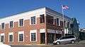
Mt. Horeb Opera Block on Main Street. | |
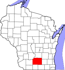
 Location in Dane County and the state of Wisconsin. | |
| Coordinates: 43°0′23″N 89°44′3″W / 43.00639°N 89.73417°WCoordinates: 43°0′23″N 89°44′3″W / 43.00639°N 89.73417°W | |
| Country | United States |
| State | Wisconsin |
| County | Dane |
| Area[1] | |
| • Total | 3.25 sq mi (8.42 km2) |
| • Land | 3.25 sq mi (8.42 km2) |
| • Water | 0 sq mi (0 km2) |
| Elevation[2] | 1,243 ft (379 m) |
| Population (2010)[3] | |
| • Total | 7,009 |
| • Estimate (2012[4]) | 7,294 |
| • Density | 2,156.6/sq mi (832.7/km2) |
| Time zone | Central (CST) (UTC-6) |
| • Summer (DST) | CDT (UTC-5) |
| Area code(s) | 608 |
| FIPS code | 55-54725[5] |
| GNIS feature ID | 1569817[2] |
| Website |
mounthorebwi |

Mount Horeb is a village in Dane County, Wisconsin, United States. The population was 7,009 at the 2010 census. It is part of the Madison Metropolitan Statistical Area.
History
A post office called Mount Horeb has been in operation since 1861.[6] The village was named after Mount Horeb, the mountain where Moses received the Ten Commandments, according to the Hebrew Bible.[7]
Geography
According to the United States Census Bureau, the village has a total area of 3.25 square miles (8.42 km2), all of it land.[1]
Demographics
| Historical population | |||
|---|---|---|---|
| Census | Pop. | %± | |
| 1880 | 42 | — | |
| 1900 | 864 | — | |
| 1910 | 1,048 | 21.3% | |
| 1920 | 1,350 | 28.8% | |
| 1930 | 1,425 | 5.6% | |
| 1940 | 1,610 | 13.0% | |
| 1950 | 1,716 | 6.6% | |
| 1960 | 1,991 | 16.0% | |
| 1970 | 2,402 | 20.6% | |
| 1980 | 3,251 | 35.3% | |
| 1990 | 4,182 | 28.6% | |
| 2000 | 5,860 | 40.1% | |
| 2010 | 7,009 | 19.6% | |
| Est. 2015 | 7,421 | [8] | 5.9% |
2010 census
As of the census[3] of 2010, there were 7,011 people, 2,696 households, and 1,878 families residing in the village. The population density was 2,156.6 inhabitants per square mile (832.7/km2). There were 2,826 housing units at an average density of 869.5 per square mile (335.7/km2). The racial makeup of the village was 96.0% White, 0.8% African American, 0.2% Native American, 0.6% Asian, 0.5% from other races, and 1.8% from two or more races. Hispanic or Latino of any race were 1.7% of the population.
There were 2,696 households of which 41.6% had children under the age of 18 living with them, 56.5% were married couples living together, 9.5% had a female householder with no husband present, 3.7% had a male householder with no wife present, and 30.3% were non-families. 24.4% of all households were made up of individuals and 10.2% had someone living alone who was 65 years of age or older. The average household size was 2.56 and the average family size was 3.09.
The median age in the village was 35.5 years. 29.5% of residents were under the age of 18; 5.8% were between the ages of 18 and 24; 29.1% were from 25 to 44; 24.1% were from 45 to 64; and 11.4% were 65 years of age or older. The gender makeup of the village was 47.9% male and 52.1% female.
2000 census
As of the census[5] of 2000, there were 5,860 people, 2,228 households, and 1,544 families residing in the village. As of 2010 there are 7,009 people. The population density (in 2000) was 2,011.5 people per square mile (777.5/km2). There were 2,305 housing units at an average density of 791.2 per square mile (305.8/km2). The racial makeup of the village was 98.28% White, 0.22% African American, 0.24% Native American, 0.31% Asian, 0.09% Pacific Islander, 0.34% from other races, and 0.53% from two or more races. Hispanic or Latino of any race were 0.58% of the population. 33.0% were of German, 22.6% Norwegian, 10.7% Irish, 5.8% English and 5.2% American ancestry according to Census 2000.
There were 2,228 households out of which 38.8% had children under the age of 18 living with them, 57.1% were married couples living together, 9.5% had a female householder with no husband present, and 30.7% were non-families. 24.3% of all households were made up of individuals and 10.5% had someone living alone who was 65 years of age or older. The average household size was 2.56 and the average family size was 3.07.
In the village the population was spread out with 28.8% under the age of 18, 6.8% from 18 to 24, 34.0% from 25 to 44, 17.4% from 45 to 64, and 13.0% who were 65 years of age or older. The median age was 34 years. For every 100 females there were 91.3 males. For every 100 females age 18 and over, there were 86.8 males.
The median income for a household in the village was $55,513, and the median income for a family was $63,234. Males had a median income of $40,850 versus $27,391 for females. The per capita income for the village was $23,359. About 0.8% of families and 3.1% of the population were below the poverty line, including 2.0% of those under age 18 and 9.0% of those age 65 or over.
Business and industry
Mount Horeb offers several good access points to the Military Ridge State Trail, a 39-mile (63 km) bicycle trail built on a former railroad right-of-way.
Mount Horeb was once home to the Mount Horeb Mustard Museum, a light-hearted museum with an approximately equal amount of floor space devoted to exhibits and to its museum store. The store has hundreds of varieties of mustard that can be sampled before purchase. The museum exhibits a large collection of unusual mustards and antique mustard jars. In 2002 the museum was showcased on the Food Network television series Unwrapped. The museum and its curator have also been featured on National Public Radio's Morning Edition broadcast of July 29, 2010,[10] and Weekend Edition Saturday on February 18, 1995.[11]
In 2009 the Mustard Museum relocated to Middleton, Wisconsin, where it is now known as the National Mustard Museum.
Mount Horeb has been known by some residents as the "Mustard Capital of the World" as well as the "Troll Capital of the World". The Chamber of Commerce calls the main street the "Trollway," and troll statues and themes decorate many area businesses. This reflects Mount Horeb's largely Norwegian heritage.
Mount Horeb is home to the Gonstead Clinic of Chiropractic, originally founded in 1939 by Dr. C.S. Gonstead. Gonstead developed the widely used Gonstead chiropractic technique for spinal adjustment.[12] With the completion in 1964 of a 19,000-square-foot (1,800 m2) building on Route 151, and the adjoining Karakahl Inn, it became a nationally recognized chiropractic center.[13] It gradually declined in importance after the 1978 death of its founder, and the buildings are currently deteriorating and the target of a preservation effort.[14]
Notable people
- Herman Dahle, member of the United States House of Representatives from Wisconsin
- Carl M. Grimstad, member of the Wisconsin State Assembly
- Edmund Hillestad, member of the South Dakota House of Representatives
- William C. Kahl, Wisconsin Superintendent of Public Instruction
- Clarence Gonstead, chiropractor at the Gonstead clinic
Images
 Post office
 Municipal building
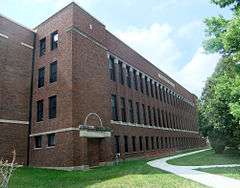 Mount Horeb Public School
 Henry L. and Sarah Dahle House
 Hoffs Department Store
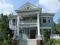 Herman B. and Anne Marie Dahle House
 Welcome sign
References
- 1 2 "US Gazetteer files 2010". United States Census Bureau. Retrieved 2012-11-18.
- 1 2 "US Board on Geographic Names". United States Geological Survey. 2007-10-25. Retrieved 2008-01-31.
- 1 2 "American FactFinder". United States Census Bureau. Retrieved 2012-11-18.
- ↑ "Population Estimates". United States Census Bureau. Retrieved 2013-06-24.
- 1 2 "American FactFinder". United States Census Bureau. Retrieved 2008-01-31.
- ↑ "Dane County". Jim Forte Postal History. Retrieved 1 March 2015.
- ↑ Chicago and North Western Railway Company (1908). A History of the Origin of the Place Names Connected with the Chicago & North Western and Chicago, St. Paul, Minneapolis & Omaha Railways. p. 105.
- ↑ "Annual Estimates of the Resident Population for Incorporated Places: April 1, 2010 to July 1, 2015". Retrieved July 2, 2016.
- ↑ "Census of Population and Housing". Census.gov. Retrieved June 4, 2015.
- ↑ Morning Edition story on the Mustard Museum
- ↑ Weekend Edition Saturday story on the Mustard Museum
- ↑ Carlson, Geri L. (2007). I Stand Amazed. Xulon Press. ISBN 1-60034-874-2., p. 145: "Chiropractic legend Dr. C. S. Gonstead"
- ↑ Koch, William H. (1995). Chiropractic: The Superior Alternative. Bayeux Arts. ISBN 1-896209-22-X., p. 138: "the world-famous Gonstead Chiropractic Clinic in Mt. Horeb, Wisconsin"
- ↑ Matthew J. Amman, DC (2007-09-20). "Preserving the Gonstead Clinic of Chiropractic - A Case of National Support". Gonstead Clinical Studies Society. Retrieved 2008-05-02.
External links
| Wikimedia Commons has media related to Mt. Horeb, Wisconsin. |
- Village of Mount Horeb
- Sanborn fire insurance maps: 1894 1905 1915