Muan County
| Muan 무안군 | ||
|---|---|---|
| County | ||
| Korean transcription(s) | ||
| • Hangul | 무안군 | |
| • Hanja | 務安郡 | |
| • Revised Romanization | Muan-gun | |
| • McCune-Reischauer | Muan-gun | |
|
| ||
| ||
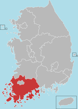
 Location in South Korea | ||
| Country |
| |
| Region | Honam | |
| Administrative divisions | 2 eup, 7 myeon | |
| Area | ||
| • Total | 436.4 km2 (168.5 sq mi) | |
| Population (December 2011) | ||
| • Total | 75,718 | |
| • Density | 173.50/km2 (449.4/sq mi) | |
| • Dialect | Jeolla | |
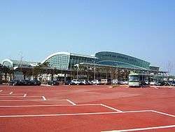
Muan County (Muan-gun) is a county in South Jeolla Province (Jeollanam-do), South Korea. In 2005, Muan County became the capital of Jeollanam-do following the transfer of the provincial office from its previous location, Gwangju to the village of Namak in Muan. Muan International Airport was opened here, and will eventually replace the airports in Gwangju and Mokpo.[1]
Modern history
On January 1 of 1963, several villages (ri in Korean) were incorporated into Mokpo city and huge reorganization was made by Korean government.[2] In 1979, Muan township was promoted to a township (eup of South Korea). In 1980, Illo was also promoted into a township.[3]
Symbols
- Flower : The Chrysanthemum
- Tree : The Zelkova tree
- Bird : The white Heron
Location
Muan County is located on the western tip of the South Western part of the Korean peninsula. It acts as the primary link between Sinan county with the rest of the Korean mainland. Numerous beaches are also found on Muan's coast.
Muan borders Yeongsan river with Naju and Hampyeong to the north, Yeongam to the east, Mokpo to the south. These surroundings have influenced the industrial and cultural structure of Muan County.[4]
Enterprise city
Muan was designated an enterprise city by the South Korean government for the Honam region (Southwest). The South Korean government and China have agreed to develop an industrial complex in a joint venture. It was reported that the Chinese government officially promised to invest in and help establish the complex area, which includes the construction of a college and distribution warehouses among other things such as a Chinatown for expatriates.[5]
Mud
Muan includes a large area of mudlands. The western area of the Korean peninsula has a large amount of mud thanks to the Rias coast. However, many mudlands have been destroyed or reclaimed for expanding city areas or industrial complexes.
The mudlands of Muan were designated one of the wetlands of the Ramsar Convention.
Festival
Muan is widely known for its White Lotus Festival (무안연꽃축제) located in Illo-eup.[6] The festival occurs in mid August when the white lotus flowers bloom fully onsite at the Hoesan White Lotus Pond (회산 백련지).[7] Tourists can walk into the huge lotuslands via the many bridges that crisscross the water. Visitors may also ride the 'duck boats.'
Products
Muan is known for several famous products characteristic of the area. They are largely farming goods from onions to lotus products. Muan puts out 16% of the national onion production making its production volume is the largest in Korea.[8]
Muan county officially reported to host farming cluster of sweet potato, onion and lotus plants. The powder of lotus plants is used for making noodles.
Education
Muan County is the site of Mokpo National University, situated in Cheonggye township.
Sister cities
-
 Uiryeong, South Gyeongsang, South Korea
 - Gunpo, Gyeonggi, South Korea
- Dobong-gu, Seoul, South Korea
-
 Taizhou, Zhejiang, China
 -
 Kitanagoya, Aichi, Japan[9]
 -
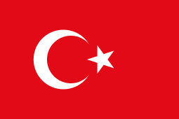 Denizli, Turkey[10][11]
References
- ↑ Welcome to muan-gun
- ↑ Alteration of the districts of boundaries including cities and counties(1962.11.21.)
- ↑ Regulation concerning establishment of 35 eup(towns). (1980. 10. 21.)
- ↑ Official page
- ↑ 무안기업도시 한중국제산단 민간자본금 증액 ‘개발 탄력’ 2008.01.11 http://www.fnnews.com/view?ra=Sent0501m_01A&corp=fnnews&arcid=0921202978&cDateYear=2008&cDateMonth=01&cDateDay=11&
- ↑ http://english.visitkorea.or.kr/enu/ATR/SI_EN_3_2_1.jsp?cid=293072. Missing or empty
|title=(help) - ↑ http://english.visitkorea.or.kr/enu/ATR/SI_EN_3_1_1_1.jsp?cid=1826865. Missing or empty
|title=(help) - ↑ Official page of Muan
- ↑ "International Exchange". List of Affiliation Partners within Prefectures. Council of Local Authorities for International Relations (CLAIR). Retrieved 21 November 2015.
- ↑ Denizli
- ↑ http://eng.denizli.bel.tr/
External links
| Wikivoyage has a travel guide for Muan. |
Coordinates: 34°59′23″N 126°28′17″E / 34.9897222222°N 126.471388889°E