Nash, Buckinghamshire
| Nash | |
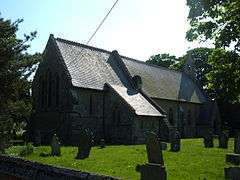 All Saints Church, in the village of Nash |
|
 Nash |
|
| Population | 417 (2011 census)[1] |
|---|---|
| OS grid reference | SP779343 |
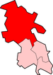
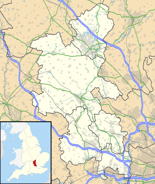
| Civil parish | Nash |
| District | Aylesbury Vale |
| Shire county | Buckinghamshire |
| Region | South East |
| Country | England |
| Sovereign state | United Kingdom |
| Post town | MILTON KEYNES |
| Postcode district | MK17 |
| Dialling code | 01908 |
| Police | Thames Valley |
| Fire | Buckinghamshire |
| Ambulance | South Central |
| EU Parliament | South East England |
| UK Parliament | Buckingham |
|
|
Coordinates: 52°00′12″N 0°51′59″W / 52.0034°N 0.8665°W
Nash is a village and also a civil parish within Aylesbury Vale district in Buckinghamshire, England. It is in the north of the county, about 5 miles (8.0 km) south west of Milton Keynes and 4 miles (6.4 km) miles east of Buckingham. In 2011, according to the census, the population total of Nash was 417.[1]
History
The village name is Anglo Saxon in origin, and means "at the ash-tree".[2] In the Domesday Book of 1086 the village was recorded as Esse. The name went through 'Ash' and 'La Nash' to 'Nash'.[3] Between 1870 and 1872, Nash was described as
"NASH, a hamlet in Whaddon parish, Bucks; 5½ miles E of Buckingham. Acres, 1, 430. Real property, £1, 813, Pop., 462. Houses, 103. The property is divided chiefly among five. The hamlet forms chief part of the chapelry of Thornton-cum-Nash; and contains the church of thatchapelry, a Baptist chapel, and a national school. Nash Common is a meet for the Whaddon Chase hounds."[4]
Nash was designated a civil parish between 1896 and 1899. Before this it was classed as a hamlet within the parish of Whaddon.[3]
Although there has never been a separate manor in Nash, the manor in neighbouring Whaddon has historically been referred to as the manor of Whaddon and Nash. The earliest mention of the manor pre-dates the modern name of 'Nash', and refers to the manor as that of 'Whaddone with Esse'.[3]
Government
The village is served by a parish council of seven members, who are elected every four years, with the next elections set to take place in 2019.[5] However much of the parish council's role is to advise the Aylesbury Vale District Council and Buckinghamshire County Council who make most of the decisions with regards to maintenance and planning.[5]
The village sits within the Great Marwood ward of the Aylesbury Vale District Council[6] and the local councillor has been Sir Beville Stanier Bt (Conservative) since 1999.[7] At the county level, the village is part of the Winslow electoral division[8] which is represented by John Chilver (Conservative).[9]
The local MP is John Bercow, MP for Buckingham[10] and Speaker of the House of Commons.[11]
Geography

The village is located 46 miles (75 km) north west of London[12] and is about 125 metres (410 ft) above sea level.[13]
According to the British Geological Survey, the bedrock consists of Mudstone with superficial deposits of sand and gravel from river terraces and glaciofluvia deposits.[14]
The first Land Utilisation Survey of Britain in the 1930s, found the land around Nash to be predominantly 'Meadowland and Permanent Grass', with some areas of 'Forest and Woodland'.[15]
Demography

The most recent, 2011, census of the UK put the total population of Nash at 417.[1] The population has grown sharply since the lowest recorded population total of 214, which was found in the 1961 census.[16] The population previously went through a long period of decline between 1871 (when the highest total population of 460 was recorded) and 1961.[17]
The ethnic composition of Nash is overwhelmingly white, with just 14 individuals identifying as being from other ethnic groups in the 2011 census.[18] Just over 60% of the population identify as Christian, whilst more than 37% either stated that they are not religious, or did not state their religion.[19]
The 2011 census also recorded that 43% of the population were in full-time employment, and 11.4% in part-time employment.[1] Just 2% of the population were identified as being unemployed, which is lower than the average for Aylesbury Vale (3.1%), and England (4.4%).[1]
Economy

Of the 212 members of the population in employment, the majority appear to commute to work, with some of the highest employing industries including 'Wholesale and Retail Trade; Repair of Motor Vehicles and Motor Cycles' (18.9%) and 'Manufacturing' (9.4%), neither of which take place within the village.[20] Other sectors with high levels of employment include 'Professional, Scientific and Technical Activities' (13.2%) and 'Education' (12.7%).[20]
This contrasts greatly from some of the traditional industries which were previously common in the village. In 1881, the main industries of the parish were agriculture (40% of the population), and textiles (31% of the population).[21]
Culture and community
Community facilities
After the village school closed in 1948, the building was converted into a community hall for the use of the villagers.[22] The hall is also available for hire, and is used to host several community events throughout the year, as well as the local youth club each week.[22]
Landmarks
The All Saints Church in Nash dates from 1857 when the foundation stone was laid.[3] It was based on designs by renowned architect George Edmund Street.[3]
Education
Nash has not had its own school since it closed in 1948.[22] It now sits within the catchement area of schools in local villages. For aged 4 to 7 this is Whaddon Church of England School, and for 7+ it is covered by Great Horwood Church of England School.[23]
References
- 1 2 3 4 5 "Nash: Key Figures for 2011 Census: Key Statistics". Neighborhood Statistics. Office for National Statistics. Retrieved 28 January 2016.
- ↑ "Key to English place-names". Key to English Place Names. University of Nottingham. Retrieved 10 March 2016.
- 1 2 3 4 5 "Parishes: Whaddon with Nash | British History Online". British History Online. British History Online. Retrieved 21 April 2016.
- ↑ Bartholomew, John (1887). Gazetteer of the British Isles (1st ed.). Edinburgh: Bartholomew.
- 1 2 "Parish Council". Nash Village Website. Nash Parish Council. Retrieved 6 March 2016.
- ↑ "Aylesbury Vale District Council – Find Councillor". Aylesbury Vale District Council. Aylesbury Vale District Council. Retrieved 6 March 2016.
- ↑ "Councillor details – Councillor Sir Beville Stanier Bt". Aylesbury Vale District Council. Aylesbury Vale District Council. Retrieved 6 March 2016.
- ↑ "Bucks County Council – Councillors". Bucks County Council. Esri (UK). Retrieved 6 March 2016.
- ↑ "Councillor details – John Chilver". Buckinghamshire County Council. Buckinghamshire County Council. Retrieved 6 March 2016.
- ↑ "MPs". UK Parliament. UK Parliament. Retrieved 6 March 2016.
- ↑ "Rt Hon John Bercow MP". UK Parliament. UK Parliament. Retrieved 6 March 2016.
- ↑ "Distance from London to Nash". distancefromto.net. distancefromto.net. Retrieved 6 March 2016.
- ↑ "Street map:Nash, Buckinghamshire". www.streetmap.co.uk. Streetmap EU. Retrieved 8 March 2016.
- ↑ "Geology of Britain viewer | British Geological Survey (BGS)". British Geological Survey. British Geological Survey. Retrieved 6 March 2016.
- ↑ "Old maps of Britain and Europe from 'A Vision of Britain Through Time'". A Vision of Britain through Time. GB Historical GIS / University of Portsmouth. Retrieved 23 April 2016.
- ↑ "Nash CP/Hmlt Population Statistics from A Vision of Britain through Time.". A Vision of Britain through Time. GB Historical GIS / University of Portsmouth. Retrieved 6 March 2016.
- ↑ "Census Data". Nash Village Website. Nash Parish Council. Retrieved 21 April 2016.
- ↑ "Ethnic Group, 2011". Neighbourhood Statistics. Office for National Statistics. Retrieved 23 April 2016.
- ↑ "Religion, 2011". Neighbourhood Statistics. Office for National Statistics. Retrieved 23 April 2016.
- 1 2 "Industry, 2011". Neighbourhood Statistics. Office for National Statistics.
- ↑ "1881 Occupational Orders". A Vision of Britain through Time. GB Historical GIS / University of Portsmouth. Retrieved 10 March 2016.
- 1 2 3 "Village Hall". Nash Village Website. Nash Parish Council. Retrieved 24 April 2016.
- ↑ "School Catchment Checker 2016". Bucks County Council. Esri (UK). Retrieved 24 April 2016.
External links
| Wikimedia Commons has media related to Nash, Buckinghamshire. |