National Register of Historic Places listings in Central Falls, Rhode Island
This is a list of Registered Historic Places in Central Falls, Rhode Island.
- This National Park Service list is complete through NPS recent listings posted December 2, 2016.[1]
| [2] |
Name on the Register[3] |
Image |
Date listed[4] |
Location |
City or town |
Description |
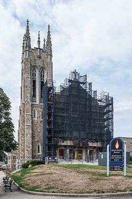
|---|
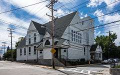
| 1 |
Central Falls Congregational Church |
|
000000001976-07-12-0000July 12, 1976
(#76000042) |
376 High St.
41°53′05″N 71°23′04″W / 41.884722°N 71.384444°W / 41.884722; -71.384444 (Central Falls Congregational Church) |
Central Falls |
|
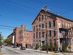
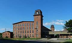
| 2 |
Central Falls Mill Historic District |
|
000000001976-07-02-0000July 2, 1976
(#76000007) |
Between Roosevelt Avenue and the Blackstone River
41°53′11″N 71°22′55″W / 41.886389°N 71.381944°W / 41.886389; -71.381944 (Central Falls Mill Historic District) |
Central Falls |
|
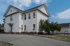
| 3 |
Central Street School |
|
000000001979-04-06-0000April 6, 1979
(#79000004) |
379 Central St.
41°53′04″N 71°23′38″W / 41.884444°N 71.393889°W / 41.884444; -71.393889 (Central Street School) |
Central Falls |
|
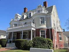
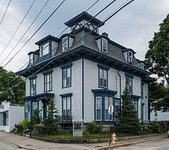
| 4 |
Samuel B. Conant House |
|
000000001979-04-06-0000April 6, 1979
(#79000005) |
104 Clay St.
41°52′59″N 71°23′25″W / 41.883056°N 71.390278°W / 41.883056; -71.390278 (Samuel B. Conant House) |
Central Falls |
|
| 5 |
Conant Thread-Coats & Clark Mill Complex District |
|
000000001983-11-18-0000November 18, 1983
(#83003809) |
Roughly bounded by Lonsdale Avenue, Rand and Pine Streets.
41°52′51″N 71°23′53″W / 41.880833°N 71.398056°W / 41.880833; -71.398056 (Conant Thread-Coats & Clark Mill Complex District) |
Central Falls |
Extends into Pawtucket
|
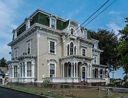
| 6 |
David G. Fales House |
|
000000001979-04-06-0000April 6, 1979
(#79000006) |
476 High St.
41°53′10″N 71°23′05″W / 41.886111°N 71.384722°W / 41.886111; -71.384722 (David G. Fales House) |
Central Falls |
|
| 7 |
Benjamin F. Greene House |
|
000000001979-04-06-0000April 6, 1979
(#79000007) |
85 Cross St.
41°53′08″N 71°23′11″W / 41.885556°N 71.386389°W / 41.885556; -71.386389 (Benjamin F. Greene House) |
Central Falls |
|
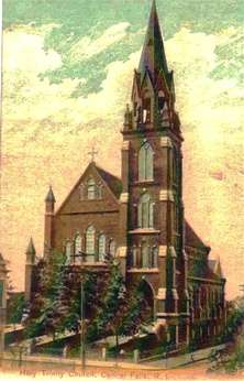
| 8 |
Holy Trinity Church Complex |
|
000000001978-01-03-0000January 3, 1978
(#78000073) |
134 Fuller Ave.
41°53′19″N 71°23′47″W / 41.888611°N 71.396389°W / 41.888611; -71.396389 (Holy Trinity Church Complex) |
Central Falls |
Church demolished; only the parish house is extant.
|
| 9 |
Jenks Park & Cogswell Tower |
|
000000001979-04-06-0000April 6, 1979
(#79000057) |
Adjoining 580 Broad St.
41°53′15″N 71°23′21″W / 41.8875°N 71.389167°W / 41.8875; -71.389167 (Jenks Park & Cogswell Tower) |
Central Falls |
|
| 10 |
St. Matthew's Church |
|
000000001979-04-06-0000April 6, 1979
(#79000008) |
Dexter and W. Hunt Sts.
41°53′21″N 71°24′07″W / 41.889167°N 71.401944°W / 41.889167; -71.401944 (St. Matthew's Church) |
Central Falls |
|
| 11 |
South Central Falls Historic District |
|
000000001991-01-31-0000January 31, 1991
(#91000025) |
Roughly bounded by the Central Falls-Pawtucket boundary and Rand, Summit, Dexter and Broad Sts.
41°53′04″N 71°23′28″W / 41.884444°N 71.391111°W / 41.884444; -71.391111 (South Central Falls Historic District) |
Central Falls |
|
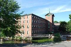
| 12 |
Valley Falls Mill |
|
000000001978-04-26-0000April 26, 1978
(#78000012) |
1359 and 1361-63 Broad St.
41°53′55″N 71°23′20″W / 41.898611°N 71.388889°W / 41.898611; -71.388889 (Valley Falls Mill) |
Central Falls |
Boundary increase December 18, 1978. |
See also
References
|
|---|
|
| Topics | | |
|---|
|
| Lists by county | |
|---|
|
| Lists by city | Bristol Coutny | |
|---|
| Kent County | |
|---|
| Newport County | |
|---|
| Providence County | |
|---|
| Washington County | |
|---|
|
|---|
|
-
 Category Category
-
 NRHP portal NRHP portal
- Massachusetts portal
|

_(extra_close)_(US48).svg.png)