| [2] |
Name on the Register[3] |
Image |
Date listed[4] |
Location |
City or town |
Description |
|---|
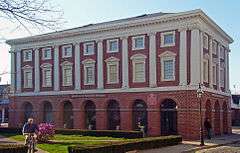
| 1 |
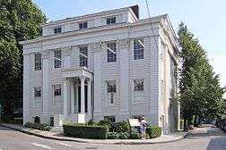
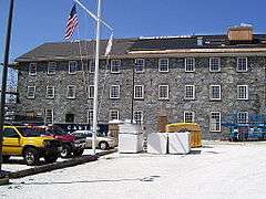
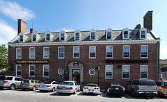
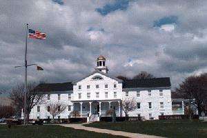
Army and Navy YMCA |
|
000000001988-12-29-0000December 29, 1988
(#88003073) |
50 Washington Sq.
41°29′26″N 71°18′51″W / 41.490556°N 71.314167°W / 41.490556; -71.314167 (Army and Navy YMCA) |
Newport |
|
| 2 |
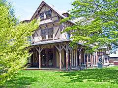
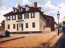
Charles H. Baldwin House |
|
000000001971-05-06-0000May 6, 1971
(#71000018) |
Bellevue Ave., opposite Perry St.
41°28′44″N 71°18′31″W / 41.478889°N 71.308611°W / 41.478889; -71.308611 (Charles H. Baldwin House) |
Newport |
|
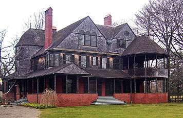
| 3 |
Isaac Bell House |
|
000000001972-01-13-0000January 13, 1972
(#72000022) |
70 Perry St.
41°28′46″N 71°18′35″W / 41.479444°N 71.309722°W / 41.479444; -71.309722 (Isaac Bell House) |
Newport |
First major Shingle-style house
|
| 4 |
Bellevue Avenue Historic District |
|
000000001972-12-08-0000December 8, 1972
(#72000023) |
Roughly bounded Atlantic Ocean, Easton Bay, Coggeshall Ave.,Spring St., and Memorial Blvd.
41°28′23″N 71°18′28″W / 41.473056°N 71.307778°W / 41.473056; -71.307778 (Bellevue Avenue Historic District) |
Newport |
Home to summer mansions and houses built by wealthy vacationers in Newport in late 19th and early 20th centuries
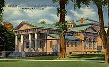
|
| 5 |
Bellevue Avenue/Casino Historic District |
|
000000001972-12-08-0000December 8, 1972
(#72000024) |
170-230 Bellvue Avenue
41°28′57″N 71°18′28″W / 41.4825°N 71.307778°W / 41.4825; -71.307778 (Bellevue Avenue/Casino Historic District) |
Newport |
|
| 6 |
The Bird's Nest |
|
000000001982-06-07-0000June 7, 1982
(#82000130) |
526 Broadway at One Mile Corner
41°30′21″N 71°18′09″W / 41.505833°N 71.3025°W / 41.505833; -71.3025 (The Bird's Nest) |
Newport |
|
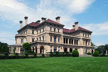
| 7 |
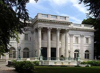
The Breakers |
|
000000001971-09-10-0000September 10, 1971
(#71000019) |
Ochre Point Ave.
41°28′11″N 71°17′56″W / 41.469722°N 71.298889°W / 41.469722; -71.298889 (The Breakers) |
Newport |
Advanced and costly mansion built by Cornelius Vanderbilt II in 1895. Considered the city's premier mansion then and now.
|
| 8 |
Brick Market |
|
000000001966-10-15-0000October 15, 1966
(#66000019) |
Thames St. & Washington Sq.
41°29′23″N 71°18′58″W / 41.489722°N 71.316111°W / 41.489722; -71.316111 (Brick Market) |
Newport |
Sophisticated late Georgian building with many classical elements. Now used as Museum of Newport History
|
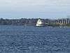
| 9 |
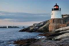
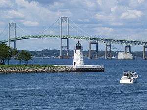
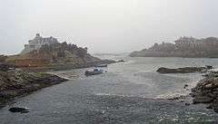
Castle Hill Lighthouse |
|
000000001988-03-30-0000March 30, 1988
(#88000277) |
Off Ocean Ave. on Castle Hill at the western end of Newport Neck
41°27′43″N 71°21′48″W / 41.461944°N 71.363333°W / 41.461944; -71.363333 (Castle Hill Lighthouse) |
Newport |
1890 lighthouse still in active use; part of the Lighthouses of Rhode Island TR
|
| 10 |
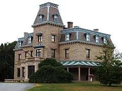
Chateau-sur-Mer |
|
000000001968-11-08-0000November 8, 1968
(#68000002) |
424 Bellevue Ave.
41°28′10″N 71°18′20″W / 41.469444°N 71.305556°W / 41.469444; -71.305556 (Chateau-sur-Mer) |
Newport |
Considered the first of the great Newport mansions.
|
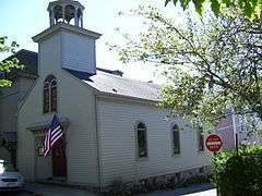
| 11 |
Clarke Street Meeting House |
|
000000001971-01-25-0000January 25, 1971
(#71000020) |
Clarke St.
41°29′22″N 71°18′51″W / 41.489444°N 71.314167°W / 41.489444; -71.314167 (Clarke Street Meeting House) |
Newport |
|
| 12 |
Commandant's Residence, Quarters Number One, Fort Adams |
|
000000001974-05-08-0000May 8, 1974
(#74000043) |
Harrison Ave., Fort Adams
41°28′17″N 71°20′33″W / 41.471389°N 71.3425°W / 41.471389; -71.3425 (Commandant's Residence, Quarters Number One, Fort Adams) |
Newport |
|
| 13 |
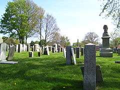
Common Burying Ground and Island Cemetery |
|
000000001974-05-01-0000May 1, 1974
(#74000044) |
Farwell and Warner Sts.
41°29′50″N 71°18′55″W / 41.497222°N 71.315278°W / 41.497222; -71.315278 (Common Burying Ground and Island Cemetery) |
Newport |
|
| 14 |
CORONET (Wooden Hull Schooner Yacht) |
|
000000002004-06-03-0000June 3, 2004
(#04000571) |
449 Thames
41°28′54″N 71°19′00″W / 41.481667°N 71.316667°W / 41.481667; -71.316667 (CORONET (Wooden Hull Schooner Yacht)) |
Newport |
|
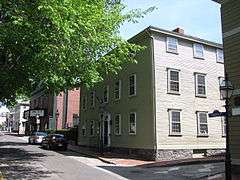
| 15 |
Dr. Charles Cotton House |
|
000000001972-01-13-0000January 13, 1972
(#72000026) |
5 Cotton's Court
41°29′18″N 71°18′53″W / 41.488333°N 71.314722°W / 41.488333; -71.314722 (Dr. Charles Cotton House) |
Newport |
|
| 16 |
William King Covell III |
|
000000001972-05-31-0000May 31, 1972
(#72000027) |
72 Washington St.
41°29′39″N 71°19′19″W / 41.494167°N 71.321944°W / 41.494167; -71.321944 (William King Covell III) |
Newport |
|
| 17 |
The Elms |
|
000000001971-09-10-0000September 10, 1971
(#71000021) |
Bellevue Ave.
41°28′38″N 71°18′38″W / 41.477222°N 71.310556°W / 41.477222; -71.310556 (The Elms) |
Newport |
One of the last and most modern of the great Newport mansions
|
| 18 |
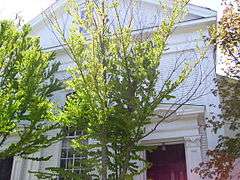
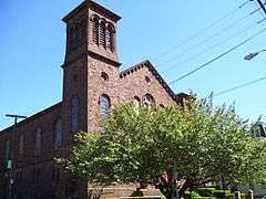
Emmanuel Church |
|
000000001996-05-16-0000May 16, 1996
(#96000574) |
42 Dearborn St.
41°28′47″N 71°18′47″W / 41.479722°N 71.313056°W / 41.479722; -71.313056 (Emmanuel Church) |
Newport |
|
| 19 |
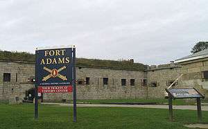
Fort Adams |
|
000000001970-07-28-0000July 28, 1970
(#70000014) |
West of Newport at Fort Adams Rd. and Harrison Ave.
41°28′30″N 71°20′28″W / 41.475°N 71.341111°W / 41.475; -71.341111 (Fort Adams) |
Newport |
|
| 20 |
Fort Hamilton Historic District |
|
000000002001-10-22-0000October 22, 2001
(#01001158) |
Rose Island
41°29′47″N 71°20′30″W / 41.496389°N 71.341667°W / 41.496389; -71.341667 (Fort Hamilton Historic District) |
Newport |
part of the Lighthouses of Rhode Island TR
|
| 21 |
Levi H. Gale House |
|
000000001971-05-06-0000May 6, 1971
(#71000022) |
89 Touro St.
41°29′21″N 71°18′45″W / 41.489167°N 71.3125°W / 41.489167; -71.3125 (Levi H. Gale House) |
Newport |
|
| 22 |
John Griswold House |
|
000000001971-11-05-0000November 5, 1971
(#71000023) |
76 Bellevue Ave
41°29′09″N 71°18′32″W / 41.485833°N 71.308889°W / 41.485833; -71.308889 (John Griswold House) |
Newport |
|
| 23 |
Hunter House |
|
000000001968-11-24-0000November 24, 1968
(#68000003) |
54 Washington St.
41°29′33″N 71°19′18″W / 41.4925°N 71.321667°W / 41.4925; -71.321667 (Hunter House) |
Newport |
Excellent example of Georgian frame house, with many interior features and original furnishings
|
| 24 |
Ida Lewis Rock Lighthouse |
|
000000001988-02-25-0000February 25, 1988
(#87001700) |
On Lime Rock in Newport Harbor off Wellington Ave.
41°28′40″N 71°19′35″W / 41.477778°N 71.326389°W / 41.477778; -71.326389 (Ida Lewis Rock Lighthouse) |
Newport |
part of the Lighthouses of Rhode Island TR
|
| 25 |
Kay Street-Catherine Street-Old Beach Road Historic District |
|
000000001973-05-22-0000May 22, 1973
(#73000052) |
Newport
41°29′23″N 71°18′19″W / 41.489722°N 71.305278°W / 41.489722; -71.305278 (Kay Street-Catherine Street-Old Beach Road Historic District) |
Newport |
|
| 26 |
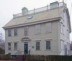
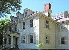
Edward King House |
|
000000001970-10-15-0000October 15, 1970
(#70000024) |
Aquidneck Park, Spring St.
41°28′56″N 71°18′41″W / 41.482222°N 71.311389°W / 41.482222; -71.311389 (Edward King House) |
Newport |
Richard Upjohn-designed Italian villa house for local merchant was the largest in the city at time of its 1847 completion.
|
| 27 |
Kingscote |
|
000000001973-05-17-0000May 17, 1973
(#73000058) |
Bellevue Ave. and Bowery St.
41°28′54″N 71°18′34″W / 41.481667°N 71.309444°W / 41.481667; -71.309444 (Kingscote) |
Newport |
1839 Gothic Revival house by Richard Upjohn was the first summer residence in Newport.
|
| 28 |
Lucas-Johnston House |
|
000000001971-05-06-0000May 6, 1971
(#71000024) |
40 Division St.
41°29′19″N 71°18′45″W / 41.488611°N 71.3125°W / 41.488611; -71.3125 (Lucas-Johnston House) |
Newport |
|
| 29 |
Luce Hall |
|
000000001972-09-22-0000September 22, 1972
(#72001439) |
US Naval War College and Torpedo School, Coasters Harbor Island
41°30′24″N 71°19′44″W / 41.506667°N 71.328889°W / 41.506667; -71.328889 (Luce Hall) |
Newport |
|
| 30 |
Malbone |
|
000000001976-10-22-0000October 22, 1976
(#76000039) |
Malbone Rd.
41°30′18″N 71°18′38″W / 41.505°N 71.310556°W / 41.505; -71.310556 (Malbone) |
Newport |
|
| 31 |
Francis Malbone House |
|
000000001975-04-28-0000April 28, 1975
(#75000055) |
392 Thames St.
41°28′58″N 71°18′54″W / 41.482778°N 71.315°W / 41.482778; -71.315 (Francis Malbone House) |
Newport |
|
| 32 |
Marble House |
|
000000001971-09-10-0000September 10, 1971
(#71000025) |
596 Bellevue Ave.
41°27′44″N 71°18′24″W / 41.462222°N 71.306667°W / 41.462222; -71.306667 (Marble House) |
Newport |
Richard Morris Hunt-designed mansion for William Kissam Vanderbilt
|
| 33 |
Capt. John Mawdsley House |
|
000000001983-07-02-0000July 2, 1983
(#83000180) |
228 Spring St.
41°29′03″N 71°18′44″W / 41.484167°N 71.312222°W / 41.484167; -71.312222 (Capt. John Mawdsley House) |
Newport |
|
| 34 |
Miantonomi Memorial Park |
|
000000001969-06-23-0000June 23, 1969
(#69000003) |
Between Hillside and Girard Aves.
41°30′32″N 71°18′37″W / 41.508889°N 71.310278°W / 41.508889; -71.310278 (Miantonomi Memorial Park) |
Newport |
|
| 35 |
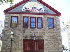
Newport Artillery Company Armory |
|
000000001972-06-30-0000June 30, 1972
(#72000029) |
23 Clarke St.
41°29′22″N 71°18′51″W / 41.489444°N 71.314167°W / 41.489444; -71.314167 (Newport Artillery Company Armory) |
Newport |
|
| 36 |
Newport Casino |
|
000000001970-12-02-0000December 2, 1970
(#70000083) |
194 Bellevue Ave.
41°28′56″N 71°18′27″W / 41.482222°N 71.3075°W / 41.482222; -71.3075 (Newport Casino) |
Newport |
Early McKim, Mead and White Shingle Style building; also first social club in U.S. to include recreational facilities. Home to International Tennis Hall of Fame.
|
| 37 |
Newport Harbor Lighthouse |
|
000000001988-03-30-0000March 30, 1988
(#88000276) |
N. end of Goat Island, Newport Harbor
41°29′36″N 71°19′39″W / 41.493333°N 71.3275°W / 41.493333; -71.3275 (Newport Harbor Lighthouse) |
Newport |
part of the Lighthouses of Rhode Island TR
|
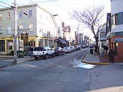
| 38 |
Newport Historic District |
|
000000001968-11-24-0000November 24, 1968
(#68000001) |
Bounded roughly by Van Zandt Ave., Newport Harbor, Thames, Pope, William Sts., Bellevue Ave., Bull, Broadway, Kingston
41°29′21″N 71°18′58″W / 41.489167°N 71.316111°W / 41.489167; -71.316111 (Newport Historic District) |
Newport |
Well-preserved collection of Georgian and colonial buildings, many showing sophistication and coordination
|
| 39 |
Newport Steam Factory |
|
000000001972-01-20-0000January 20, 1972
(#72000030) |
449 Thames St.
41°29′03″N 71°18′58″W / 41.484167°N 71.316111°W / 41.484167; -71.316111 (Newport Steam Factory) |
Newport |
|
| 40 |
Ocean Drive Historic District |
|
000000001976-05-11-0000May 11, 1976
(#76000048) |
Ocean Dr.
41°27′40″N 71°20′03″W / 41.461111°N 71.334167°W / 41.461111; -71.334167 (Ocean Drive Historic District) |
Newport |
Long road along Newport's southern shore with many summer homes and ocean views
|
| 41 |
Ochre Point-Cliffs Historic District |
|
000000001975-03-18-0000March 18, 1975
(#75000211) |
Roughly bounded by Bellevue Ave. and Coastland as far north as Memorial Boulevard and south to Sheep Point Cove
41°28′27″N 71°18′08″W / 41.474167°N 71.302222°W / 41.474167; -71.302222 (Ochre Point-Cliffs Historic District) |
Newport |
|
| 42 |
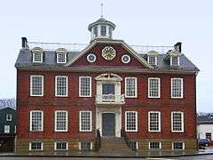
Old State House |
|
000000001966-10-15-0000October 15, 1966
(#66000014) |
Washington Sq.
41°29′27″N 71°18′48″W / 41.490833°N 71.313333°W / 41.490833; -71.313333 (Old State House) |
Newport |
Meeting place of colonial and state legislatures until 20th century; intact Georgian public building
|
| 43 |
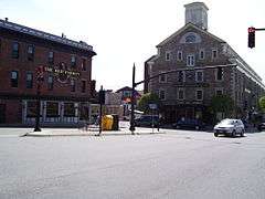
Perry Mill |
|
000000001972-01-13-0000January 13, 1972
(#72000020) |
337 Thames St.
41°29′02″N 71°18′55″W / 41.483889°N 71.315278°W / 41.483889; -71.315278 (Perry Mill) |
Newport |
|
| 44 |
President's House, Naval War College |
|
000000001989-09-18-0000September 18, 1989
(#89001219) |
Naval Education and Training Center on Coasters Harbor Island
41°30′28″N 71°19′40″W / 41.507778°N 71.327778°W / 41.507778; -71.327778 (President's House, Naval War College) |
Newport |
|
| 45 |
Redwood Library |
|
000000001966-10-15-0000October 15, 1966
(#66000015) |
50 Bellevue Ave.
41°29′12″N 71°18′34″W / 41.486667°N 71.309444°W / 41.486667; -71.309444 (Redwood Library) |
Newport |
|
| 46 |
Joseph Rogers House |
|
000000001972-02-23-0000February 23, 1972
(#72000031) |
37 Touro St.
41°29′23″N 71°18′51″W / 41.489722°N 71.314167°W / 41.489722; -71.314167 (Joseph Rogers House) |
Newport |
|
| 47 |
Rose Island Lighthouse |
|
000000001987-04-10-0000April 10, 1987
(#87000033) |
Southwestern point of Rose Island
41°29′44″N 71°20′35″W / 41.495556°N 71.343056°W / 41.495556; -71.343056 (Rose Island Lighthouse) |
Newport |
part of the Lighthouses of Rhode Island TR
|
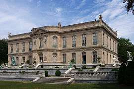
| 48 |
Rosecliff |
|
000000001973-02-06-0000February 6, 1973
(#73000059) |
Bellevue Ave.
41°27′55″N 71°18′20″W / 41.465278°N 71.305556°W / 41.465278; -71.305556 (Rosecliff) |
Newport |
|
| 49 |
Seamen's Church Institute of Newport |
|
000000001983-08-04-0000August 4, 1983
(#83000178) |
18 Market Square
41°29′14″N 71°19′01″W / 41.487222°N 71.316944°W / 41.487222; -71.316944 (Seamen's Church Institute of Newport) |
Newport |
|
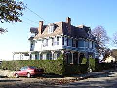
| 50 |
William Watts Sherman House |
|
000000001970-12-30-0000December 30, 1970
(#70000015) |
2 Shepard Ave.
41°28′12″N 71°18′18″W / 41.47°N 71.305°W / 41.47; -71.305 (William Watts Sherman House) |
Newport |
|
| 51 |
Shiloh Church |
|
000000001971-08-12-0000August 12, 1971
(#71000026) |
25 School St.
41°29′19″N 71°18′44″W / 41.488611°N 71.312222°W / 41.488611; -71.312222 (Shiloh Church) |
Newport |
|
| 52 |
Southern Thames Historic District |
|
000000002008-06-26-0000June 26, 2008
(#08000314) |
Thames St. from Memorial Blvd. to Morton Ave.
41°29′09″N 71°18′53″W / 41.48582°N 71.314681°W / 41.48582; -71.314681 (Southern Thames Historic District) |
Newport |
|
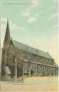
| 53 |
St. Mary's Church Complex |
|
000000002008-03-06-0000March 6, 2008
(#08000153) |
14 William St.
41°29′02″N 71°18′45″W / 41.483889°N 71.3125°W / 41.483889; -71.3125 (St. Mary's Church Complex) |
Newport |
|
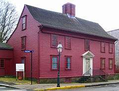
| 54 |
Ezra Stiles House |
|
000000001972-03-16-0000March 16, 1972
(#72000116) |
14 Clarke St.
41°29′23″N 71°18′50″W / 41.489722°N 71.313889°W / 41.489722; -71.313889 (Ezra Stiles House) |
Newport |
|
| 55 |
Charles Tillinghast House |
Upload image |
000000001972-01-20-0000January 20, 1972
(#72001576) |
243-245 Thames St.
41°29′19″N 71°18′54″W / 41.4886°N 71.315°W / 41.4886; -71.315 (Charles Tillinghast House) |
Newport |
|
| 56 |
John Tillinghast House |
|
000000001973-04-11-0000April 11, 1973
(#73000060) |
142 Mill St.
41°29′11″N 71°18′37″W / 41.486389°N 71.310278°W / 41.486389; -71.310278 (John Tillinghast House) |
Newport |
|
| 57 |
Touro Synagogue National Historic Site |
|
000000001966-10-15-0000October 15, 1966
(#66000927) |
85 Touro St.
41°29′23″N 71°18′45″W / 41.489722°N 71.3125°W / 41.489722; -71.3125 (Touro Synagogue National Historic Site) |
Newport |
Only surviving synagogue from colonial era
|
| 58 |
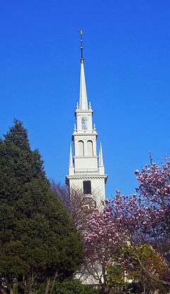
Trinity Church |
|
000000001968-11-24-0000November 24, 1968
(#68000004) |
Spring and Church Sts.
41°29′15″N 71°18′50″W / 41.4875°N 71.313889°W / 41.4875; -71.313889 (Trinity Church) |
Newport |
Oldest parish church in Rhode Island; early 18th-century design modeled on Boston's Old North Church
|
| 59 |
United Congregational Church |
|
000000001971-11-19-0000November 19, 1971
(#71000027) |
Spring and Pelham Sts.
41°29′09″N 71°18′49″W / 41.485833°N 71.313611°W / 41.485833; -71.313611 (United Congregational Church) |
Newport |
National Historic Landmark designation October 16, 2012
|
| 60 |
US Naval War College |
|
000000001966-10-15-0000October 15, 1966
(#66000876) |
Coaster's Harbor Island
41°30′24″N 71°19′44″W / 41.506667°N 71.328889°W / 41.506667; -71.328889 (US Naval War College) |
Newport |
|
| 61 |
Vernon House |
|
000000001968-11-24-0000November 24, 1968
(#68000005) |
46 Clarke St.
41°29′19″N 71°18′50″W / 41.488611°N 71.313889°W / 41.488611; -71.313889 (Vernon House) |
Newport |
Sophisticated Georgian frame house used as headquarters by Rochambeau after end of British occupation during Revolutionary War
|
| 62 |
Wanton-Lyman-Hazard House |
|
000000001966-10-15-0000October 15, 1966
(#66000016) |
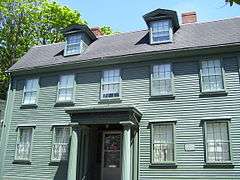
17 Broadway
41°29′27″N 71°18′48″W / 41.490833°N 71.313333°W / 41.490833; -71.313333 (Wanton-Lyman-Hazard House) |
Newport |
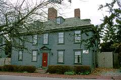
Oldest house in Newport, built in 1697.
|
| 63 |
Weatherly (sloop) |
Upload image |
000000002012-08-28-0000August 28, 2012
(#12000585) |
49 America's Cup Blvd.
41°29′15″N 71°18′59″W / 41.487397°N 71.316258°W / 41.487397; -71.316258 (Weatherly (sloop)) |
Newport |
|
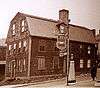
| 64 |
White Horse Tavern |
|
000000001972-02-23-0000February 23, 1972
(#72000032) |
26 Marlborough St.
41°29′30″N 71°18′51″W / 41.491667°N 71.314167°W / 41.491667; -71.314167 (White Horse Tavern) |
Newport |
One of the oldest tavern buildings in the U.S., built in 1673
|
| 65 |
Samuel Whitehorne House |
|
000000001971-05-06-0000May 6, 1971
(#71000028) |
414 Thames St.
41°28′55″N 71°18′53″W / 41.481944°N 71.314722°W / 41.481944; -71.314722 (Samuel Whitehorne House) |
Newport |
|


.jpg)

(Detroit-Publishing_Co_1894-LOC).jpg)


.jpg)
_-_from_southwest.jpg)
_(extra_close)_(US48).svg.png)