| [2] |
Name on the Register[3] |
Image |
Date listed[4] |
Location |
City or town |
Description |
|---|
| 1 |
Bouchard Archeological Site, RI-1025 |
Upload image |
000000001984-11-01-0000November 1, 1984
(#84000370) |
Address Restricted
|
South Kingstown |
Listed in Usquepaug.
|
| 2 |
Browning's Beach Historic District |
Upload image |
000000001997-09-05-0000September 5, 1997
(#97000952) |
Browning's Beach, 0.5 mi (0.80 km) west of the junction of Card Pond and Matunuck Beach Rds.
41°22′26″N 71°33′52″W / 41.373889°N 71.564444°W / 41.373889; -71.564444 (Browning's Beach Historic District) |
South Kingstown |
|
| 3 |
Jireh Bull Blockhouse |
|
000000001983-11-03-0000November 3, 1983
(#83003869) |
Address Restricted
|
South Kingstown |
|
| 4 |
Cottrell House |
Upload image |
000000001996-11-21-0000November 21, 1996
(#96001319) |
500 Waites Corner Rd.
41°29′22″N 71°33′55″W / 41.489444°N 71.565278°W / 41.489444; -71.565278 (Cottrell House) |
South Kingstown |
|
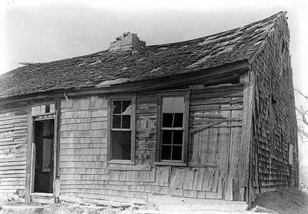
| 5 |
Dewey Cottage |
Upload image |
000000001992-05-07-0000May 7, 1992
(#92000467) |
668 Matunuck Beach Rd.
41°22′42″N 71°32′56″W / 41.378333°N 71.548889°W / 41.378333; -71.548889 (Dewey Cottage) |
South Kingstown |
|
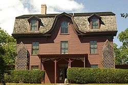
| 6 |
Henry Eldred Farm |
Upload image |
000000001991-11-18-0000November 18, 1991
(#91001646) |
368 Old North Rd.
41°29′55″N 71°31′14″W / 41.498611°N 71.520556°W / 41.498611; -71.520556 (Henry Eldred Farm) |
South Kingstown |
|
| 7 |
George Fayerweather Blacksmith Shop |
|
000000001984-11-29-0000November 29, 1984
(#84000470) |
Intersection RI 108 and 138
41°28′49″N 71°31′13″W / 41.48038°N 71.52018°W / 41.48038; -71.52018 (George Fayerweather Blacksmith Shop) |
South Kingstown |
|
| 8 |
Fernwood Archeological Site, RI-702 |
Upload image |
000000001985-09-12-0000September 12, 1985
(#85002364) |
Address Restricted
|
South Kingstown |
|
| 9 |
R. R. Gardner House |
Upload image |
000000001996-11-21-0000November 21, 1996
(#96001320) |
700 Curtis Corner Rd.
41°27′10″N 71°31′54″W / 41.452778°N 71.531667°W / 41.452778; -71.531667 (R. R. Gardner House) |
South Kingstown |
|
| 10 |
Hale House |
|
000000002007-06-05-0000June 5, 2007
(#07000527) |
2625A Commodore Oliver Hazard Perry Highway
41°23′52″N 71°33′03″W / 41.397778°N 71.550833°W / 41.397778; -71.550833 (Hale House) |
South Kingstown |
|
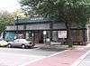
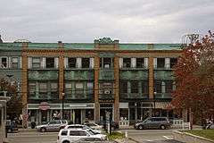
| 11 |
Kenyon's Department Store |
|
000000001992-11-05-0000November 5, 1992
(#92001540) |
344 Main St.
41°26′17″N 71°29′59″W / 41.438056°N 71.499722°W / 41.438056; -71.499722 (Kenyon's Department Store) |
South Kingstown |
|
| 12 |
Kingston Hill Farm |
Upload image |
000000001993-05-07-0000May 7, 1993
(#93000343) |
549 Old North Rd.
41°29′41″N 71°30′51″W / 41.494722°N 71.514167°W / 41.494722; -71.514167 (Kingston Hill Farm) |
South Kingstown |
|
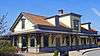
| 13 |
Kingston Railroad Station |
|
000000001978-04-26-0000April 26, 1978
(#78000018) |
Kingston Rd.
41°29′03″N 71°33′39″W / 41.484167°N 71.560833°W / 41.484167; -71.560833 (Kingston Railroad Station) |
South Kingstown |
Restored 1875 original station built by Providence and Stonington Railroad; still used today.
|
| 14 |
Kingston Village Historic District |
|
000000001974-05-01-0000May 1, 1974
(#74000011) |
South Kingstown
41°28′48″N 71°31′29″W / 41.48°N 71.524722°W / 41.48; -71.524722 (Kingston Village Historic District) |
South Kingstown |
|
| 15 |
Lambda Chi Site, RI-704 |
Upload image |
000000001984-11-01-0000November 1, 1984
(#84000372) |
Address Restricted
|
South Kingstown |
|
| 16 |
Henry Marchant Farm |
|
000000001979-08-16-0000August 16, 1979
(#79000009) |
S. County Trail
41°28′52″N 71°35′56″W / 41.481111°N 71.598889°W / 41.481111; -71.598889 (Henry Marchant Farm) |
South Kingstown |
|
| 17 |
William Davis Miller House |
|
000000001985-03-21-0000March 21, 1985
(#85000627) |
130 Main St.
41°26′08″N 71°30′27″W / 41.435556°N 71.5075°W / 41.435556; -71.5075 (William Davis Miller House) |
South Kingstown |
|
| 18 |
Ministerial Rd. Site, RI-781 |
Upload image |
000000001984-11-15-0000November 15, 1984
(#84000565) |
Address Restricted
|
South Kingstown |
|
| 19 |
Silas Mumford Site (Tappan Site RI-705) |
Upload image |
000000001984-11-01-0000November 1, 1984
(#84000382) |
Address Restricted
|
South Kingstown |
|
| 20 |
Peace Dale Historic District |
|
000000001987-10-30-0000October 30, 1987
(#87000493) |
Roughly bounded by Kensey Rd., Oakwoods Dr., Kingstown Rd., School, Church and Railroad Sts.
41°27′04″N 71°29′42″W / 41.451111°N 71.495°W / 41.451111; -71.495 (Peace Dale Historic District) |
South Kingstown |
|
| 21 |
Commodore Oliver Perry Farm |
Upload image |
000000001982-08-26-0000August 26, 1982
(#82000020) |
Commodore Perry Highway (US Route 1)
41°25′08″N 71°31′51″W / 41.4190°N 71.5307°W / 41.4190; -71.5307 (Commodore Oliver Perry Farm) |
South Kingstown |
|
| 22 |
Perry-Carpenter Grist Mill |
Upload image |
000000001990-02-22-0000February 22, 1990
(#90000106) |
364 Moonstone Beach Rd.
41°23′35″N 71°34′34″W / 41.392956°N 71.576072°W / 41.392956; -71.576072 (Perry-Carpenter Grist Mill) |
South Kingstown |
|
| 23 |
Potter Pond Archeological District |
Upload image |
000000001987-12-08-0000December 8, 1987
(#87002102) |
Address Restricted
|
South Kingstown |
|
| 24 |
Red House |
Upload image |
000000001996-11-21-0000November 21, 1996
(#96001323) |
2403 Post Rd.
41°24′02″N 71°34′15″W / 41.400556°N 71.570833°W / 41.400556; -71.570833 (Red House) |
South Kingstown |
|
| 25 |
Gen. Isaac Peace Rodman House |
Upload image |
000000001990-04-23-0000April 23, 1990
(#90000596) |
1789 Kingstown Rd.
41°27′48″N 71°30′33″W / 41.463333°N 71.509167°W / 41.463333; -71.509167 (Gen. Isaac Peace Rodman House) |
South Kingstown |
|
| 26 |
Shadow Farm |
Upload image |
000000001986-02-07-0000February 7, 1986
(#86000785) |
Kingstown Rd.
41°26′15″N 71°29′28″W / 41.4375°N 71.491111°W / 41.4375; -71.491111 (Shadow Farm) |
South Kingstown |
|
| 27 |
Theatre-By-the-Sea |
|
000000001980-07-10-0000July 10, 1980
(#80004597) |
Card Ponds Rd.
41°22′37″N 71°33′46″W / 41.376944°N 71.562778°W / 41.376944; -71.562778 (Theatre-By-the-Sea) |
South Kingstown |
|
| 28 |
Tootell House |
Upload image |
000000002000-05-26-0000May 26, 2000
(#00000552) |
1747 Mooresfield Rd.
41°28′51″N 71°31′02″W / 41.480833°N 71.517222°W / 41.480833; -71.517222 (Tootell House) |
South Kingstown |
|
| 29 |
Usquepaug Road Historic District |
|
000000001987-10-30-0000October 30, 1987
(#87001298) |
Usquepaug Rd.
41°30′14″N 71°36′01″W / 41.503889°N 71.600278°W / 41.503889; -71.600278 (Usquepaug Road Historic District) |
South Kingstown |
|
| 30 |
Wakefield Historic District |
|
000000001996-05-30-0000May 30, 1996
(#96000572) |
Roughly, Main St. from Belmont Ave. to Columbia St.
41°26′15″N 71°30′04″W / 41.4375°N 71.501111°W / 41.4375; -71.501111 (Wakefield Historic District) |
South Kingstown |
|
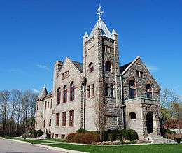
| 31 |
Washington County Court House |
|
000000001992-11-05-0000November 5, 1992
(#92001542) |
3481 Kingstown Rd.
41°29′02″N 71°33′21″W / 41.483889°N 71.555833°W / 41.483889; -71.555833 (Washington County Court House) |
South Kingstown |
former county courthouse, now an arts center
|
| 32 |
Willow Dell |
Upload image |
000000001996-11-21-0000November 21, 1996
(#96001321) |
2700 Commodore Oliver Hazard Perry Highway
41°23′47″N 71°33′04″W / 41.396389°N 71.551111°W / 41.396389; -71.551111 (Willow Dell) |
South Kingstown |
|


_(extra_close)_(US48).svg.png)