National Register of Historic Places listings in East Greenwich, Rhode Island
List of Registered Historic Places in East Greenwich, Rhode Island, which has been transferred from and is an integral part of National Register of Historic Places listings in Kent County, Rhode Island
- This National Park Service list is complete through NPS recent listings posted December 2, 2016.[1]
| [2] |
Name on the Register[3] |
Image |
Date listed[4] |
Location |
City or town |
Description |
|---|
| 1 |
Armory of the Kentish Guards |
|
000000001970-04-28-0000April 28, 1970
(#70000012) |
Armory and Peirce Sts.
41°39′44″N 71°27′05″W / 41.662222°N 71.451389°W / 41.662222; -71.451389 (Armory of the Kentish Guards) |
East Greenwich |
|
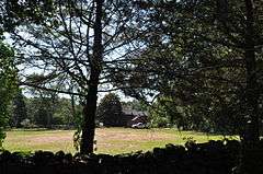
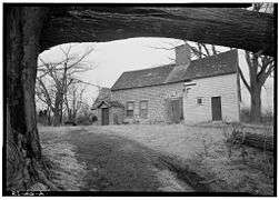
| 2 |
Richard Briggs Farm |
|
000000002003-06-06-0000June 6, 2003
(#03000517) |
830 South Rd.
41°36′25″N 71°30′38″W / 41.606944°N 71.510556°W / 41.606944; -71.510556 (Richard Briggs Farm) |
East Greenwich |
|
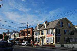
| 3 |
East Greenwich Historic District |
|
000000001974-06-13-0000June 13, 1974
(#74000036) |
Roughly bounded by Kenyon Ave., Division, Peirce, and London Sts., Greenwich Cove and Dark Entry Brook
41°39′43″N 71°27′17″W / 41.661944°N 71.454722°W / 41.661944; -71.454722 (East Greenwich Historic District) |
East Greenwich and Warwick |
|
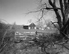
| 4 |
Fry's Hamlet Historic District |
|
000000001985-12-20-0000December 20, 1985
(#85003161) |
2068, 2153, 2196, and 2233 S. County Trail
41°38′21″N 71°29′58″W / 41.639167°N 71.499444°W / 41.639167; -71.499444 (Fry's Hamlet Historic District) |
East Greenwich |
|
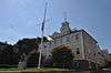
| 5 |
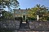
Kent County Courthouse |
|
000000001970-04-28-0000April 28, 1970
(#70000013) |
127 Main St.
41°39′39″N 71°27′02″W / 41.660833°N 71.450556°W / 41.660833; -71.450556 (Kent County Courthouse) |
East Greenwich |
Now East Greenwich Town Hall
|
| 6 |
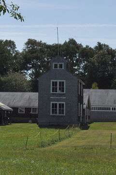
Massie Wireless Station |
|
000000002001-10-22-0000October 22, 2001
(#01001157) |
1300 Frenchtown Rd. (New England Wireless and Steam Museum)
41°37′33″N 71°30′45″W / 41.625833°N 71.5125°W / 41.625833; -71.5125 (Massie Wireless Station) |
East Greenwich |
|
| 7 |
Spencer–Shippee–Lillbridge House |
|
000000002011-04-20-0000April 20, 2011
(#11000207) |
12 Middle Rd.
41°39′16″N 71°27′51″W / 41.654444°N 71.464167°W / 41.654444; -71.464167 (Spencer–Shippee–Lillbridge House) |
East Greenwich |
|
| 8 |
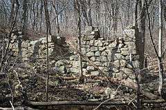
Tillinghast Mill Site |
|
000000001988-03-10-0000March 10, 1988
(#88000164) |
Frenchtown Park
41°37′41″N 71°30′23″W / 41.62805°N 71.506326°W / 41.62805; -71.506326 (Tillinghast Mill Site) |
East Greenwich |
|
| 9 |
Tillinghast Road Historic District |
|
000000001988-03-09-0000March 9, 1988
(#88000167) |
Tillinghast Rd.
41°37′03″N 71°30′39″W / 41.6175°N 71.510833°W / 41.6175; -71.510833 (Tillinghast Road Historic District) |
East Greenwich |
|
| 10 |
Gen. James Mitchell Varnum House |
|
000000001971-08-12-0000August 12, 1971
(#71000016) |
57 Peirce St.
41°39′49″N 71°27′06″W / 41.663611°N 71.451667°W / 41.663611; -71.451667 (Gen. James Mitchell Varnum House) |
East Greenwich |
|
| 11 |
Clement Weaver-Daniel Howland House |
|
000000001995-11-07-0000November 7, 1995
(#95001266) |
125 Howland Rd.
41°39′32″N 71°28′40″W / 41.658889°N 71.477778°W / 41.658889; -71.477778 (Clement Weaver-Daniel Howland House) |
East Greenwich |
|
| 12 |
Col. Micah Whitmarsh House |
|
000000001971-02-18-0000February 18, 1971
(#71000017) |
294 Main St.
41°39′34″N 71°27′01″W / 41.659444°N 71.450278°W / 41.659444; -71.450278 (Col. Micah Whitmarsh House) |
East Greenwich |
|
| 13 |
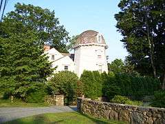
Windmill Cottage |
|
000000001973-05-22-0000May 22, 1973
(#73000051) |
144 Division St.
41°39′49″N 71°27′23″W / 41.663611°N 71.456389°W / 41.663611; -71.456389 (Windmill Cottage) |
East Greenwich |
|
See also
References
|
|---|
|
| Topics | | |
|---|
|
| Lists by county | |
|---|
|
| Lists by city | Bristol Coutny | |
|---|
| Kent County | |
|---|
| Newport County | |
|---|
| Providence County | |
|---|
| Washington County | |
|---|
|
|---|
|
-
 Category Category
-
 NRHP portal NRHP portal
- Massachusetts portal
|


_(extra_close)_(US48).svg.png)