National Register of Historic Places listings in Portsmouth, Rhode Island
This is a list of Registered Historic Places in Portsmouth, Rhode Island, which has been transferred from and is an integral part of National Register of Historic Places listings in Newport County, Rhode Island.
- This National Park Service list is complete through NPS recent listings posted December 2, 2016.[1]
| [2] |
Name on the Register[3] |
Image |
Date listed[4] |
Location |
City or town |
Description |
|---|
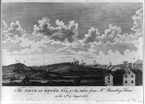
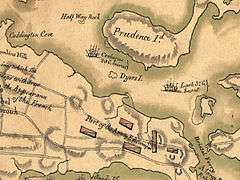
| 1 |
Battle of Rhode Island Site |
|
000000001974-05-30-0000May 30, 1974
(#74002054) |
Lehigh Hill and both sides of RI 24 between Medley and Dexter Sts.
41°36′12″N 71°15′31″W / 41.603333°N 71.258611°W / 41.603333; -71.258611 (Battle of Rhode Island Site) |
Portsmouth |
Successful defense against British in 1778. Only Revolutionary War battle in which a segregated African-American unit fought (support logistics, 2 killed).
|
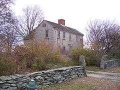
| 2 |
Borden Farm |
|
000000002007-06-05-0000June 5, 2007
(#07000528) |
2951 and 2967 E. Main Rd.
41°36′32″N 71°14′45″W / 41.608889°N 71.245833°W / 41.608889; -71.245833 (Borden Farm) |
Portsmouth |
|
| 3 |
Farnham Farm |
Upload image |
000000002006-02-02-0000February 2, 2006
(#05001617) |
113 Mount Pleasant Ave.
41°35′52″N 71°19′22″W / 41.5979°N 71.3229°W / 41.5979; -71.3229 (Farnham Farm) |
Portsmouth |
|
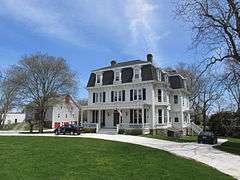
| 4 |
Greenvale Farm |
|
000000001980-01-04-0000January 4, 1980
(#80000082) |
582 Wapping Rd.
41°32′05″N 71°14′18″W / 41.534722°N 71.238333°W / 41.534722; -71.238333 (Greenvale Farm) |
Portsmouth |
19th century estate house on the water below Greenvale Vineyard.
|
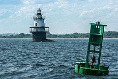
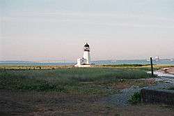
| 5 |
Hog Island Shoal Lighthouse |
|
000000001988-03-30-0000March 30, 1988
(#88000282) |
S of Hog Island, E passage, Narrangansett Bay
41°37′56″N 71°16′25″W / 41.632222°N 71.273611°W / 41.632222; -71.273611 (Hog Island Shoal Lighthouse) |
Portsmouth |
|
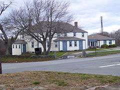
| 6 |
Lawton-Almy-Hall Farm |
|
000000001978-10-11-0000October 11, 1978
(#78000068) |
559 Union St.
41°33′35″N 71°16′31″W / 41.559722°N 71.275278°W / 41.559722; -71.275278 (Lawton-Almy-Hall Farm) |
Portsmouth |
|
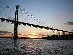
| 7 |
Mount Hope Bridge |
|
000000001976-01-31-0000January 31, 1976
(#76000038) |
RI 114 over Narragansett Bay
41°38′25″N 71°15′32″W / 41.640278°N 71.258889°W / 41.640278; -71.258889 (Mount Hope Bridge) |
Portsmouth |
Longest bridge in New England for over 40 years
|
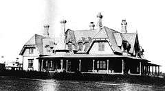
| 8 |
Oak Glen |
|
000000001978-03-29-0000March 29, 1978
(#78003444) |
745 Union St.
41°33′33″N 71°16′53″W / 41.559167°N 71.281389°W / 41.559167; -71.281389 (Oak Glen) |
Portsmouth |
|
| 9 |
Pine Hill Archeological Site, RI-655 |
Upload image |
000000001983-11-03-0000November 3, 1983
(#83003803) |
Address Restricted
|
Portsmouth |
|
| 10 |
Portsmouth Friends Meetinghouse Parsonage and Cemetery |
|
000000001973-03-07-0000March 7, 1973
(#73000053) |
11 Middle Rd. and 2232 E. Main Rd.
41°35′27″N 71°15′14″W / 41.590722°N 71.253822°W / 41.590722; -71.253822 (Portsmouth Friends Meetinghouse Parsonage and Cemetery) |
Portsmouth |
|
| 11 |
Prudence Island Lighthouse |
|
000000001988-03-30-0000March 30, 1988
(#88000270) |
Eastern end of Sandy Pt. on Prudence Island
41°36′20″N 71°18′11″W / 41.605556°N 71.303056°W / 41.605556; -71.303056 (Prudence Island Lighthouse) |
Portsmouth |
part of the Lighthouses of Rhode Island TR
|
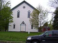
| 12 |
Union Church |
|
000000001974-06-13-0000June 13, 1974
(#74000045) |
Union St. and E. Main Rd.
41°33′30″N 71°15′22″W / 41.558333°N 71.256111°W / 41.558333; -71.256111 (Union Church) |
Portsmouth |
|
| 13 |
Wreck Sites of H.M.S. Cerberus and H.M.S. Lark |
|
000000001973-04-26-0000April 26, 1973
(#73000061) |
Waters of Narragansett Bay adjacent to Aquidneck Island
41°35′04″N 71°18′19″W / 41.584444°N 71.305278°W / 41.584444; -71.305278 (Wreck Sites of H.M.S. Cerberus and H.M.S. Lark) |
South Portsmouth |
|
See also
References
|
|---|
|
| Topics | | |
|---|
|
| Lists by county | |
|---|
|
| Lists by city | Bristol Coutny | |
|---|
| Kent County | |
|---|
| Newport County | |
|---|
| Providence County | |
|---|
| Washington County | |
|---|
|
|---|
|
-
 Category Category
-
 NRHP portal NRHP portal
- Massachusetts portal
|
_(extra_close)_(US48).svg.png)