| [2] |
Name on the Register |
Image |
Date listed[3] |
Location |
City or town |
Description |
|---|
| 1 |
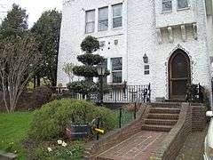
Barkin House |
Upload image |
000000002015-05-18-0000May 18, 2015
(#15000234) |
84 E. Olive St.
40°35′12″N 73°39′49″W / 40.5867753°N 73.6636377°W / 40.5867753; -73.6636377 (Barkin House) |
Long Beach |
Late 1940s International Style beach house
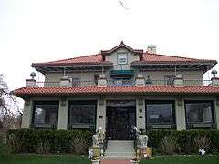
|
| 2 |
Bellerose Village Municipal Complex |
|
000000002006-09-28-0000September 28, 2006
(#06000889) |
50 Superior Road and Magee Plaza
40°43′21″N 73°43′01″W / 40.7225°N 73.716944°W / 40.7225; -73.716944 (Bellerose Village Municipal Complex) |
Bellerose |
|
| 3 |
Cobble Villa |
Upload image |
000000002015-01-27-0000January 27, 2015
(#14001214) |
657 Laurelton Blvd
40°35′33″N 73°40′31″W / 40.592585°N 73.6752757°W / 40.592585; -73.6752757 (Cobble Villa) |
Long Beach |
1912 Mediterranean Revival villa is one of the few remaining properties from seaside resort community developed by William H. Reynolds
|
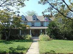
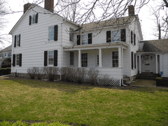
| 4 |
Denton Homestead |
|
000000002014-11-12-0000November 12, 2014
(#14000913) |
60 Denton Ave.
40°38′33″N 73°39′54″W / 40.642454°N 73.6649957°W / 40.642454; -73.6649957 (Denton Homestead) |
East Rockaway |
Originally built as a late 18th century tavern, it later become to one of the early founders and planners of East Rockaway.
|
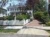
| 5 |
Pauline Felix House |
|
000000002005-02-24-0000February 24, 2005
(#05000090) |
151 West Penn Street
40°35′08″N 73°40′20″W / 40.585556°N 73.672222°W / 40.585556; -73.672222 (Pauline Felix House) |
Long Beach |
|
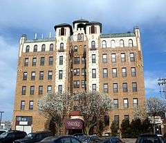
| 6 |
Granada Towers |
|
000000001984-05-31-0000May 31, 1984
(#84002750) |
310 Riverside Boulevard
40°35′17″N 73°39′40″W / 40.588056°N 73.661111°W / 40.588056; -73.661111 (Granada Towers) |
Long Beach |
|
| 7 |
Haviland-Davison Grist Mill |
|
000000001998-04-21-0000April 21, 1998
(#98000352) |
Jct. of Woods and Denton Avenues
40°38′47″N 73°39′49″W / 40.646389°N 73.663611°W / 40.646389; -73.663611 (Haviland-Davison Grist Mill) |
East Rockaway |
|
| 8 |
House at 226 West Penn Street |
|
000000002008-09-24-0000September 24, 2008
(#08000932) |
226 West Penn Street
40°35′07″N 73°40′15″W / 40.585258°N 73.670942°W / 40.585258; -73.670942 (House at 226 West Penn Street) |
Long Beach |
Headquarters for the Long Beach Historical Society.
|
| 9 |
House at 251 Rocklyn Avenue |
|
000000002008-11-07-0000November 7, 2008
(#07001454) |
251 Rocklyn Avenue
40°39′07″N 73°39′54″W / 40.651817°N 73.665092°W / 40.651817; -73.665092 (House at 251 Rocklyn Avenue) |
Lynbrook |
|
| 10 |
House at 474 Ocean Avenue |
|
000000002008-11-07-0000November 7, 2008
(#07001455) |
474 Ocean Avenue
40°39′15″N 73°39′29″W / 40.654139°N 73.658194°W / 40.654139; -73.658194 (House at 474 Ocean Avenue) |
Lynbrook |
|
| 11 |
House at 73 Grove Street |
|
000000002008-01-23-0000January 23, 2008
(#07001453) |
73 Grove Street
40°39′54″N 73°40′02″W / 40.665°N 73.667222°W / 40.665; -73.667222 (House at 73 Grove Street) |
Lynbrook |
|
| 12 |
Samuel and Elbert Jackson House |
|
000000002006-07-14-0000July 14, 2006
(#06000563) |
1542 Wantagh Avenue
40°41′04″N 73°30′39″W / 40.684444°N 73.510833°W / 40.684444; -73.510833 (Samuel and Elbert Jackson House) |
Wantagh |
|
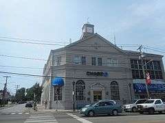
| 13 |
Franklin Square National Bank |
|
000000002015-11-10-0000November 10, 2015
(#15000776) |
952 Hempstead Turnpike
40°42′27″N 73°40′39″W / 40.7075078°N 73.6774418°W / 40.7075078; -73.6774418 (Franklin Square National Bank) |
Franklin Square |
1926 bank building expanded at midcentury under leadership of Arthur T. Roth, who made many consumer-friendly innovations such as the first parking lot owned by a bank, the first outdoor teller's window and the first bank credit card
|
| 14 |
Jerusalem District No. 5 Schoolhouse |
Upload image |
000000001996-03-01-0000March 1, 1996
(#96000204) |
Old Jerusalem Road
40°42′08″N 73°30′27″W / 40.702222°N 73.5075°W / 40.702222; -73.5075 (Jerusalem District No. 5 Schoolhouse) |
Levittown |
One room schoolhouse
|
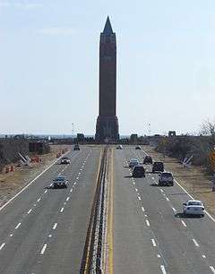
| 15 |
Jones Beach State Park, Causeway and Parkway System |
|
000000002005-04-28-0000April 28, 2005
(#05000358) |
Ocean, Wantagh, Meadowbrook and Loop State Parkways
40°36′51″N 73°32′10″W / 40.614167°N 73.536111°W / 40.614167; -73.536111 (Jones Beach State Park, Causeway and Parkway System) |
Wantagh |
Early Robert Moses project in late 1920s opened Long Island beaches to public and led to many more Long Island state parks and parkways
|
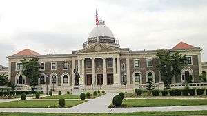
| 16 |
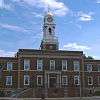
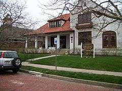
Old Nassau County Courthouse |
|
000000001978-02-17-0000February 17, 1978
(#78001863) |
1550 Franklin Avenue
40°44′16″N 73°38′24″W / 40.737778°N 73.64°W / 40.737778; -73.64 (Old Nassau County Courthouse) |
Garden City |
|
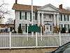
| 17 |
Pagan-Fletcher House |
|
000000001983-09-08-0000September 8, 1983
(#83001715) |
143 Hendrickson Avenue
40°40′12″N 73°41′52″W / 40.67°N 73.697778°W / 40.67; -73.697778 (Pagan-Fletcher House) |
Valley Stream |
|
| 18 |
Rectory of St. George's Episcopal Church |
|
000000001988-05-03-0000May 3, 1988
(#88000510) |
217 Peninsula Boulevard
40°42′18″N 73°37′18″W / 40.705°N 73.621667°W / 40.705; -73.621667 (Rectory of St. George's Episcopal Church) |
Hempstead |
|
| 19 |
Rock Hall |
|
000000001976-11-21-0000November 21, 1976
(#76001230) |
199 Broadway
40°36′32″N 73°44′05″W / 40.608889°N 73.734722°W / 40.608889; -73.734722 (Rock Hall) |
Lawrence |
|
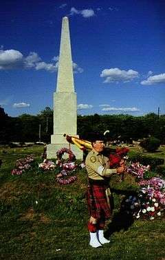
| 20 |
Rockville Cemetery and Bristol and Mexico Monument |
|
000000002015-11-16-0000November 16, 2015
(#15000801) |
45 Merrick Road
40°39′31″N 73°39′41″W / 40.6587273°N 73.6613503°W / 40.6587273; -73.6613503 (Rockville Cemetery and Bristol and Mexico Monument) |
Lynbrook |
Started as a small local burial ground in 1799, it subsequently came to be the final resting place of many early Near Rockaway settlers. Monuments to two nearby 1840s shipwrecks that resulted in changes to New York Harbor approach practices mark mass grave of 139 passengers, mostly Irish immigrants fleeing famine.
|
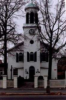
| 21 |
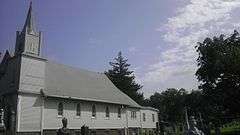
St. George's Church |
|
000000001973-03-07-0000March 7, 1973
(#73001211) |
319 Front Street
40°42′24″N 73°37′23″W / 40.706667°N 73.623056°W / 40.706667; -73.623056 (St. George's Church) |
Hempstead |
|
| 22 |
St. Paul's German Presbyterian Church and Cemetery |
|
000000002008-09-26-0000September 26, 2008
(#08000931) |
525 Elmont Rd.
40°41′48″N 73°42′54″W / 40.6968°N 73.7151°W / 40.6968; -73.7151 (St. Paul's German Presbyterian Church and Cemetery) |
Elmont |
|
| 23 |
A. T. Stewart Era Buildings |
|
000000001978-11-14-0000November 14, 1978
(#78001864) |
4th, 5th, and 6th Streets, Cathedral and Cherry Valley Avenues
40°43′21″N 73°38′27″W / 40.7225°N 73.640833°W / 40.7225; -73.640833 (A. T. Stewart Era Buildings) |
Garden City |
|
| 24 |
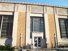
US Post Office-Freeport |
|
000000001989-05-11-0000May 11, 1989
(#88002517) |
132 Merrick Road
40°39′13″N 73°35′10″W / 40.653611°N 73.586111°W / 40.653611; -73.586111 (US Post Office-Freeport) |
Freeport |
|
| 25 |
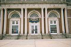
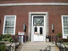
US Post Office-Garden City |
|
000000001989-05-11-0000May 11, 1989
(#88002521) |
600 Franklin Street
40°43′29″N 73°38′04″W / 40.724722°N 73.634444°W / 40.724722; -73.634444 (US Post Office-Garden City) |
Garden City |
|
| 26 |
US Post Office-Hempstead |
|
000000001988-11-17-0000November 17, 1988
(#88002499) |
200 Fulton Avenue
40°42′26″N 73°37′43″W / 40.707222°N 73.628611°W / 40.707222; -73.628611 (US Post Office-Hempstead) |
Hempstead |
|
| 27 |
US Post Office-Long Beach |
|
000000001989-05-11-0000May 11, 1989
(#88002347) |
101 East Park Avenue
40°35′19″N 73°39′39″W / 40.588611°N 73.660833°W / 40.588611; -73.660833 (US Post Office-Long Beach) |
Long Beach |
|
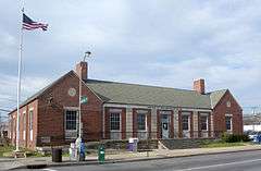
| 28 |
US Post Office-Rockville Centre |
|
000000001989-05-11-0000May 11, 1989
(#88002425) |
250 Merrick Road
40°39′22″N 73°38′48″W / 40.656111°N 73.646667°W / 40.656111; -73.646667 (US Post Office-Rockville Centre) |
Rockville Centre |
|
| 29 |
Samuel Vaisberg House |
|
000000002005-10-05-0000October 5, 2005
(#05001137) |
257 West Olive Street
40°35′13″N 73°40′22″W / 40.586944°N 73.672778°W / 40.586944; -73.672778 (Samuel Vaisberg House) |
Long Beach |
|
| 30 |
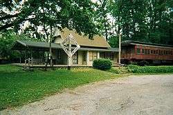
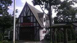
Wantagh Railroad Complex |
|
000000001983-06-30-0000June 30, 1983
(#83001716) |
1700 Wantagh Avenue
40°40′49″N 73°30′38″W / 40.680278°N 73.510556°W / 40.680278; -73.510556 (Wantagh Railroad Complex) |
Wantagh |
|
.jpg)
.jpg)

.JPG)