| [2] |
Name on the Register |
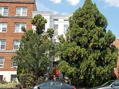
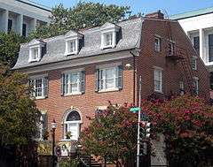
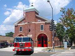
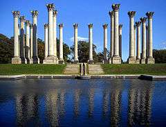
Image |
Date listed[3] |
Location |
City or town |
Description |
|---|
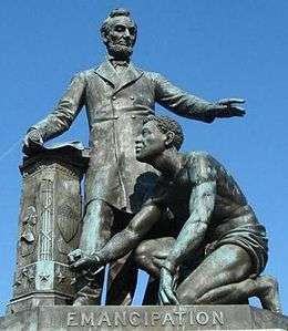
| 1 |
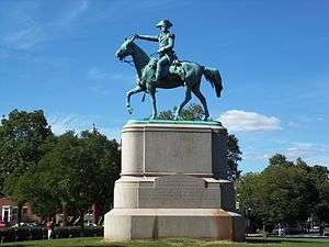
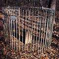
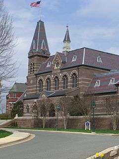
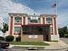
American Revolution Statuary |
|
000000001978-07-14-0000July 14, 1978
(#78000256) |
Public buildings and various parks within DC
38°53′37″N 76°59′59″W / 38.893611°N 76.999722°W / 38.893611; -76.999722 (American Revolution Statuary) |
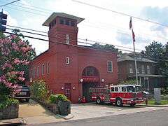
Stanton Park |
14 statues including 11 in central DC, and the General Nathanael Greene statue in Stanton Park
|
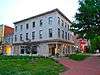
| 2 |
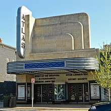
Atlas Theater and Shops |
|
000000002010-11-10-0000November 10, 2010
(#10000909) |
1313-33 H Street, NE
38°53′59″N 76°59′15″W / 38.899722°N 76.9875°W / 38.899722; -76.9875 (Atlas Theater and Shops) |
Near Northeast |
|
| 3 |
Mountjoy Bayly House |
|
000000001973-07-20-0000July 20, 1973
(#73002072) |
122 Maryland Ave., NE
38°53′29″N 77°00′18″W / 38.891389°N 77.005°W / 38.891389; -77.005 (Mountjoy Bayly House) |
Capitol Hill |
|
| 4 |
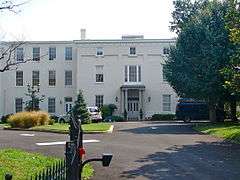
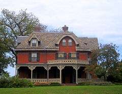
Brooks Mansion |
|
000000001975-07-17-0000July 17, 1975
(#75002045) |
901 Newton St., NE.
38°55′58″N 76°59′37″W / 38.932778°N 76.993611°W / 38.932778; -76.993611 (Brooks Mansion) |
NE |
|
| 5 |
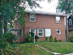
Ralph Bunche House |
|
000000001993-09-30-0000September 30, 1993
(#93001013) |
1510 Jackson St., NE.
38°55′47″N 76°59′02″W / 38.929722°N 76.983889°W / 38.929722; -76.983889 (Ralph Bunche House) |
NE |
|
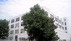
| 6 |
Bunker Hill Elementary School |
|
000000002014-05-05-0000May 5, 2014
(#14000186) |
1401 Michigan Ave., NE
38°56′31″N 76°59′06″W / 38.942004°N 76.984969°W / 38.942004; -76.984969 (Bunker Hill Elementary School) |
Brookland |
|
| 7 |
Capitol Hill Historic District |
|
000000001976-08-27-0000August 27, 1976
(#76002127) |
Roughly bounded by Virginia Ave., SE., S. Capitol St., F St. NE., and 14th Sts. SE & NE.
38°53′13″N 76°59′51″W / 38.886944°N 76.9975°W / 38.886944; -76.9975 (Capitol Hill Historic District) |
NE, SE and NW |
Boundary increase (listed July 3, 2003): Roughly bounded by 7th St. NE, I-295, M St. SE and 11th St. SE
|
| 8 |
Chesapeake and Potomac Telephone Company Warehouse and Repair Facility |
|
000000002007-05-14-0000May 14, 2007
(#06001159) |
1111 N. Capitol St. NE
38°54′15″N 77°00′32″W / 38.9043°N 77.009°W / 38.9043; -77.009 (Chesapeake and Potomac Telephone Company Warehouse and Repair Facility) |
NE |
|
| 9 |
Children's Country Home |
|
000000002003-12-09-0000December 9, 2003
(#03001254) |
1731 Bunker Hill Rd. NE
38°56′29″N 76°58′39″W / 38.941389°N 76.9775°W / 38.941389; -76.9775 (Children's Country Home) |
Woodridge |
|
| 10 |
Civil War Monuments in Washington, DC |
|
000000001978-09-20-0000September 20, 1978
(#78000257) |
Various parks within the original boundaries of city
38°53′23″N 76°59′25″W / 38.889722°N 76.990278°W / 38.889722; -76.990278 (Civil War Monuments in Washington, DC) |
Various |
18 statues about people and topics related to the Civil War, including 1 in Lincoln Park (NE & SE quadrants), 6 in the upper NW quadrant, and 11 in central Washington.
|
| 11 |
Alexander Crummell School |
|
000000002003-07-25-0000July 25, 2003
(#03000671) |
Kendall and Gallaudet Sts, NE
38°54′48″N 76°59′07″W / 38.913333°N 76.985278°W / 38.913333; -76.985278 (Alexander Crummell School) |
NE |
|
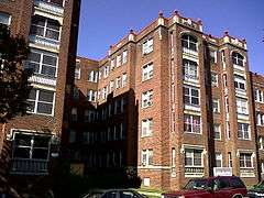
| 12 |
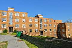
Dahlgreen Courts |
|
000000002010-11-10-0000November 10, 2010
(#10000901) |
2504-2520 10th St., NE
38°55′22″N 76°59′34″W / 38.922778°N 76.992778°W / 38.922778; -76.992778 (Dahlgreen Courts) |
Brookland |
Apartment Buildings in Washington, DC, MPS
|
| 13 |
East Capitol Street Carbarn |
|
000000001974-02-05-0000February 5, 1974
(#74002158) |
1400 E. Capitol St., NE.
38°53′23″N 76°59′06″W / 38.889722°N 76.985°W / 38.889722; -76.985 (East Capitol Street Carbarn) |
NE |
|
| 14 |
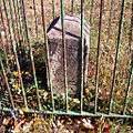
East Corner Boundary Marker of the Original District of Columbia |
|
000000001996-11-01-0000November 1, 1996
(#96001249) |
100 ft. E of jct. of Eastern and Southern Aves.
38°53′35″N 76°54′34″W / 38.893056°N 76.909444°W / 38.893056; -76.909444 (East Corner Boundary Marker of the Original District of Columbia) |
NE and SE |
See List of Boundary Markers of the Original District of Columbia
|
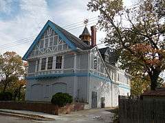
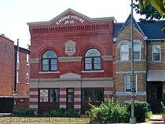
| 15 |
Engine Company 17 |
|
000000002007-06-06-0000June 6, 2007
(#07000538) |
1227 Monroe St. NE[4]
38°56′03″N 76°59′23″W / 38.934167°N 76.989722°W / 38.934167; -76.989722 (Engine Company 17) |
NE |
|
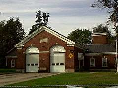
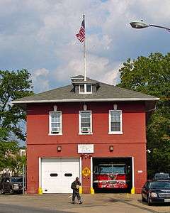
| 16 |
Engine Company 26 |
|
000000002011-05-18-0000May 18, 2011
(#11000283) |
1340 Rhode Island Ave., NE
38°55′29″N 76°59′12″W / 38.924722°N 76.986667°W / 38.924722; -76.986667 (Engine Company 26) |
Brookland |
Firehouses in Washington DC MPS
|
| 17 |
Engine Company 26, (Old) |
|
000000002007-08-08-0000August 8, 2007
(#07000536) |
2715 22nd St. NE
38°55′30″N 76°58′27″W / 38.925°N 76.974167°W / 38.925; -76.974167 (Engine Company 26, (Old)) |
NE |
|
| 18 |
Engine Company 27 |
|
000000002011-05-18-0000May 18, 2011
(#11000284) |
4201 Minnesota Ave., NE
38°54′04″N 76°56′36″W / 38.901111°N 76.943333°W / 38.901111; -76.943333 (Engine Company 27) |
NE |
Firehouses in Washington DC MPS
|
| 19 |
Engine House No. 10 |
|
000000002008-11-19-0000November 19, 2008
(#08001063) |
1341 Maryland Ave., NE
38°53′54″N 76°59′13″W / 38.898364°N 76.986866°W / 38.898364; -76.986866 (Engine House No. 10) |
NE |
|
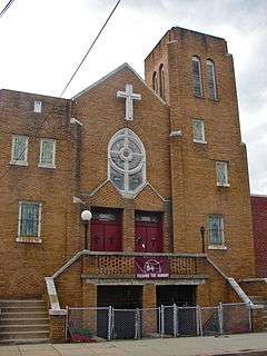
| 20 |
First Baptist Church of Deanwood |
|
000000002008-07-24-0000July 24, 2008
(#08000720) |
1008 45th St. NE
38°54′11″N 76°56′17″W / 38.903119°N 76.938°W / 38.903119; -76.938 (First Baptist Church of Deanwood) |
Deanwood |
|
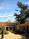
| 21 |
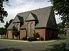
Franciscan Monastery and Memorial Church of the Holy Land |
|
000000001992-01-17-0000January 17, 1992
(#91001943) |
1400 Quincy St., NE.
38°56′13″N 76°59′00″W / 38.936944°N 76.983333°W / 38.936944; -76.983333 (Franciscan Monastery and Memorial Church of the Holy Land) |
Brookland |
|
| 22 |
Gallaudet College Historic District |
|
000000001966-10-15-0000October 15, 1966
(#66000856) |
Florida Ave. and 7th St., NE.
38°54′22″N 76°59′45″W / 38.906111°N 76.995833°W / 38.906111; -76.995833 (Gallaudet College Historic District) |
NE |
|
| 23 |
Glenwood Cemetery Mortuary Chapel |
|
000000001989-01-09-0000January 9, 1989
(#88003064) |
2219 Lincoln Rd., NE
38°55′19″N 77°00′22″W / 38.921944°N 77.006111°W / 38.921944; -77.006111 (Glenwood Cemetery Mortuary Chapel) |
NE |
|
| 24 |
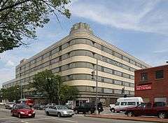
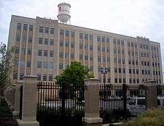
Hecht Company Warehouse |
|
000000001994-05-25-0000May 25, 1994
(#94000446) |
1401 New York Ave., NE.
38°54′52″N 76°59′06″W / 38.914444°N 76.985°W / 38.914444; -76.985 (Hecht Company Warehouse) |
NE |
|
| 25 |
Kenilworth Aquatic Gardens |
|
000000001978-08-25-0000August 25, 1978
(#78000258) |
Kenilworth Ave. and Douglas St. NE
38°54′46″N 76°56′37″W / 38.912778°N 76.943611°W / 38.912778; -76.943611 (Kenilworth Aquatic Gardens) |
NE |
|
| 26 |
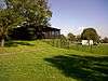
Langston Golf Course Historic District |
|
000000001991-10-15-0000October 15, 1991
(#91001525) |
Roughly, Anacostia Park N of Benning Rd. NE
38°54′08″N 76°57′54″W / 38.902222°N 76.965°W / 38.902222; -76.965 (Langston Golf Course Historic District) |
NE |
|
| 27 |
Langston Terrace Dwellings |
|
000000001987-11-12-0000November 12, 1987
(#87001851) |
N from Benning Rd. to H St., NE
38°53′58″N 76°58′26″W / 38.899444°N 76.973889°W / 38.899444; -76.973889 (Langston Terrace Dwellings) |
Kingman Park |
|
| 28 |
The Lexington |
|
000000002016-01-19-0000January 19, 2016
(#15000978) |
1114 F St., NE
38°53′51″N 76°59′28″W / 38.897570°N 76.991040°W / 38.897570; -76.991040 (The Lexington) |
Near Northeast |
|
| 29 |
Mayfair Mansions Apartments |
|
000000001989-11-01-0000November 1, 1989
(#89001735) |
3819 Jay St., NE
38°54′11″N 76°56′55″W / 38.903056°N 76.948611°W / 38.903056; -76.948611 (Mayfair Mansions Apartments) |
Mayfair |
|
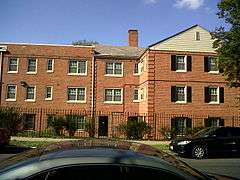
| 30 |
Metropolitan Apartments |
|
000000002014-05-12-0000May 12, 2014
(#14000199) |
200-210 Rhode Island Ave., NE.
38°55′09″N 77°00′12″W / 38.919253°N 77.003327°W / 38.919253; -77.003327 (Metropolitan Apartments) |
Edgewood |
|
| 31 |
Newton Theater |
|
000000002007-06-27-0000June 27, 2007
(#07000592) |
3601-3611 12th St. NE
38°56′08″N 76°59′27″W / 38.935556°N 76.990833°W / 38.935556; -76.990833 (Newton Theater) |
Brookland |
|
| 32 |
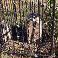
Northeast No. 3 Boundary Marker of the Original District of Columbia |
|
000000001996-11-01-0000November 1, 1996
(#96001256) |
144 ft. NW of jct. of Eastern Ave. and Chillum Rd.
38°57′17″N 76°59′17″W / 38.954722°N 76.988056°W / 38.954722; -76.988056 (Northeast No. 3 Boundary Marker of the Original District of Columbia) |
NE |
|
| 33 |
Northeast No. 4 Boundary Marker of the Original District of Columbia |
|
000000001996-11-01-0000November 1, 1996
(#96001255) |
5400 Sargent Rd.
38°57′17″N 76°59′17″W / 38.954722°N 76.988056°W / 38.954722; -76.988056 (Northeast No. 4 Boundary Marker of the Original District of Columbia) |
NE |
|
| 34 |
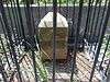
Northeast No. 5 Boundary Marker of the Original District of Columbia |
|
000000001996-11-01-0000November 1, 1996
(#96001254) |
4609 Eastern Ave.
38°56′39″N 76°58′28″W / 38.944167°N 76.974444°W / 38.944167; -76.974444 (Northeast No. 5 Boundary Marker of the Original District of Columbia) |
NE |
|
| 35 |
Northeast No. 6 Boundary Marker of the Original District of Columbia |
|
000000001996-11-01-0000November 1, 1996
(#96001253) |
3601 Eastern Ave.
38°56′01″N 76°57′41″W / 38.933611°N 76.961389°W / 38.933611; -76.961389 (Northeast No. 6 Boundary Marker of the Original District of Columbia) |
NE |
|
| 36 |
Northeast No. 7 Boundary Marker of the Original District of Columbia |
|
000000001996-11-01-0000November 1, 1996
(#96001252) |
Ft. Lincoln Cemetery
38°55′26″N 76°56′56″W / 38.923889°N 76.948889°W / 38.923889; -76.948889 (Northeast No. 7 Boundary Marker of the Original District of Columbia) |
NE |
|
| 37 |
Northeast No. 8 Boundary Marker of the Original District of Columbia |
|
000000001996-11-01-0000November 1, 1996
(#96001251) |
Kenilworth Aquatics Gardens, NW of jct. of Eastern and Kenilworth Aves.
38°54′50″N 76°56′10″W / 38.913889°N 76.936111°W / 38.913889; -76.936111 (Northeast No. 8 Boundary Marker of the Original District of Columbia) |
NE |
|
| 38 |
Northeast No. 9 Boundary Marker of the Original District of Columbia |
|
000000001996-11-01-0000November 1, 1996
(#96001250) |
919 Eastern Ave.
38°54′12″N 76°55′21″W / 38.903333°N 76.9225°W / 38.903333; -76.9225 (Northeast No. 9 Boundary Marker of the Original District of Columbia) |
NE |
|
| 39 |
Plymouth Theater |
|
000000002004-03-03-0000March 3, 2004
(#04000117) |
1365 H St., NE
38°54′07″N 76°59′11″W / 38.901944°N 76.986389°W / 38.901944; -76.986389 (Plymouth Theater) |
NE |
|
| 40 |
President's House, Gallaudet College |
|
000000001974-02-15-0000February 15, 1974
(#74002172) |
7th St. and Florida Ave., NE.
38°54′19″N 76°59′46″W / 38.905278°N 76.996111°W / 38.905278; -76.996111 (President's House, Gallaudet College) |
NE |
|
| 41 |
Roosevelt Apartment Building |
|
000000001994-09-07-0000September 7, 1994
(#94001045) |
1116-1118 F St., NE.
38°53′50″N 76°59′27″W / 38.897222°N 76.990833°W / 38.897222; -76.990833 (Roosevelt Apartment Building) |
Near Northeast |
|
| 42 |
Sewall-Belmont House National Historic Site |
|
000000001972-06-16-0000June 16, 1972
(#72001432) |
144 Constitution Ave., NE.
38°53′31″N 77°00′15″W / 38.891944°N 77.004167°W / 38.891944; -77.004167 (Sewall-Belmont House National Historic Site) |
NE |
|
| 43 |
Spingarn Senior High School |
|
000000002014-05-12-0000May 12, 2014
(#14000198) |
2500 Benning Rd., NE.
38°53′58″N 76°58′15″W / 38.899528°N 76.970917°W / 38.899528; -76.970917 (Spingarn Senior High School) |
Carver Langston |
|
| 44 |
Strand Theater |
|
000000002008-11-25-0000November 25, 2008
(#08001093) |
5129-5131 Nannie Helen Burroughs Ave., NE
38°53′54″N 76°55′34″W / 38.898331°N 76.926097°W / 38.898331; -76.926097 (Strand Theater) |
NE |
|
| 45 |
Trades Hall of National Training School for Women and Girls |
|
000000001991-07-17-0000July 17, 1991
(#91002049) |
601 50th St., NE.
38°53′46″N 76°55′48″W / 38.896111°N 76.93°W / 38.896111; -76.93 (Trades Hall of National Training School for Women and Girls) |
NE |
|
| 46 |
Truck House No. 13 |
|
000000002007-06-06-0000June 6, 2007
(#07000535) |
1342 Florida Ave. NE
38°54′05″N 76°59′13″W / 38.901389°N 76.986944°W / 38.901389; -76.986944 (Truck House No. 13) |
NE |
|
| 47 |
U.S. National Arboretum |
|
000000001973-04-11-0000April 11, 1973
(#73002122) |
24th and R Sts., NE.
38°54′42″N 76°57′58″W / 38.911667°N 76.966111°W / 38.911667; -76.966111 (U.S. National Arboretum) |
NE |
|
| 48 |
U.S. Post Office Department Mail Equipment Shops |
|
000000002016-07-11-0000July 11, 2016
(#16000435) |
2135 5th St., NE
38°55′09″N 76°59′58″W / 38.919030°N 76.999479°W / 38.919030; -76.999479 (U.S. Post Office Department Mail Equipment Shops) |
Eckington |
|
| 49 |
Uline Ice Company Plant and Arena Complex |
|
000000002007-05-17-0000May 17, 2007
(#07000448) |
1132, 1140, and 1146 3rd St. NE
38°54′18″N 77°00′11″W / 38.905°N 77.003056°W / 38.905; -77.003056 (Uline Ice Company Plant and Arena Complex) |
Near Northeast |
|
| 50 |
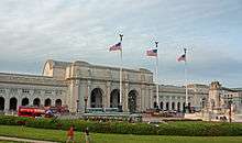
Union Station |
|
000000001969-03-24-0000March 24, 1969
(#69000302) |
Intersection of Massachusetts and Louisiana Aves. and 1st St., NE.
38°53′51″N 77°00′23″W / 38.8975°N 77.006389°W / 38.8975; -77.006389 (Union Station) |
NE |
|
| 51 |
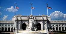
Union Station Plaza and Columbus Fountain |
|
000000001980-04-09-0000April 9, 1980
(#80004523) |
1st St., Massachusetts and Louisiana Aves., NE
38°53′47″N 77°00′23″W / 38.896389°N 77.006389°W / 38.896389; -77.006389 (Union Station Plaza and Columbus Fountain) |
NE |
|
| 52 |
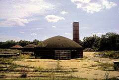
United Brick Corporation Brick Complex |
|
000000001978-10-03-0000October 3, 1978
(#78003061) |
2801 New York Ave., NE.
38°54′58″N 76°58′06″W / 38.916111°N 76.968333°W / 38.916111; -76.968333 (United Brick Corporation Brick Complex) |
NE |
|
| 53 |
Woodward & Lothrop Service Warehouse |
|
000000002005-02-15-0000February 15, 2005
(#05000046) |
131 M St. NE
38°54′25″N 77°00′17″W / 38.906944°N 77.004722°W / 38.906944; -77.004722 (Woodward & Lothrop Service Warehouse) |
Near Northeast |
|
| 54 |
Young, Browne, Phelps and Springarn Educational Campus Historic District |
|
000000002016-05-03-0000May 3, 2016
(#15000743) |
2500 Benning Rd., NE., 704, 820, & 850 26th St., NE
38°54′00″N 76°58′15″W / 38.900100°N 76.970798°W / 38.900100; -76.970798 (Young, Browne, Phelps and Springarn Educational Campus Historic District) |
NE |
|